Geographical information
Pyshma originates from Lake Klyuchi on the outskirts of Verkhnyaya Pyshma and flows into the Tura River 97 km from the mouth. The length of the river is 603 km. Basin - 19,700 km²
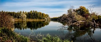
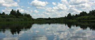
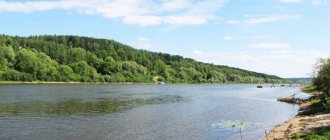
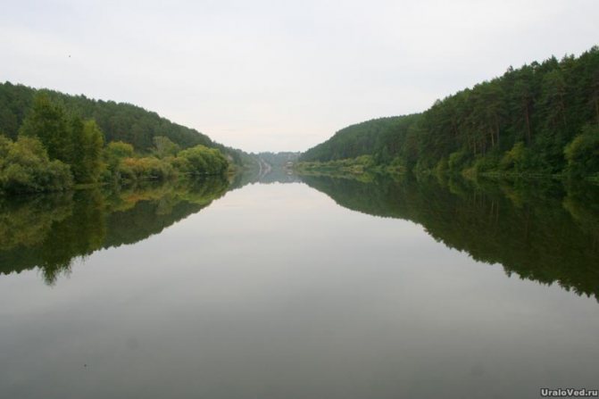
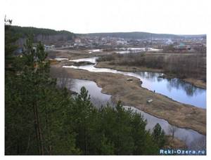
The fall of the river is 235 m, the average slope is 0.4‰. The upper part of the basin is located within the low spurs of the Ural Mountains and the hilly Trans-Ural Plateau. The river valley is narrow (0.2-0.5 km), shallow, with picturesque rocky cliffs and cliffs; covered with pine forest. The flat part of the basin is a pine-birch forest-steppe. The valley expands to 1-3 km, becomes trapezoidal with gentle terraced slopes. The forest-meadow floodplain, 0.8-2.5 km wide, is occupied by oxbow lakes, vegetable gardens and hayfields, and garden and dacha settlements. Flooded in high-water years.
The Pyshma is a flat river throughout its entire length. In the upper reaches, the width of the channel varies from 15 to 40 m. In the river bed there are many rocky rifts, rocky rifts and rapids with fast currents, alternating with calm reaches. In the riverbed and on the floodplain there are many dredge pits and excavations, flooded quarries and mines, and peat extraction ditches.
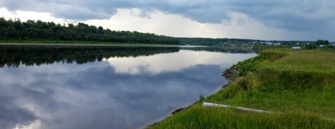
In the middle and lower reaches, the channel is meandering, 50-80 m wide. Depths on reaches are 2-3 m, and on rifts - 0.3-0.8 m. At concave banks of bends, depths can reach 7-8 m. The current is calm , speed 0.1-0.5 m/s; during high water it increases to 0.8 m/s.
The average long-term water flow is 34 m³/s (flow volume is 1.073 km³/year). Feeding is snow (60%) and rain. West Siberian type of water regime, with a relatively short (35-65 days) flood in April-May (in high-water years - until mid-June), with a smooth rise and fall of water levels. Maximum water flow is 1300 m³/s. In summer there are short rain floods.
The river bottom is flat, muddy-sandy on the reaches, sandy-pebble and rocky on the rifts. In summer, shallow waters are occupied by aquatic vegetation. River waters are polluted by industrial and domestic wastewater.
Main tributaries: Belyakovka (right); Reft, Yurmych (left).
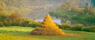
The Pyshma Valley has long been developed and densely populated; On the banks of the river there are industrial cities and towns: Verkhnyaya Pyshma, Sukhoi Log, Kamyshlov, Talitsa, Zarechny, Berezovsky, Beloyarsky, as well as numerous villages and hamlets.
Features of the Pyshma River
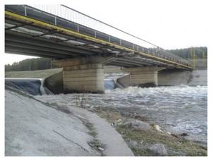
The Beloyarsk reservoir was created on the river, intended for the needs of the Beloyarsk NPP. In the first years of operation, radioactive waste entered the Pyshma River basin. However, this had almost no effect on the Beloyarsk Reservoir, in particular, the fish there are completely normal and do not have an elevated background. There are also several small ponds.
The largest settlements on the banks of the Pyshma River: Verkhnyaya Pyshma, Berezovsky, Staropyshminsk, Zarechny, Beloyarsky, Sukhoi Log, Kamyshlov, Pyshma, Talitsa. Due to enterprises and other human activities, the river is heavily polluted.
In 1745, in the upper reaches of the Pyshma, peasant Erofey Markov from the village of Shartash discovered what is believed to be the first gold in Russia (although not so long ago local historians established that the first gold was discovered on the Iset River - at the Shilovo-Isetsky mine).
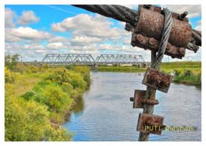
On the Pyshma River near the village of Stanovaya, a dredge still operates today to extract gold. According to local historian Boris Maidanik, this dredge was manufactured in the city of Votkinsk; it has been operating on the Pyshma River since 1934. Over time, having completely worked out the upper reaches of the river, the dredge reached the railway bridge near the Berezit station. The three-story dredge, naturally, could not pass under it. To allow it to pass, they decided to temporarily raise the bridge. For this purpose, four vertical trusses with lifting winches were built nearby. A dam was built below the bridge, causing the river to overflow and form a pond. And so, on July 9, 1962, the bridge was raised and the dredge passed downstream. The whole operation took 2 hours 20 minutes. This was the first time this had been done in the USSR.
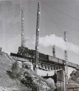
Preparation for raising the railway bridge across Pyshma for the passage of the dredge.
In the past, Old Believers hid in some places on the Pyshma River. According to researcher S.A. Beloborodov, after the authorities destroyed the Kazan monastery on Shartash, 15 versts from the village of Beloyarsky, Yekaterinburg district, Mother Faina settled on the left bank of the Pyshma (in the world - Marfa Grigorievna Chuvakova). It was possible to get to the settlement only through a single bridge, which was dismantled in case of danger. Bishop Gennady of Perm, one of the most significant figures among the Old Believers of the Belokrinitsky Consent (the so-called “Austrians”), often stayed with Mother Faina. The name of Gennady (Grigory Vasilyevich Belyaev) is associated with a significant increase in the activities of representatives of the Belokrinitsky Church in the Urals and Siberia. He held the rank of Bishop of Perm from 1857 to 1862. Gennady was arrested several times, he was in prisons and prison companies, but he did not renounce his faith.
In the spring, tourist rafting takes place along the Pyshma River. Although there are few tourists here. Rafting can start in Beloyarskoye or from Belokamenny, and end in Sukhoi Log or Kuryakh. These places are also interesting for hiking.
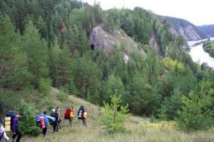
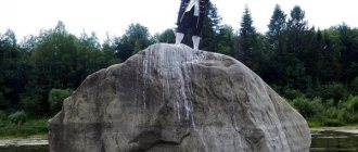
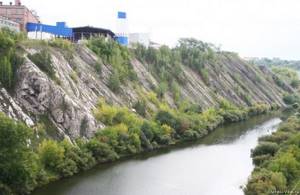
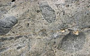
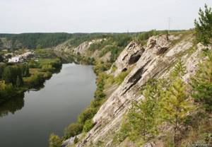
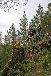
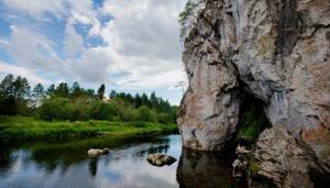
The main highlight of the river is the coastal rocks. Fossils are found on them in places.
The first rocks downstream are found in the village of Staropyshminsk. For the rare plants growing on them, they received the status of a natural monument of the Sverdlovsk region.
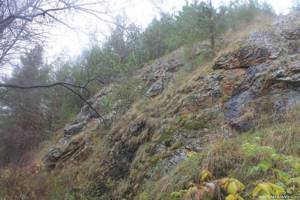
Some rocks have their own names: the Diviy (or Divya Gora) stones, Kovrizhka, Bryukhanov, Devil's Chair, Three Sisters. Others are nameless.
The Divy Stone is located on the left bank of the river near the village of Znamenskoye. These are the remains of an ancient volcano. At the base of the rock you can see tuffs and jaspers of purple and red color. At the end of July - beginning of August, the student song festival “Znamenka” is held here.
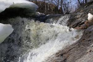
And in front of Sukhoi Log, a small river Shata flows into the right. The Shata (or Shatsky) waterfall of the same name was formed on it. You need to see it in the spring, because in summer it is only a small trickle of water.
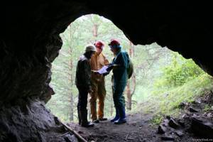
The most picturesque rocks are within the city of Sukhoi Log. They have many caves.
The most famous of these caves is named after the mining engineer F.Yu. Gebauer, who studied it in the 1870s. In the cave he discovered traces of an ancient man.
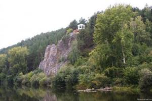
Downstream there are also a number of rocks. And in front of the village of Kurya, hidden behind the forest, is the Devil’s Chair rock, named for its characteristic shape. Finding the rock is not easy, since in recent years it has been heavily overgrown with forest.
There is a stone rotunda on the Three Sisters rock. According to legend, three sisters, having fallen in love with one young man, threw themselves off a cliff into the river so as not to build their happiness on the misfortune of their sisters. On the mountain there is the resort-sanatorium “Kuryi”, which has long been famous for its mineral waters.
V.A. Vesnovsky wrote about these places in his “Guide to the Resorts of the Urals” in 1902:
“Here the Pyshma River has cut through a mountain ridge, spurs of the Ural ridge, and emerges into the open space from rocky, rocky shores. Higher up from the sources, the banks of Pyshma amaze with their bizarre outlines and stretch like a continuous rocky ridge. Some rocks rise up several tens of fathoms. In some places, such a steep barrier stretches along the shore for several fathoms, presenting an original spectacle... The area occupied by the resort is one of the most beautiful places in the vicinity of the Urals. Nature has given everything here to live calmly and happily in its bosom for several summer weeks, taking a break from the usual squabbles and city prose, and breathing in the clean, healthy mountain air, full of ozone. The main beauty of the resort is the rocks. They are sometimes brown, sometimes brown, but majestically proud, rising now on the right and now on the left bank of the river. Pyshma. At their foot the river spreads like a snake, silvering with its smooth mirror surface. Masses of brown stone protrude like humps above the water, piled on top of each other, forming figures of bizarre shape. Where possible, pine trees have strengthened along their ridges and slopes and stand proudly in their evergreen attire. Right there, like an orphan, the birch tree got lost, lowering its curly branches to the ground. All these rocks are masses of limestone of a brownish-dirty color, speckled with rusty spots and covered with moss.”
Pyshma - a river near Tyumen
Published by: zampolit, 12/18/2014, 06:18, Travel routes, 7 876, 0
Pyshma
flows from Lake Klyuchi in the vicinity of the city of Verkhnyaya Pyshma (Sverdlovsk region) and flows into the Tura about 4 kilometers below the village of Sozonova.
The length of Pyshma is 614 kilometers, including 150 kilometers within the Tyumen region. Unlike Tura, Pyshma is very winding, replete with riffles and whirlpools. Its width is from 30 to 100 meters, depth from 0.7 to 8 meters. In the channel there are individual islands and entire groups of them. The Pyshma catchment area reaches 19,700 sq. km. Three reservoirs were built on Pyshma within the Sverdlovsk region: near the village of Beloyarsky, the city of Sukhoi Log, and 8 km below the city of Kamyshlov. Near Tyumen, tributaries flow into Pyshma from the left - Karmak, Ushakovka, Duvan, from the right - Chaplyk, Balda, Bardyanka, Chernaya Rechka , Scurvy, Hag, Boganda, Black. They are longer and richer than the tributaries of the Tura. Pyshma
usually disappears around mid-April, on average April 13th. The earliest date for the start of ice drift is March 30, 195, the latest is April 30, 1914. On the winding and narrow Pyshma, the ice often melts without moving. The highest level of rise in Pyshma occurs at the end of April - beginning of May. During the day, the water rises by 10-50 centimeters, gradually reaching a maximum level that lasts 1-5 days, after which the flood begins to decline.
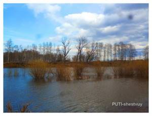
During a flood, water quickly enters the river valley and floods the floodplain.
Through streams, ditches, and oxbow lakes, water first penetrates into the lowest places, then floods the middle part of it, and lastly, the so-called riverbed shaft, the highest place of the floodplain. However, the release of water onto the floodplain does not happen every year, but only during a major flood. The floodplain is under water for 20-30 days, the water depth on the floodplain reaches 2-4
meters.
In spring, Pyshma usually floods its entire valley - 1.5-2
km (in the lower reaches). At this time, the tributaries flow backwards - from the bottom up, the water fills all the floodplain lakes, penetrates through the swampy lowlands far into the depths of the Pripyshma forests. After the flood, the water gradually subsides, and in late July-early August the summer-autumn low water level sets in. This is the name given to the lowest level in the river. However, summer rain floods are often observed at this time, although they are usually much smaller than spring ones.
In autumn the rivers begin to freeze.
Small rivers and streams freeze from their banks, where banks form and increase every day. Sections of rivers with a quiet flow - reaches - are the first to freeze. On Pyshma, small pieces of ice, the so-called “fat”, first form. When there is a lot of it, “shuga” flows down the river - autumn ice drift. It doesn’t happen to Pyshma every year. Gradually the slush freezes and freezes up. On Pyshma near Bogandinsky, freeze-up occurs on average on November 9, the earliest date is October 20, and the latest is November 30. The river is under ice for an average of 165 days. By the end of March and beginning of April, the ice reaches its greatest thickness - 50-70
cm, but it depends on the snow content, severity and duration of winter and therefore varies in different years.
The shallow tributaries of the Pyshma often freeze to the bottom. In severe frosts, the ice cracks, water comes up and freezes, forming ice dams. Here the ice thickness reaches 1.5-2
meters. In winter, rivers switch to groundwater feeding, so their level decreases, reaching a minimum in December-January (winter low water). The ice turns out to be torn away from the water and collapses and settles under its own weight. So, in the fall of 1984, the Pyshma floodplain before the freeze-up was flooded with water from the autumn flood. When ice about 20 cm thick formed, the water left. The ice settled, and vast areas of the floodplain were covered with a thick ice shell, which collapsed in the river bed to a height of 1.5-2 meters. A similar phenomenon was observed in the winter of 1986/87. Pyshma within the Tyumen region is intensively used as a source of drinking water. A lot of it goes to technical and agricultural needs. Many agricultural joint-stock companies in the region have irrigated plots where vegetables and fodder crops are grown.
Even during the war years, Pyshma was used in the spring to float local timber to the timber exchange and sleeper cutting plant in Vinzily, but during the 80-90s of the 20th century it became fairly shallow.
In pre-revolutionary times, there were several water mills on Pyshma, which were destroyed when steam and electric mills appeared. One place near Vinzili reminds of them; it is still called the Mill. There are remains of a dam there. 20 kilometers from Tyumen the Chervishevsky tract crosses the Pyshma River. Here it flows in a wide – up to 4 km – valley, but the river itself is narrow: at low water it is no wider than 30-40
meters.
The average depth is about 2
meters. Pyshma flows slowly and fully justifies its name, derived from the Tatar word “poshmas” - unhurried, slow, calm. It often changes its channel, washing a new one in the sandy soil at the bends. For this reason, there are many oxbow lakes of different sizes and ages in the floodplain. The most ancient ones have long been turned into swamps, the banks are densely overgrown with willows and grass. This created good conditions for numerous waterfowl to live in the Pyshma floodplain. Along the river from the village of Onokhino to the border with the Sverdlovsk region there were the Chervishevsky and Uspensky complex reserves. Since 1995, the Chervishevsky reserve has been closed. On the left bank of the Pyshma near the bridge there was a pioneer camp “Chaika”. Here, in 1914, a training and experimental site was organized at the Chervishevsky rural 2-grade school. Working on the site, students received basic knowledge of agriculture, and also carried out demonstration experiments in the cultivation of agricultural services. The site occupied an area of 13 acres. In 1922, the provincial land authorities created a state farm-agricultural center here for experimental and demonstrative purposes, where new agricultural machines and methods of cultivating crops on the sandy and peat soils that were on the site were demonstrated to the peasants of the surrounding villages. To the right of the road there is the “Setka” gardening and dacha partnership and the “Pyshma” fish farm, which breeds fish in ponds with mineral water of the same composition as at the Taraskul well. It was built in 1975. A system of fish ponds has been created on the banks of the Pyshma, two wells supply warm underground water. It was once the country's first geothermal fish farm. From here, fry of carp and other fish are transported to the lakes of our and neighboring regions. The first bridge across Pyshma in this place was built in 1912. Before this, we crossed on a ferry that could accommodate 4 carts, or took a detour to the Onokhinsky bridge. In 1971, when the highway was reconstructed, a reliable reinforced concrete bridge was built on Pyshma. In July 1918, there were fierce battles along Pyshma: detachments of Red Guards defended Tyumen from the White Czechs and White Guards advancing from Kurgan. The fighting went on for almost two weeks. Only under the pressure of superior enemy forces on July 19 did the red detachments leave for the Urals.
- 80
Serga River
The Serga is not a very large, but clean river, its length is 113 km, and the basin covers an area of 2170 square kilometers. It flows through the territory of the Sverdlovsk region through two reservoirs: Verkhneserginskoye and Nizhneserginskoye and flows into Ufa. It is rich in colorful caves and grottoes, as well as archaeological sites. In the upper reaches of the river it is sparsely populated, and in the lower reaches, Serga is one of the main components of the Olenyi Ruchi natural park.
Fishing and rafting on the Serga River
The river is one of the most visited for rafting; tourists love it very much. The rocks on the banks are full of various caves, which can only be accessed from the water. For many millions of years, the waters of the Sergi washed away various underground labyrinths, resulting in the formation of a colorful valley. If you go rafting in the spring, you need to be very careful, the current is too fast at this time of year, it can push you against the rocks. The route starts from the city of Nizhnie Sergi and ends in Mikhailovsk. In summer, the river becomes very shallow and the time it takes to pass through the same sections as in spring can greatly increase.
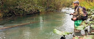
You can catch fish on Serga both in winter and in summer; there is a lot of it here. The most common: roach, chebak, bream, chub, pike, grayling. The latter can only be caught in the upper reaches of the river.
Tavda River
The Tavda is a very long river, its length is 719 km, and its basin is 88.1 thousand km². The source of the river originates on the slope of the Ural Mountains, and, at the end of the path, flows into the Tobol River. In the 70s of the last century, there was a hydropathic clinic famous throughout the Union with mineral water containing a large amount of iodine.
The river is very picturesque and navigable; in the past it was used for rafting timber, but a large amount of driftwood greatly spoils the appearance. It has different banks, one high and rocky, and the second flat with large thickets. The average depth of the Tavda River is 3-8 meters. It has no lakes or reservoirs.
Rafting and fishing on the Tavda River
The river is one of the best for fishing and is very rich in the number of fish species. Industrial fishing is highly developed on it. For amateurs, in summer you can catch good catches of ide and perch, and autumn is an excellent time for pike fishing. In winter, pike and perch are excellently caught. The best bite is on the Tavda tributary - Vagil and Vagilsky Tuman, but getting there is very difficult, you need a helicopter or motor boat. It is prohibited to fish in the place where the Tavdinsky fish factory catches fish.
The river is suitable for rafting, during which you can enjoy the beauty of the coastline. A good route: start the rafting from the village of Pelym and end it in the city of Tavda.
Tributaries
(km from the mouth)
|
|
|
Pyshma
Pyshma is a river in the Asian part of Russia, in the Middle Urals and Western Siberia, in the Sverdlovsk and Tyumen regions; tributary of the river Tours (Obi swimming pool).
The name of the river comes from Mansi - “quiet” or Tatar “poshmas” - “calm”, “slow”.
Pyshma originates from Lake Klyuchi on the outskirts of the city of Verkhnyaya Pyshma and flows into the river. Turu is 97 km from the mouth. The length of the river is 614 km; The basin area is 19.7 thousand km2 - the 2nd largest tributary of the Tura [*] in terms of basin area (after Nitsa) and the 1st in length. Main tributaries: Belyakovka (right); Reft, Yurmych (left).
The climate of the basin is continental, with cold winters and warm summers. The annual precipitation is 450 mm (most of it falls in summer). The thickness of the snow cover is 45–60 cm. The magnitude of the river fall is 235 m, the average slope is 0.4‰. The upper part of the basin is located within the low spurs of the Ural Mountains and the hilly Trans-Ural Plateau. The river valley is narrow (0.2–0.5 km), shallow, with picturesque rocky cliffs and cliffs; covered with pine forest. The flat part of the basin is pine-birch forest-steppe. The valley expands to 1–3 km and becomes trapezoidal with gentle terraced slopes. The forest-meadow floodplain, 0.8–2.5 km wide, is occupied by oxbow lakes, vegetable gardens and hayfields, and garden and dacha settlements. Flooded in high-water years.
Pyshma is a flat river along its entire length. In the upper reaches, the width of the channel varies from 15 to 40 m. In the river bed there are many rocky rifts, rocky rifts and rapids with fast currents, alternating with calm reaches. In the riverbed and on the floodplain there are many dredge pits and excavations, flooded quarries and mines, and peat extraction ditches. In the middle and lower reaches the channel is meandering, 50–80 m wide. Depths on reaches are 2–3 m, and on rifts 0.3–0.8 m. At concave banks of bends, depths can reach 7–8 m. The current is calm, the speed 0.1–0.5 m/s; during high water it increases to 0.8 m/s. Bed deposits in the upper and middle reaches of the river are pebbles, sand, in the lower reaches - sand and silt. In summer, shallow waters are occupied by aquatic vegetation.
The average long-term water flow is 34 m3/s (flow volume is 1.073 km3/year). Feeding is snow (60%) and rain. West Siberian type of water regime, with a relatively short (35–65 days) flood in April–May (in high-water years - until mid-June), with a smooth rise and fall of water levels. In April–May, 62% of the annual water flow occurs. Maximum water flow 1300 m3/s. In summer there are short rain floods. Minimum levels are typical for winter low water. Minimum water flow is about 2 m3/s. In the upper reaches, the river flow is regulated by three reservoirs (Beloyarsk provides water supply to the Beloyarsk NPP) and numerous low-pressure dams of factory ponds. The range of seasonal changes in water level is 3–3.5 m; in the lower reaches of the river and in high-water years - up to 6–7 m. The river freezes in late October - early November. The ice thickness does not exceed 70–90 cm. In cold winters, ice forms in the river valley. The river becomes ice-free at the beginning of April (it is ice-free for 170–200 days).
The turbidity of the river during flood is 170–300 g/m3, the flow rate of suspended sediment is up to 60 kg/s. Up to 80% of the suspended sediment runoff occurs during the flood period. The water's chemical composition belongs to the hydrocarbonate class and the calcium group (in the upper reaches it belongs to the sulfate class). Water mineralization 200–600 mg/l. River waters are polluted by industrial and domestic wastewater.
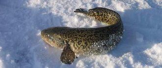
Gold, copper ores, asbestos, and peat are mined in the basin and valley. Pyshma is a popular tourist destination; There are many beautiful places, historical and archaeological monuments along the banks of the river. Recreation areas have been created at the Beloyarsk Reservoir; in the city of Sukhoi Log there is the largest climatic and balneological resort “Kurya” in the Urals and Western Siberia. On the right bank (middle course of the river) there is the Pripyshminskie Bory national park. The river is home to pike, perch, bream, tench, carp, dace, burbot, ide, grass carp, and pike perch.
The Pyshma Valley has long been developed and densely populated; On the banks of the river there are industrial cities and towns: Verkhnyaya Pyshma, Sukhoi Log, Kamyshlov, Talitsa, Zarechny, Berezovsky, Beloyarsky, as well as numerous villages and hamlets.
V.V. Surkov, R.S. Chalov