Name of the river Ugra
There is some debate regarding the etymology of the river's name. Some believe that this name is not of Slavic, but of Finno-Ugric origin. In this language, the root "uga" ("yuga") means "river". Others believe that the word "Ugra" goes back to the Old Russian Qgr', which means "worm". It is from this lexeme that the modern word “eel” originates. If we take this hypothesis into account, we can assume that in ancient times people nicknamed the river “twisting, winding” for the fickle nature of its flow, abruptly changing its direction.
The origin of the Ugra River, some associate its name with the Magyar settlement that stood on its bank in ancient times. The tribal name of the Magyars was the word "Ugrians".
Fishing and hunting on the Ugra River
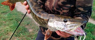
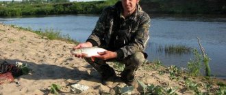
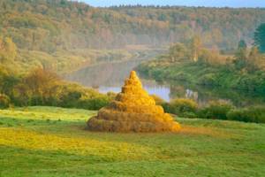
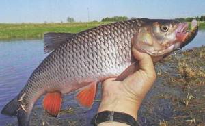
And the Ugra River can satisfy fishing rod lovers. They associate fishing with many representatives of the aquatic ichthyofauna - pike, perch, ruffe, crucian carp, pike perch, silver bream, bream, carp, topwater, ide and even catfish. Do you like spending time at fishing bases? And on this basis the Ugra River is suitable for you. Fishing will take place quietly on the embankments of several recreation centers. And also where there are few people. After all, 85% of its route is dense, deserted forest areas. As a result, the Ugra River is famous for its very good, memorable bite. Fishing, they say, brings good luck in places where there is depth, solid reeds and snags. They are loved by pike, catfish and carp. People who know praise the village of Belyaevo, the village of Dvortsy, the outskirts of Tuchnevo, Znamenka.
When talking about what the Ugra River is, the natives do not put fishing in the first place. Know that there is also hunting on the edge of the floodplain. True, mainly for swamp and meadow game. The fact is that in the 67th region they still cannot restore the standard population sizes of various animals. For hundreds of years, the region was the site of noble amusements of the nobility of several states, and also the site of hundreds of military skirmishes, which led (along with fires) to the almost complete extermination of game animals.
Hydrological description
The length of the river is 399 kilometers. The basin area is approximately 15,700 km2. The source of the Ugra is located in the southeastern part of the Smolensk region.
The Ugra is a river that is fed in several ways: 60% of the annual flow comes from melt water, 30% is groundwater, and only 5% of the flow comes with precipitation. The river level regime is characterized by high, clearly defined floods, fairly low low water in the summer-autumn period, sometimes interrupted by floods due to heavy rains, and consistently low low water in winter. At the end of March, the ice on the river melts, and the spring flood begins, which ends in early May. During this period, the water level rises by 10-11 meters compared to winter low water. The average water flow in the river per year is 90 m3 per second.
The Ugra is covered with ice from late November to January. The river never freezes on the rifts; due to the strong current, the thickness of the ice on the Ugra varies.
The river valley is characterized by a large number of floodplains, the width of which reaches 1-2 kilometers, and in the lower reaches - 3.5 kilometers. The width of the Ugra channel is 70-80 meters in the lower reaches. The average speed of the river flow is 0.4-0.6 m/s.
Ugra
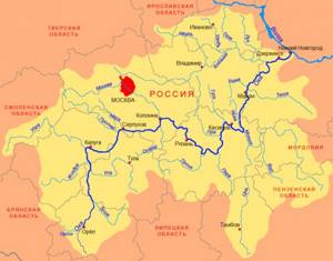
Ugra is a river in the European part of Russia, in the Smolensk and Kaluga regions; left tributary of the Oka (Volga basin).
It became famous in history in connection with the confrontation between the troops of the Khan of the Great Horde Akhmat and the Grand Duke Ivan III in the fall of 1480 (“Standing on the Ugra”). During the War of 1812, Denis Davydov’s partisans and Yukhnovsky militias operated in the river basin, preventing the French from occupying this territory. During the Great Patriotic War of 1941–1945. Ugra became one of Moscow’s natural defense lines.
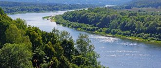
The river originates on the Smolensk-Moscow Upland; flows into the Oka 12 km above Kaluga. The length of the river is 399 km, the basin area is 15.7 thousand km2 - the 4th tributary of the Oka River in terms of basin area and length[*]. The largest tributaries: Resa (right); Vorya, Shanya, Sukhodrev (left). There are 213 lakes and reservoirs in the Ugra basin with a total area of 4.76 km2.
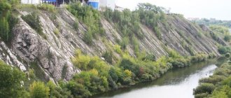
The upper part of the basin (heights up to 250–300 m) has a dense network of ravines and gullies. In its lower reaches, the Ugra flows through a slightly and moderately hilly plain composed of loams and sandy loams. The climate of the basin is moderate continental. The average annual air temperature is +4.0°С…+4.5°С. The average temperature in January is -10°C, in July – +17°C. On average, 600–650 mm of precipitation falls annually (most of it in the form of summer rains). The river basin is located in the mixed forest zone. Forests occupy about 63% of the basin's area.
In the upper reaches, the slopes of the valley are moderately steep, 4–15 m high; in the lower reaches, the steepness of the slopes increases, and the depth of the valley incision reaches 30–40 m. Gully erosion is developed on the slopes of the valley. The width of the valley in the lower reaches of the river is 3.5 km. The width of the floodplain varies from 1–2 to 3.5 km. In the lower reaches, the width of the channel is 70–80 m. The banks are steep, steep, 3–5 m high, composed of sand and sandy loam, and are easily eroded. The riverbed of the Ugra is moderately winding and unbranched. The depth of the channel during low-water periods is 0.4–0.6 m on the rifts, 4 m on the reaches. The current speed is 0.4–0.6 m/s. Bed sediments: sand, gravel.
The average long-term water flow in the lower reaches of the river is 89.0 m3/s (flow volume is 2.809 km3/year). The river is fed predominantly by snow. Eastern European type of water regime. The spring flood begins at the end of March and ends in the first ten days of May. Maximum water flow 3460 m3/s. The river is characterized by relatively stable summer-autumn low water. The minimum water flow during the open channel period is 13.8 m3/s. In winter it decreases to 10.3 m3/s. The river freezes in November - early January. The ice cover is destroyed in late March - early April.
Water mineralization in summer low water is 260–360 mg/l, in winter it increases to 400–500 mg/l. The water's chemical composition belongs to the hydrocarbonate class and the calcium group, and its quality corresponds to conditionally pure water.
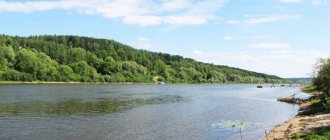
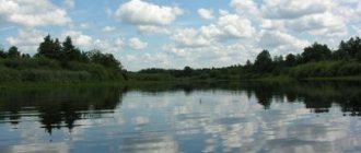
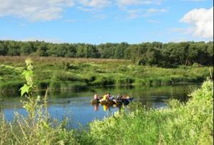
Ugra is an attractive destination for water tourists. Since 1997, the Ugra National Park has been operating in the river basin. This river remains one of the cleanest and richest in fish rivers in the distant Moscow region. It is home to pike, perch, roach, bream, asp, burbot, podust, chub, pike perch, catfish, sterlet, etc. On the bank of the river is the city of Yukhnov, many villages.
N.I. Alekseevsky, K.F. Retheum
Source of the river
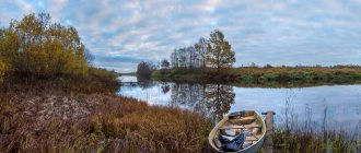
The Ugra is a river originating in the Smolensk region, Elninsky district, 25 kilometers from the city of Elnya, 2 km from the village of Vysokoye. This place has been declared a natural monument of local importance. The natural boundaries of this protected area are the territory of the lowland in which it is located. The source of the river is a small swamp, which is fed by surface water flow. The Ugra Valley in this place is almost not expressed; it is almost completely overgrown with small forests and small bushes. Birch predominates among the trees here, aspen is less common. The age of green spaces reaches 35-40 years. Only near the village of Vysokoe the river takes on its usual appearance with a well-defined channel and normal flow.
Tributaries of the river
In the Kaluga region, the river extends its bed for 160 kilometers. Many streams and rivers flow into the Ugra. Its main tributaries are: Zhizhala, Izver, Shanya, Techa, Ressa, Vorya, Rosvyanka, Veprika, Verezhka, Sokhna, Kunova, Remezh, Uzhaika, Debrya, Dymenka, Gordota, Oskovka, Makovka, Baskakovka, Sobzha, Tureya, Voronovka, Sigosa , Volosta, Leonidovka and many others. In total, the Kaluga River Ugra has 44 tributaries. Its bed consists of pebbles and fine sand. The Ugra flows into the Oka at a distance of ten kilometers upstream from the city of Kaluga.
Tributaries
(distance from mouth)
- 2 km: Rosvyanka river (pr)
- 13 km: Veprika river (lv)
- 36 km: Shanya River (lv)
- 47 km: Izver River (Izverya) (lv)
- 75 km: Techa River (pr)
- 99 km: Verezhka river (lv)
- 112 km: Sokhna river (lv)
- 115 km: Kunova River (pr)
- 120 km: Remezh River (pr)
- 121 km: Ressa River (pr)
- 123 km: Uzhaika River[3] (pr)
- 149 km: Sobzha River (pr)
- 154 km: Vorya river (lv)
- 159 km: Uika River (lv)
- 185 km: Tureya River (lv)
- 204 km: Zhizhala River (lv)
- 205 km: Voronovka river (lv)
- 232 km: Sigosa River (pr)
- 236 km: Volosta River (lv)
- 243 km: Leonidovka River (pr)
- 248 km: Elenka River (lv)
- 255 km: Bolshaya Slocha River (pr)
- 265 km: Debrya River (lv)
- 274 km: Dymenka River (lv)
- 279 km: Gordota River (lv)
- 280 km: Oskovka River (pr)
- 286 km: Makovka River[4] (pr)
- 288 km: Baskakovka River (pr)
- 289 km: Vorona River[5] (pr)
- 302.3 km: Yasenka River (lv)
- 303 km: Nezhichka River (lv)
- 322 km: Polyanovka river (lv)
- 328.8 km: Guda River (pr)
- 326.8 km: Uzhrept river (pr)
- 327.3 km: Nevestinka River (lv)
- 339 km: Zhostovnya river (pr)
- 347 km: Chernavka river (lv)
- 360 km: Leshchenka river (lv)
- 363 km: Usia River (lv)
- 366 km: Teremshenya river (Teremshon, Teremsha) (lv)
- 372 km: Demina River (pr)
- 374 km: Klyuchevka River (Klyuevka) (lv)
- 380 km: Dobrichka river (lv)
- 388 km: Ugrichka River (pr)
Historical facts
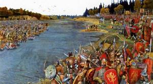
The Ugra is a river that often served as a natural border between different political and ethno-tribal entities. Beginning in 1147, chronicles contain references to political clashes on it. The so-called “standing on the Ugra River” became widely known. This is how Russian chronicles refer to the confrontation that took place between the Grand Duke of Moscow Ivan the Third and the Khan of the Great Horde Akhmat in 1480. This moment in the history of Rus' is considered the end of the Tatar-Mongol yoke. The defensive significance of the Ugra is emphasized by the nickname that the people awarded it - “The Belt of the Virgin”.
On the banks of the Ugra River, many Russians distinguished themselves with glorious military exploits. Here in 1812 the famous Denis Davydov held the defense. During the Second World War, during the attack of Hitler's troops on Moscow, the Ugra became a natural barrier between the defenders of the Motherland and the invaders. A.G. accomplished a feat on the river. Rogov, squadron commander. He sent his burning plane to the fascist crossing across the Ugra and destroyed it.
webmandry.com
The Ugra River is located on the territory of the Smolensk and Kaluga regions of Russia. The Ugra belongs to the Volga basin and flows into the Oka, being its left tributary. Ugra is known primarily due to the historical event of 1480 called: “Standing on the Ugra River.” This “stand” put an end to the Mongol-Tatar yoke and made the Moscow state completely independent.
River length: 399 kilometers.
Drainage basin area: 15,700 km. sq.
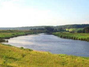
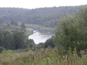
Where it flows: The source of the river is in the southeastern part of the Smolensk region on the Smolensk Upland. Almost along its entire course, the Ugra is surrounded by high banks covered with forest. In some places there are still treeless areas. In the lower reaches, sandy beaches are quite common. The Ugra, as already mentioned, flows into the Oka, 15 km above Kaluga.
Map:
Inhabitants, fishing on the Ugra: the fish in the river are basically the same as in the Oka. These are the commercial species: burbot, bream, pike, podust, roach, chub. In the lower reaches you can find pike perch, sterlet, and catfish.
Video: “Cool place. Ugra River fishing.
https://www.youtube.com/watch?v=ANbOvKVU91c
To protect the environment, the Ugra National Park was created in 1977. The river also has its own website called “IN THE MIDDLE STREAM OF THE UGRA RIVER“
Feeding: the river has a mixed type of feeding. Melt water accounts for 60% of its nutrition, the river receives 30% of its nutrition from groundwater, and approximately 5% from rainwater. Due to the feeding characteristics, with a predominance of melt water, the river regime is characterized by high spring floods. Summer low water may be interrupted by rain floods. Winter low water is more stable and low.
The width of the river bed is 70-80 m. The depth at low water on the rifts is 0.4-0.6 and on the reaches up to 4 meters.
Now briefly about the so-called “standing on the Ugra River” . This event occurred in 1480, as a result of the war between the Moscow prince Ivan III and the khan of the Great Horde Akhmat. Ivan III refused to pay tribute to the Horde in 1476 and was forced to accept battle.
Akhmat's attempts to cross the Oka were unsuccessful. Therefore, he made an attempt to enter from the flank. To do this, enlisting the support of the Polish-Lithuanian king Casimir IV. Casimir himself was unable to provide military assistance, as he was distracted by Moscow's ally, the Crimean Tatars. In addition, Ivan III, taking advantage of the fact that Akhmat had gathered all his forces on the Ugra, sent a sabotage group into the Khan’s possessions with the goal of carrying out a devastating raid and possibly capturing and plundering the capital of the Horde, Sarai.
Both troops stood on the river for almost a month without engaging in a decisive battle. In the end, on October 28, 1480, Ivan III began to withdraw his troops to Kremenets and then concentrated at Borovsk, so that here in a favorable environment they would meet the Tatars if they decided to cross the river, but Akhmat did not dare and on November 11 began returning to the Horde. After these events, the Ugra River received the name “Belt of the Virgin”.
If you like historical reconstructions, you can visit the festival of historical reconstruction and fencing: “Standing on the Ugra River.”
Here is a video from the festival:
Fishing on the river
In Ugra you can catch a wide variety of fish: pike, burbot, roach, bream, silver bream, sterlet, catfish or pike perch. On the stern stretch, which is located below the riffle, pike are caught well with live bait or spinners. Other representatives of the river's fish fauna prefer the worm. In spring, it is better to catch asps using the May beetle. At the end of summer, the chub bites well on the grasshopper. Experienced fishermen keep their catch on a kukan and in a cage, since a muskrat or otter can sneak up unnoticed and take the precious catch for themselves.
National Park
The Ugra River is considered one of the cleanest in the central region of Russia. The Kaluga region is famous for its magnificent nature. In 1997, the Ugra National Park appeared in this area, which is a specially protected natural area. A number of vascular plants (1026 species) grow here, some of which are imported from North America, others represent the local flora. In the national park there are 140 rarest species for the Kaluga region: Lady's slipper, Baltic palmate, feather grass, Neottiantha capulata, Pollencap longifolia and others. Many of these plants are in the Red Book of the Russian Federation.
The fauna of the national park is represented by 300 species. Roe deer, wild boar, squirrels, moose and martens live here. The predominant birds are wood grouse, hazel grouse, hawks, wood pigeons and woodcocks. Beavers and otters can be found on the river banks. In total, the park contains: mammals - 57 species, birds - 210, fish - 36, amphibians - 10, reptiles - 6, cyclostomes - 1.
The Ugra National Park extends across the entire Kaluga region for a distance of 200 kilometers. 90% of the region's species diversity is contained in this reserve.
Recreational resources
The territory of the national park has such a combination of natural, cultural and historical resources that provides it with a special place not only in the region, but also in Central Russia as a whole. Within the park there are about 200 tourist attractions. Attractive nature and favorable environmental situation, favorable geographical location, transport connections and proximity to the Moscow metropolis, the presence of qualified personnel - all this creates real prerequisites for the development of regulated recreation and tourism.
A variety of tourist routes can be laid out in the national park, a wide range of both summer and winter recreational activities can be developed (swimming, fishing, skiing, mushroom and berry picking, horse riding, skiing, hiking and cycling, skating , riding Russian troikas, etc.). Automobile tourism is actively developing within the park’s boundaries, facilitated by a large network of paved roads, as well as pilgrimage tourism, focused on visiting the famous spiritual centers of the territory. The park's resources are also significant in the field of scientific tourism: archaeological sites, noble estates, bird watching, lake and swamp complexes, old-growth broad-leaved forests.
There is no doubt about the role of the main rivers of the park as a factor of attraction and formation of the main tourist and excursion routes, as well as various types of recreation. Strictly speaking, by the time the park was organized, the main routes of water and pedestrian tourism had already spontaneously developed, partially or completely located within its borders. The same factors influenced the creation of a number of recreation centers.
On the territory of the park there are 10 departmental recreation centers with a total capacity of 850 places, of which 85 are year-round. Most of these bases arose before the establishment of the national park and are located in the valley of the river. Ugrians. Two or three more departmental bases with a capacity of 120–150 places can be used in the park’s security zone. However, in general, the infrastructure for receiving and accommodating visitors is not yet designed for large flows.
The recreational capacity of the park, calculated according to existing standards and not causing ecosystem degradation or psychological discomfort, is about 240 thousand people, including up to 180 thousand people in the summer. The actual flows today are estimated at 120–140 thousand people annually, including the dacha population. Among the visitors to the park, residents of Moscow and the Moscow region predominate (45%), Kaluga residents (38%) and, to a lesser extent, residents of other regions (Tula, Smolensk and other regions).
Anthropogenic impact
Taking into account the relatively low development of the territory, the natural complexes of the national park can be considered moderately vulnerable to anthropogenic influences. In general, the park is characterized by a favorable natural background, especially in conditions of decline in industrial and agricultural production. Rivers retain the ability to self-purify. However, within the boundaries of the park and in the territories adjacent to it there are objects that have a negative impact on the natural complex. Large sources of pollution with air and water emissions include industrial enterprises, collective agricultural organizations, and housing and communal services. Railways, major highways and power lines also have a disruptive and polluting effect, negatively affecting the behavior of biota.
The forests of the national park belong to the first group. In recent decades, before the creation of the Ugra NP, intensive economic activity was carried out on the territory, as a result of which the area of native forest stands was significantly reduced. About 45% of the plantings in the Ugorsky site and 15% in the Zhizdra site do not correspond to landscape and typological conditions. According to a specialized forest pathological survey, about 25% of all plantings are classified as weakened. The National Park regularly carries out sanitary, health and forest protection measures, thinning, and reforestation.
The natural fire danger of forests is assessed as average (average class - 2.9). At the same time, the uneven distribution of burning areas, intensive forest traffic, and spring fires create a real fire danger.
Analysis and assessment of the condition of historical and cultural heritage sites show that more than half of archaeological sites are subject to one or another type of disturbance, both natural and anthropogenic; the latter have the most destructive impact on them (construction work, plowing, quarrying, treasure hunting and illegal excavations, dugouts and trenches from the last war).
Estate complexes currently have varying degrees of preservation: from the remains of parks to a complete set of buildings. Their current state is determined by the nature of their use (schools, hospitals, clubs, shops, residential buildings, warehouses and industrial buildings). No work has been carried out to maintain the estate parks, so for the most part the latter have become degraded. The condition of monastery ensembles and churches is uneven. Most of them are being restored, and the life of monastic communities is being resumed. The technical condition of churches that have not been returned to the diocese requires conservation and subsequent restoration work.
Many types of cultural landscapes identified within the park are in a degraded state. The main problems for the traditional rural landscape are unregulated and distorting the appearance of settlements (mainly dachas), which does not take into account the urban planning traditions of the region, and the intensive overgrowing of open spaces with trees and shrubs with the subsequent loss of mosaic, economic value, biodiversity and aesthetic appeal of the landscape. The landscapes of patriarchal county towns and the historical factory landscapes of the park have been significantly changed by modern development, and only some of their fragments, but not the urban landscape as a whole, preserve the historical memory of the place.
The most typical types of illegal environmental management within the park are the following:
– Illegal mining, spontaneous quarries.
– Landfills for household and industrial waste.
– Discharges of untreated wastewater and emissions of pollutants into the atmosphere.
– Violations during agriculture (plowing of water protection zones, spring fires, unregulated grazing and watering of livestock, construction of cattle burial grounds, etc.).
– Violations of hunting and fishing rules.
– Collection of rare and endangered plant species.
– Illegal search work in places of military operations of the Great Patriotic War and at archaeological sites.
– Forest violations: illegal logging, violations of fire safety rules.
– Disturbance of soil cover during clearing of power lines and laying communications.
– Construction of spontaneous cemeteries.
– Residential and other developments outside the historical boundaries of settlements.
– Unauthorized seizure of land for vegetable gardens and subsidiary plots.
Park infrastructure and activities
Management structure and staffing
The total number of employees of the national park is 125 people. The park has seven structural divisions: a directorate and six forest districts. The directorate (35 people) includes the following departments: environmental protection and management, science, environmental education, tourism and improvement, economic activity, as well as the financial and economic department.
The main territorial production areas of the park are the forest districts: Belyaevskoye (13 people) and Ugorskoye (10 people) in the Yukhnovsky and partly in the Iznoskovsky districts, Galkinskoye (12 people) in the Dzerzhinsky district, Vorotynskoye (8 people) in the Peremyshl and Babyninsky districts, Berezichskoye ( 13 people) and Optinskoye (9 people) in the Kozelsky district. Each forestry is managed by a senior state inspector (forester) with two assistants: a local state inspector for protection and environmental management and a methodologist for environmental education and tourism (see Appendices).
All forest districts have administrative buildings (offices); In addition, the park maintains five cordons for inspectors. Among other buildings and structures, the national park has a directorate office in the Prigorodny forestry and an information and educational office at the Kaluga-2 station.
Forest districts and park management have the minimum necessary material and technical base: cars and trucks, tracked and wheeled tractors, motorcycles, bicycles, boats, radio communications, office equipment. The national park also has a fire-chemical station of the second type with two tank trucks and a fire tractor.
The operational activities of the park are carried out in accordance with the “Management Plan of the Ugra NP for the period 2002 – 2006.” and annual work plans approved by the Department of Specially Protected Natural Areas of the Mongolian People's Republic of Russia.
Conservation and environmental management
The protection of natural complexes and objects on the territory of the Ugra NP is carried out by a security service consisting of full-time state inspectors (50 people).
Operational groups equipped with vehicles, motorboats, snowmobiles, radio stations and special equipment have been created at the park directorate and in each forestry. On remote patrols, state inspectors are on guard and carry out daily patrols. They are also equipped with radio communications and means of transport (horse-drawn vehicles, bicycles, motorcycles).
Security activities are carried out by the park independently, as well as with the involvement of public inspectors, other environmental structures and internal affairs bodies on the basis of concluded agreements.
Park inspectors record and conduct cases of violations of the park regime, collect (voluntarily or through the courts) administrative fines and claims from violators in accordance with the Code of the Russian Federation on Administrative Offenses. The most typical types of violation of the park protection regime are violations of hunting and fishing rules, water protection zone regimes, fire safety rules, contamination of the territory with household waste, mining, illegal logging, etc.
The management of the natural complexes of the national park is carried out on the basis of functional zoning of the territory in accordance with the established protection regime for each site. The natural complexes of the park include forests, meadows, waters, geological objects, and wildlife, creating not only natural landscapes, but also aesthetic values.
Forestry activities in the national park are carried out in forests transferred to the park's ownership in order to increase the biological sustainability of forest communities; they are aimed primarily at maintaining a satisfactory sanitary condition and increasing the aesthetic value of forest landscapes.
Forestry activities (including sanitary felling) are carried out in accordance with the Project for the organization and development of forestry of the NP "Ugra", developed by the Bryansklesproekt enterprise for the period 1999 - 2008. Other forest users also conduct economic activities within the boundaries of the park and its protective zone, in particular forestry enterprises of the Ministry of Natural Resources, military forestry, as well as rural forestry enterprises.
A forest pathological monitoring system is functioning and developing in the park. The state of the forest is monitored and analyzed on permanent trial plots and survey routes, and the necessary forest protection measures are planned. At the Zhizdrinsky site (Berezichsky forestry), work is underway to study and restore the broad-leaved forests of the former Zasechnaya Line. To grow seedlings (oak, ash, maple), the forest nursery of this forestry is used.
The park inspector service is also tasked with preventing and extinguishing forest fires. On the territory of the forest fund, fire-prevention (precautionary) signs are installed, parking areas for vehicles and recreational areas are equipped, fire breaks are arranged, travel is limited during the fire-fighting period, explanatory work is carried out with park visitors and the local population, and campaigning is carried out through the media. The park's fire service has a fire fighting system of the second type, a fire observation tower, and fire-fighting equipment points in each forestry.
The water fund within the boundaries of the Ugra NP was transferred to the park's ownership. The park inspectorate and involved specialists monitor the cleanliness of discharged wastewater from enterprises and settlements, the good condition of treatment facilities and water intakes, limit the movement of vehicles with outboard motors, and also do not allow livestock watering outside traditional places.
Work to protect wildlife is one of the priorities of the park. Every year, special biotechnical measures are carried out to improve the quality of land and increase the number of animals. Feeding areas and heald areas are set up and repaired, fodder fields are laid out, measures are taken to prevent the death of animals during the spring flood, anti-mortification measures on reservoirs, and regular observations of the distribution and number of large ungulates are carried out.