Geographical position
The Ryazan region is located in the central part of the Russian (East European) Plain and borders the Republic of Mordovia, Penza, Tambov, Lipetsk, Tula, Moscow, Vladimir and Nizhny Novgorod regions. The geographical center of the Ryazan region is located in the village of Lunino, Shilovsky district. The Ryazan province lies between 53 and 55 degrees North latitude and between 55 and 59 degrees longitude.
The area of the region is 39.6 thousand square meters. km.
- the northern point is on the shore of the lake. Holy on the border with the Vladimir region;
- southern - near the village of Katino, Aleksandro-Nevsky district (on the border with the Tambov region);
- western - on the border with the Tula and Moscow regions,
- eastern - near the village. Umet on the border with the Republic of Mordovia.
Relief
The maximum length of the region from north to south is about 225 km, from west to east – up to 250 km, the total length of the borders is about 800 km.
The Ryazan region, like Moscow, is located in time zone II.
The largest surface irregularities of the Russian Plain in the Ryazan region are the northeastern part of the Central Russian Upland, the northern part of the Oka-Don Plain and the southern part of the Meshchera Lowland. The maximum surface elevation within the region - 245 m - is located in the Central Russian Upland, the minimum - 78 m - in the valley of the Oka River at its outlet to the Vladimir region (Kasimovsky district).
Rafting on the rivers Pra and Oka
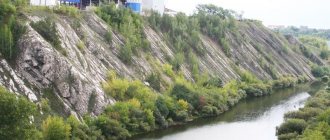
The Oka is the most popular river, literally the “heart of Rus'”. It is along its banks that you can see the Rus' that it was many centuries ago. The Oka belongs to the right tributaries of the Volga, standing out noticeably for its size. By the way, there are those who believe that it is the Volga that flows into the Oka, and not vice versa. The right side of the Oka is not replete with forests, but it is full of ravines, and on the left side you can see sandy terraces and a chain of pine forests.
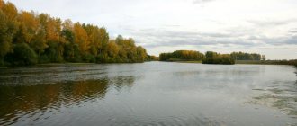
Pra is the left tributary of the Oka, a luxurious water artery in central Russia. This small river is quite popular among rafting enthusiasts. The river flows through the graceful territory of the Meshchera Lowland and therefore attracts many lovers of water tourism. You will be able to enjoy the view of stunning coniferous forests and also admire the high sandy shores. Pra is also distinguished by convenient parking for travelers. This route is suitable for everyone, including beginners. Adults can take children over 6 years old with them.
Climate
The climate of the region, located in the temperate continental zone, is temperate continental with warm summers and moderately cold winters. The amount of total solar radiation arriving at the surface of the earth within the region increases from north to south from 90 to 95 kcal/cm2 year.
Winter. The average temperature of the coldest month - January - decreases from west to east from -10.50C in the Mikhailov area to -120C on the border with the Republic of Mordovia. January isotherms, as on the Russian Plain as a whole, are elongated in the meridional direction. This is due to the fact that in winter heat is carried to the Russian Plain from the Atlantic. In the southwestern, most elevated part of the region, average January temperatures are relatively low, up to -110C – -11.20C. The effect of lowering temperature is related to altitude.
Summer. The average temperature of the warmest month – July – increases from northwest to southeast from +18.50C to +19.50C. The lowest values of average July temperatures, as in January, are observed in the relatively elevated southwestern part of the region, which is associated with a decrease in temperature with height. The average annual air temperature is positive. In the northern regions of the region it is slightly below +40C, in the southern – more than +40C. The duration of the frost-free period on average ranges from 134 days in the northern part of the region to 150 days in the southern part.
The annual amount of precipitation in the region ranges from 700 mm in the northern part to 600 mm or less in the southwest of the region. The northern part of the region, located on the left bank of the Oka and the right bank of the Moksha, is characterized by excess moisture (precipitation exceeding evaporation). To the south of Ryazan, moisture becomes insufficient.
The distribution of precipitation throughout the region is uneven throughout the year. During the warm period, 70% of the annual precipitation falls in most of the region; in the south this figure can be even higher. Most precipitation occurs in July, the minimum amount occurs in March-April. Thunderstorms are frequent at the beginning and until mid-summer, but August is usually dry and hot. The number of days with snow cover ranges from 136 in the south to 140-145 in the north and northeast. The snow thickness in the north reaches 35-50 cm, in the south it is almost two times lower - 27-31 cm. Snowstorms are frequent from December to February. The Ryazan region is characterized by the most dangerous natural phenomena: spring floods, peat fires and strong winds.
Water resources
Rivers. The rivers of the region belong to the basins of the Caspian and Azov seas. Most of the Ryazan region is drained by the river. The Okoya and its tributaries belong to the Caspian Sea basin, the smaller one is located in the south and southwest, drained by the river. The Don and its tributaries belong to the Azov Sea basin. In total, there are 895 rivers in the region with a length of more than 2 km, including 257 with a length of more than 10 km and a total length of 6652 km.
The Don River runs along the border of the region in two sections. In the south of the region, the Don basin includes the rivers Polny Voronezh, Lesnoy Voronezh and Stanovaya Ryasa. In the southwest of the region, about 15 small rivers flow directly into the Don - Kochurovka, Rozhnya, Kruglianka, Panika, etc.
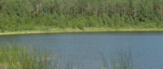
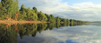
The main water artery of the region is the Oka River, the largest and most abundant right tributary of the Volga. The river originates in the south of the Oryol region. Its length is 1,478 km, of which 489 km are within the Ryazan region. River basin Oka belongs to 850 rivers and streams with a total length of 9886 km, including 14 rivers with a length of more than 10 km. The largest right tributaries of the Oka within the region are the rivers Moksha, Pronya, Para, Istya, Vozha; left - Unzha, Gus, Pra. The rivers have mixed feeding with a predominance of snow. The rivers freeze at the end of November - beginning of December, and open at the end of the first - beginning of the second ten days of April. The water level in the Oka rises by 5-6 m, in some years by 9-11 m. At the same time, the water floods the floodplain.
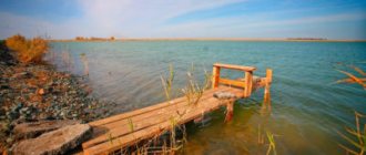
Lakes. There are 2838 lakes in the region with an area of more than 0.2 hectares. Their total area is 245.8 square meters. km. Of these, 1,400 lakes have an area of more than 1 hectare, 1,438 are less than 1 hectare. 12 lakes have an area of more than 1 sq. km. The largest of them is Lake Velikoye with a surface area of 20.7 square meters. km. The deepest is Beloe near the village of Beloe, Klepikovsky district (according to various sources, depth is from 45 to 56 m).
Swamps. Within the region there are about 1230 swamps with a total area of about 92.5 thousand hectares.
The overwhelming majority of the swamps are concentrated in Meshchera.
Ryazan Oblast
Ryazan region is a federal subject in the southwest of the European part of Russia. The region is located in the basin of the middle and, partially, lower reaches of the river. Oka, in the subtaiga and forest-steppe natural zones. In the north of the region there is the Meshchera Lowland with many small lakes, in the west there are spurs of the Central Russian Upland.
The Ryazan region is part of the Central Federal District. The administrative center is Ryazan.
The region's territory is 39,605 km2, the population (as of January 1, 2017) is 1,126,739 people.
Surface water resources
The watershed between the Black Sea-Azov and Caspian basins passes through the Ryazan region - most of the region’s water bodies belong to the Volga basin, a smaller part to the Don (97% and 3% of the territory, respectively).
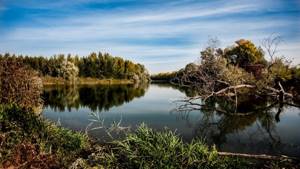
The river network of the Ryazan region is represented by 895 rivers with a total length of 10,255 km (the density of the river network is 0.26 km/km2), most of which are small rivers and streams. The rivers of the region are predominantly flat, characterized by low slopes, low flow speeds, well-developed floodplains and significant tortuosity. The rivers of the Ryazan region are characterized by mixed nutrition with a predominance of snow. The rivers of the region belong to the Eastern European type of water regime, they are characterized by high spring floods, summer-autumn low water, interrupted by rain floods, and low winter low water. The rivers freeze at the end of November and open at the end of March - beginning of April. The largest rivers of the Ryazan region are the Oka with tributaries of the first and second order - Moksha, Proney and Tsnoi (the left tributary of the Moksha). The floodplain areas of the Pra and Oka rivers are included in the list of wetlands of international importance under the Ramsar Convention.
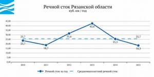
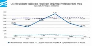
The average long-term river flow is 25.7 km3/year. In 2015, river flow in the Ryazan region amounted to 18.3 km3/year, which is 28.79% lower than the long-term average. Below is the dynamics of river flow in the Ryazan region from 2010 to 2015.
According to the Institute of Lake Science of the Russian Academy of Sciences, on the territory of the Ryazan region there are more than 4,300 lakes and artificial reservoirs with a total area of more than 220 km2 (lake content 0.56%), including about 900 lakes with an area of more than 0.01 km2 and a number of smaller lakes. In the north of the region, predominantly glacial lakes are common, in the central and southern parts there are small floodplain lakes in the floodplains of most large rivers, primarily the Oka. There are small karst lakes. The largest lake in the region is Lake Velikoye in the upper reaches of the river. Pry with an area of 20.4 km2. The largest artificial reservoirs in the region are located on the river. Prone - Pronsky reservoir on the border of the Ryazan and Tula regions and the Novomichurinskoye reservoir.
Swamps and wetlands occupy 1.4% of the territory of the Ryazan region - 554 km2.
The area and number of lakes and artificial reservoirs, swamps and wetlands are variable; they depend on natural (water regime, climatic phenomena, swamping, meandering, etc.) and anthropogenic (drainage of territories, creation of new artificial reservoirs, etc.) factors.
Groundwater resources
The forecast groundwater resources of the Ryazan region are 3918 thousand m3/day (5.29% of the total volume of forecast groundwater resources in the Central Federal District and 0.45% in Russia). Groundwater reserves in the region as of January 1, 2015 amounted to 556 thousand m3/day, which corresponds to a degree of knowledge of 14.19%.
According to data as of January 1, 2015, 239.1 thousand m3/day were produced and extracted from underground water bodies of the Ryazan region during the year, including 94.6 thousand m3/day from the fields. The degree of development of groundwater reserves is 17.01%.
Provision of population with water resources (according to 2015 data)
The provision of the region's population with river flow resources is 16.193 thousand m3/year per person, which is lower than the Russian average (31.717 thousand m3/year per person), but higher than the indicator of the Central Federal District (2.082 thousand m3/year per person).
The provision of predicted groundwater resources is 3.467 m3/day per person, which is also lower than the Russian average (5.94 m3/day per person), but higher than the figure for the Federal District (1.894 m3/day per person).
Below is the dynamics of provision of the population of the Ryazan region with river flow resources in 2010–2015.
Water use (as of 2015)
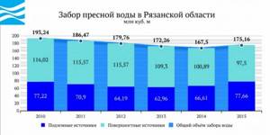
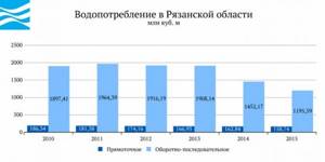
The intake of water resources from all types of natural sources in the Ryazan region is 175.16 million m3, the shares of intake from surface and underground sources are comparable (55.66% and 44.34%, respectively). Below is the dynamics of fresh water intake in the Ryazan region in 2010–2015.
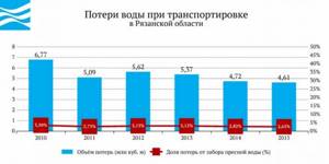
Total water losses during transportation in the Ryazan region are 4.61 million m3 or 2.63% of taken water, which is lower than both the federal district figure (5.39%) and the Russian average (11.02%). Below is the dynamics of water losses during transportation in the Ryazan region in 2010–2015.
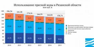
Direct-flow water consumption – 162.84 million m3. 158.74 million m3. Most of the water was used for drinking and domestic purposes, as well as for industrial needs (43.53% and 32.03%, respectively), agricultural water supply accounts for 1.88%. Below is the dynamics of water consumption in the Ryazan region in 2010–2015.
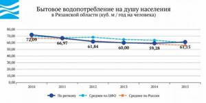
Domestic water consumption per capita in the Ryazan region is 61.145 m3/year per person, which is higher than both the Russian average and the federal district indicator (56.205 and 59.952 m3/year per person, respectively). Below is the dynamics of domestic water consumption per capita in the region in 2010–2015.
The volume of circulating and re-sequential water consumption in the region is 1195.59 million m3 or 88.28% of the total water consumption in the region. Below is the dynamics of direct-flow and recycling and re-sequential water consumption in the region in 2010–2015.
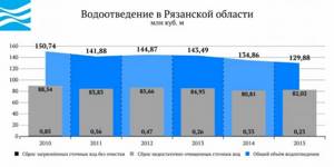
Discharge of wastewater into water bodies of the Ryazan region is 129.88 million m3, of which 36.67% is conditionally pure and standardly treated wastewater, the volume of polluted and insufficiently treated wastewater is 63.33%. The region generates 2.57% of the total volume of polluted and insufficiently treated wastewater of the district and 0.57% of the country. Below is the dynamics of water disposal in the region in 2010–2015.
Water quality (based on 2014 data)
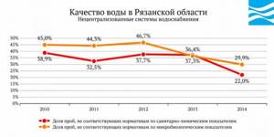
In 2014, in the centralized water supply systems of the Ryazan region, non-compliance with standards for sanitary and chemical indicators was recorded in 14.5% of samples taken, and for microbiological indicators - in 4.3% of samples. In non-centralized water supply systems, the quality of 22% of samples for sanitary-chemical indicators and 29.9% of samples for microbiological indicators did not meet the standard. Below is the dynamics of the corresponding indicators in the region in 2010–2014.
Water management
The Ryazan region is in the area of responsibility of the Moscow-Oka Basin Water Administration of the Federal Agency for Water Resources of Russia.
The functions of providing public services and managing federal property in the field of water resources in the region are carried out by the Water Resources Department of the Moscow-Oka BVU in the Ryazan Region.
The powers in the field of water relations transferred to the constituent entities of the Russian Federation, the functions of providing public services and managing regional property in the field of water resources in the region are carried out by the Ministry of Natural Resources and Ecology of the Ryazan Region.
The state program “Development of the water management complex and improvement of the environmental situation in 2015–2020” is being implemented in the region - a regional program, the objectives of which include increasing the operational reliability of hydraulic structures, ensuring the protection of the population and economic facilities from the negative impact of water, and reducing the negative anthropogenic impact on water bodies, development of a system of state monitoring of water bodies, environmental rehabilitation of water bodies, increasing the efficiency of state environmental supervision and state environmental monitoring, maintaining the Red Book of the Ryazan region, development of a system of environmental education and education of the population and other tasks.
When preparing the material, data from the State reports “On the state and protection of the environment of the Russian Federation in 2015”, “On the state and use of water resources of the Russian Federation in 2015”, “On the state and use of land in the Russian Federation in 2015”, were used. “On the environmental situation in the Ryazan region in 2015”, collection “Regions of Russia. Socio-economic indicators. 2016". The ratings of regions for surface and underground water resources do not take into account the indicators of federal cities - Moscow, St. Petersburg and Sevastopol.
Vegetable world
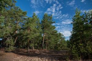
At the beginning of 2021, the forested area was 950.1 thousand hectares. The forest cover of the region was 24.0%. The main part of the forests is located in the northeastern part of the region and is included in the zone of coniferous-deciduous forests. In the southwestern half of the region, forests are located in the forest-steppe and steppe zones.
Broad-leaved forests include such tree species as ash, sycamore and Norway maples, linden, and oak. The undergrowth consists of bird cherry, rowan, buckthorn, euonymus and forest honeysuckle. In the grass cover you can find the types of grasses common to the central zone: perennial forest grass, bluebell, violet, wild strawberry, yellow greenberry, oak manna, male shield, etc. In coniferous forests, spruce and pine trees predominate; various types of shrubs are found - blueberries, lingonberries, cranberries , blue lightning.
A significant part of the forest cover is birch and oak forests. Of the meadow and field plants, the most common are meadow clover, alfalfa, fescue, timothy, meadow geranium, bluebell, brome, etc. In the southwest of the region, vegetation characteristic of the steppe zone is widely represented: feather grass, thyme, wheatgrass, yarrow, wormwood. In total, about 1,300 plant species are currently registered in the Ryazan region, of which over 100 are listed in the region’s Red Book.
Mysterious and anomalous places
Like all of Russia, the Ryazan region is full of mysterious and sinister places. Some of them have already been solved, but many still pose a mystery to humanity.
Fefelov Bor
- Coordinates: 54.703301, 39.670950.
The forest on the outskirts of the Kanishchevo microdistrict, preserved from the Stone Age, is considered one of the most anomalous places not only in the Ryazan region, but also in Russia. Strong magnetic fluctuations are observed here, people's heartbeat increases and an anxious state arises.
The trees frozen in a strange dance fit perfectly into this frightening coloring. Everyone who enters this forest notes the presence of some alien energy. Many are sure that these are the souls of people buried in the Kanishchevsky burial ground.
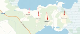
Dancing forest in Tarnovo
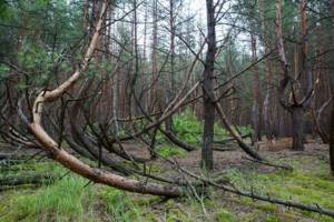
- Coordinates: 54.291719, 39.648329.
The forest in the Shilovsky district is most often called “drunk.” The trees here are curved in the most bizarre way. But, surprisingly, this only applies to pine trees. Other breeds grow as usual. It is still unknown why this anomaly arose, but it is absolutely certain that it exists.
The “Drunken Forest” is considered one of the most mysterious places in the region and attracts the attention of not only ordinary tourists, but also thrill-seekers. Frequent visitors here are also ufologists who try to find a paranormal explanation for the dancing trees.
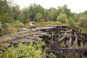
Devil's Bridge in Kiritsy
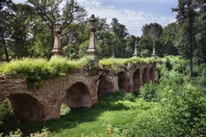
- Coordinates: 54.292137, 40.354453.
Estate complex in Kiritsy, owned by S.P. von Derviz, was a magnificent sight. Five architectural styles that mixed and became one gave it mystery and charm. The stone bridge over the ravine formed in the bed of the Kiritsa is the main pearl of the estate. The entrance to it began with a massive gate. The central part was distinguished by four obelisk lanterns. They also mark the beginning and end of the bridge.
If rumors are to be believed, this bridge is also an anomalous place. Sometimes you can meet the ghost of a young girl here. According to legend, it was built by von Derviz specifically for meetings with a local peasant girl. But love is not eternal and soon Sergei Pavlovich got tired of her love. When she found out about this, she threw herself into the water in despair. Since then, the bridge has been called the Devil’s, and the ghost of a young peasant woman is said to come to the meeting place.
Watch oak in Sapozhkovsky district
- Coordinates: 54.016476, 40.855953.
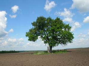
Once upon a time, such lonely trees were used as sentinels. From their top it was very convenient to observe the approach of the enemy. Today, this ancient tree is believed to have the ability to grant wishes. To do this, you just need to make a wish and leave a ribbon near the oak tree, but do not tie it on the branches, so as not to damage the tree.
Kursha-2
- Coordinates: 54.938963, 40.556689.
This name was given to the village of lumberjacks, built at the beginning of the 20th century. People from all over Russia began to flock to it to develop forest areas. Today, on the site of the once prosperous city there is only a mass grave and a memorial plaque. The fire, which broke out in the summer of 1936, claimed the lives of 1,200 people.
These were almost all residents of the city, military personnel who helped put out the fire and prisoners working in logging. Only a few dozen people managed to escape. Since then, Kursha-2 has been considered one of the most sinister places in the Ryazan region.
Starozhilovsky stud farm
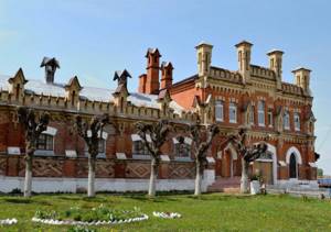
- Address: Konezavodskaya st., 4A, working village Starozhilovo.
It was built at the end of the 19th century by S. P. von Derviz. Initially, only Arabian horses were bred here. The livestock numbered about 2,700 heads. Later they began to raise heavy draft horses and horses of the Orlov-Rostopchin breed. During the Civil War and the First World War, the population decreased significantly, and during the Second World War it completely died.
The horses drowned during the evacuation across the Oka River. However, the factory survived and continued its breeding work, because horses were the main draft force at that time. Today the plant is open to visitors. Here you can ride horses or take a tour of the local museum.
Do not miss the sights of other cities of the Ryazan region - Spas-Klepikov and Gus-Zhelezny
You may also be interested in interesting places in the regions neighboring the Ryazan region - the Moscow region, Vladimir, Tula and Lipetsk regions.
Leaving the Ryazan region, you feel regret that you didn’t have time to see everything. And at the same time you understand that it is impossible to do everything at once. With the realization of this comes understanding and joy that now there is a reason to someday return to this hospitable region and close the gaps in your tourist list.
Animal world
The territory of the Ryazan region is inhabited by 67 species of mammals, 279 species of birds, 6 reptiles, 10 species of amphibians, 25 species of cyclostome fish and several tens of thousands of invertebrates.
The Ryazan region is inhabited by: elk, wild boar, wolf, fox, brown hare, beaver, squirrel, ferret; of rodents - gophers, hamsters, jerboas; Birds include teal, mallard, gray duck, etc. These include geese, swans, wood grouse and black grouse, owls, woodcocks, quail, partridges, etc. 80 species of fish are registered in the reservoirs of the region. Commercial fish species of the river. Okies are pike, bream, asp, perch, pike perch, roach. The most common are crucian carp, carp, roach, silver bream, ide and rudd, catfish, tench, blue bream, sabrefish, etc.
At the moment, 281 species of animals are listed in the Red Book of the region.