Etymology of the name
Often a mistake is made in the name of a river by placing the emphasis in the word on the second syllable: SukhOna. Correctly say: SUkhona. This is explained by the etymology of the name.
In the 9th-15th centuries, a busy Northern trade route from Veliky Novgorod to Zavolochye, which was called Zavolochsky, ran along the river. Along the Mologa, Volga, Sheksna, across Lake Kubenskoye, along the Sukhona to the Northern Dvina, boats with fabrics and weapons, items made of copper, glass, silver and gold walked. They brought back furs, walrus ivory, leather, flax, honey, and lard. To get from one river to another, ships had to be dragged overland, i.e. drag on dry ground.
There is another version. “Sukhona” in Old Church Slavonic means “dry bottom”. In the summer, the river became very shallow, and in some areas the ships had to be literally dragged along the bottom. This continued until the “Famous” dam, which had a shipping lock, was built in 1834. It was erected in the place where the Sukhona flows from Lake Kubenskoye, and maintains the water level in the river, preventing it from becoming shallow in the summer.
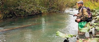
Features of fishing on the Sukhona
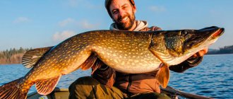
For fishing, try to choose a place in the lower part of the Sukhona. It is better to position yourself in areas adjacent to oxbow lakes, i.e. near the pits. If you catch bream at the exit of the river, you will be able to catch a large fish no earlier than 11 am.
Experienced fishermen advise using a worm as bait. Maggot is less effective in this area. A grasshopper or any animal food is also considered a good bait.
It is recommended to follow a special bait tactic - scatter it at least every 30 minutes. Such baits are good for catching silver bream and large bream.
The best time for fishing is dawn or evening. Try to choose a less windy day. With autumn cold snaps, catching ide becomes problematic; it goes to deeper places.
Fishing for bream has its own characteristics: it is better to catch it from the shore with long casts. The most effective way is to lure this fish from a boat using long-distance fishing. Here you can also use crushed cookies or fruit flavoring as a top dressing.
Traveling along the Sukhona
Traveling along the largest and most significant river of the Russian North takes several days, and we will take a virtual walk and see what the Sukhona River of the Vologda Region looks like on the map.
Source
Sukhona is born from Lake Kubenskoye. It is in fact a reservoir - a reservoir of fresh water, which is used by residents of the surrounding areas.
About 30 rivers and rivulets flow into the lake, but only two flow out - Sukhona and Bolshoi Puchkas. Bolshoi Puchkas separates from Lake Kubenskoye 7 km southwest of the Sukhona, winds for a long time through flat terrain and merges with the river eight kilometers from its source.
Until now, scientists cannot agree on the status of Big Puchkas. Some consider it a tributary. Others argue that the Sukhona is one of the few rivers in Russia that has two sources.
Upstream
In the upper reaches, the Sukhona flows to the southeast, after the village of Kalitino it gradually turns south.
To the mouth of the Lezha, the river makes its way through a low-lying valley; a wide treeless floodplain is formed along the riverbed, representing water meadows or wetlands. In the spring, during floods, many kilometers of floods form here.
After the high water has receded, the width of the river in the upper reaches is no more than 200 meters.
Middle current
At the confluence of Vologda, the river bends and heads to the northeast, without changing its direction until the very mouth.
If in the area from the confluence of the Lezhi to the village of Shuiskoye the banks are still flat and rise gradually, then further to the mouth of the Totma they grow up to 15 meters in height, the forest thickets approach the very edge of the water, and the bed of the Sukhona narrows to 150 meters.
In spring, at the mouth of Lezha and Vologda, you can observe an interesting natural phenomenon. Both rivers fill the Sukhona so much during high water that it begins to flow in both directions: part of the water turns back and ends up in Lake Kubenskoye, while the other continues to flow in the direction of Veliky Ustyug. This natural phenomenon lasts an average of two weeks every year.
The river in its middle reaches is replete with rifts and rapids – “overshoots” in the local dialect – as well as islands.
There are 130 rapids in total on the Sukhona. The most famous: Kopytovsky, Cow Ford, Koryto, Harrow, Popoluzha, Sturgeon, Rzhanik, Zhelezny, Zhidyatino.
Stone Elk
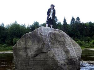
9 kilometers downstream from Totma, above the surface of the Sukhona, the Elk stone rises, outwardly similar to the head of an elk. Its dimensions are 8x4 meters. At 2 meters it is visible above the water, at 2 meters it goes under water. They say that on the stone itself there is a depression in the form of a hoof print of this animal.
The stone also has another name – the Tsar’s Table. According to legend, Tsar Peter I himself deigned to dine on it during one of his travels. Theoretically, this is possible, as up to 10 people can be accommodated here.
Nearby is a smaller stone called Cow.
Grandfathers Island
Not far from Totma (7 km upstream) there is a large island of Dedov, covered with taiga forest. The length of the island is 1.5 km, width 500 m. It rises 10 meters above the surface of the water and is never flooded during high water.
The islands of Babii and Vnukov are located nearby, but they are not so large.
Downstream
From Totma, the Sukhona continues its journey in a northeastern direction to Veliky Ustyug, where it merges with the Yug River. At the place where they unite, the Northern Dvina River is born. Its name literally means "double".
In the lower reaches of the river, the bedrock banks become even higher and approach the water closer, and the channel narrows. The flow speed in some areas increases to 5 m/s, which is comparable to the speed of mountain rivers.
Below the village of Poldarsy, the river flows through a canyon, which is a tectonic outcrop. The height of the steep banks reaches 80 meters.
The banks are dominated by forests, which occupy about 70% of the entire catchment area.
The width of the channel ranges from 100 to 150 meters, reaching 400 meters in some areas.
Vaskin's key
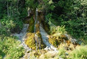
Vaskin Key waterfall.
A landmark of the river is the small Vaskin Key waterfall at the 87th kilometer from the mouth, which flows from a cleft in the coastal rock and has not dried up for several hundred years.
The spring originates in the deep Devil's Lake, which is located nearby, and comes to the surface from the steep bank of the Sukhona.
There is such a legend about the appearance of the waterfall: a devil named Vaska, in his anger, hit the cliff with his fist and split it. From there he hammered the key, later named Vaskin.
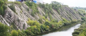
Opoki
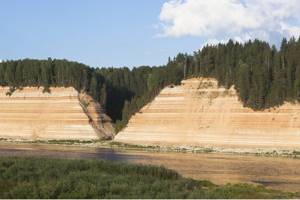
Opoki.
70 km from Veliky Ustyug, near the mouth of the Strelna River, near the village of Priluki, there is the most famous and dangerous rocky threshold Opoki, 1.5 km long.
The word "opoka" means "rock" in the local dialect. Above the threshold there really is a sheer cliff consisting of layered rocks: limestone, dolomite, marl. Its height is 60 meters, which is comparable to a 20-story building.
Worship cross
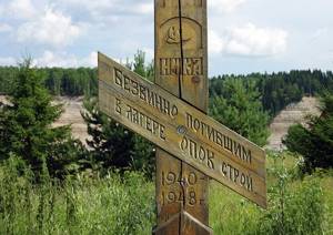
Monument to the dead. Opoki. Sukhona River.
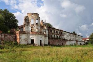
In Opoki the river has a sharp bend, forming a sharp elongated cape, at the end of which there was a Gulag zone. In the harsh climate between 1943 and 1947, 1,100 prisoners built a navigable dam with a lock here.
The results of their titanic efforts were destroyed by ice drift and washed away by floods in 1947. The remains of the failed structure are still visible from the water. Now on the site of the camp there is a worship cross with the inscription “Those who suffered without guilt.”
Geyser
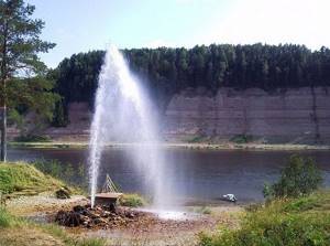
Geyser on the Sukhona River.
About a kilometer from Opok, on the right bank of the Sukhona, a geyser shoots out of the ground, attracting the attention of tourists. The jet is forcefully ejected from a well drilled in 1941 as a result of geological surveys. The water in the source is slightly mineralized and has a brackish taste.
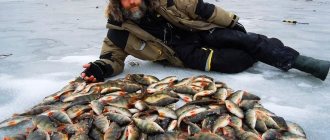
Where can you go fishing for free?
The reservoirs of the Vologda region do not experience much fishing pressure. There are clean shores and clear water with a huge variety of fish. In winter there is real freedom here.
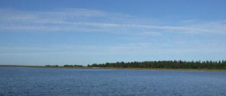
Lake Onega
It ranks second in size in Europe. The cleanest water - there are no industrial facilities or populated areas on the banks. About a hundred rivers and streams flow into the lake. Only one river flows out - the Svir. The lake is deep. The bottom topography is varied.
The lake is home to 47 species of fish. In addition to the usual species, there are:
- lake trout (up to 2 kg);
- palia;
- sterlet;
- grayling.
The size of the sterlet reaches 15 – 18 kg. Specimens weighing 6-7 kg are more often caught on donka.
The lake is home to Onega salmon. On trolling gear they come across sizes of 2 – 5 kg. Very rare, but still found is the river eel.
Sukhona River
The largest river and the main water artery of the Vologda region. The length of the river is about 500 kilometers. Periodically there are rapids, islands and rifts.
The Sukhona gained the greatest popularity among fishermen in the middle and lower reaches. There are more white fish than predatory ones.
Roach , pike, perch, chub, asp are caught . Huge population of bream . Ide weighing up to 0.5 kg is common. Most often, ide and bream are caught with bottom fishing rods. They look for ide near rocky shores or underwater piles of petrified clay. Bream is found everywhere, the largest ones stick to the bottom with the peculiarities of the relief and exits from the pits.
Trophy specimens of pike, which are often found in Sukhona, are most often found on riffles and areas with underwater or surface boulders.
Numerous oxbow lakes attract fish.
The gear used for fishing does not require large expenditures. A bottom and float fishing rod with the possibility of long casting is sufficient. At night they catch carp , pike perch, and catfish .
When catching white fish from a boat, long-distance fishing is used. Natural baits are the most commonly used. You can select fresh peas, pearl barley, grasshopper, and river shellfish meat. Local residents most often use wheat boiled with thyme as bait.
White Lake
Small but huge in area (1284 sq. km with a length of 43 km and a width of 32 km) lake. The average depth is 7 meters, the pits are up to 15 meters. There are only 4 settlements on the shores of the lake. The lake is replete with magnificent scenery.
There are 29 species of fish in the lake. Excellent fishing for zander and bream . The fish that are caught are saberfish , asp, bersh, perch, ruffe, roach, pike, ide, and tench . There are such rare species as sterlet, vendace and smelt .
It is believed that the northern shore of the lake is more suitable for fishing. Here is the delta of the Kovzh and Kama rivers, and many streams. This coast is the farthest from industrial facilities and shipping routes of the Volga-Baltic Canal
River South
Right tributary of the Northern Dvina. The total length is 574 km. It flows through the Vologda region in two sections:
- From the source in the Severouvalskaya Upland to the Kichmengsky Town. In the initial sections it winds a lot.
- From the village of Slizovitsa to the city of Veliky Ustyug.
In the river they catch taimen, pike, burbot, salmon, ide, perch, bream, and gudgeon.
Coming to the Vologda region for fishing, you can get real pleasure. The variety of fish stocks can satisfy the needs of any angler. There are also plenty of fishing options - from a boat, from the shore, with predatory or peaceful fish, on a donkey, with a spinning rod, a float - whatever your heart desires.
Shipping
The river is navigable along its entire length from the Znamenity lock to Veliky Ustyug. Only occasionally in the summer, when the Sukhona becomes very shallow, is transportation along it temporarily stopped.
Back in the 9th century, a trade route ran along the Sukhona. Over the next few centuries, it was a significant transport and trade artery connecting Rus' with the North - the White Sea and the Northern Urals.
In 1868, Sukhona and Sheksna, belonging to the Volga basin, were united by the North Dvina Canal. Along the banks of the river, every 5 km, there are pillars indicating the distance to the mouth, which reminds of the active period of navigation.
The extinction of villages, which began in the last century, led to the fact that passenger transportation along the river ceased, leaving only cargo traffic.
History of the Sukhona River in the Vologda Region
The name Sukhona is of Slavic origin. Sukhodon means “river with a dry bottom”, “dryness”. Since the fifth millennium BC, people have settled on the banks of the river. The Vex settlement complex was located at the confluence of the Sukhona River and Vologda and existed until 1339. In the 11th century, Russian settlers appeared on the Sukhona.
The river is located on the waterway to Central Russia, so it has long been of great transport importance. Few rivers in Russia have taken on heavy hydrological work associated with improving navigation for a long time.
The Sukhona River is one of them. Back in 1278, the Belozersk prince ordered the steep bend near the source to be straightened.
In 1339, the bend near Lezha was straightened. But the main problem for navigation along the Sukhona has always been rocks, rapids and shallowing of some areas.
And here's what you need to know: Fishing tackle with delivery by Russian Post to any region
In the summer it became shallow there, making navigation possible only with the help of peasants dragging loads along the riverbed. In 1834, a dam was built at the source of the Sukhona River.
She helped maintain the water level at the proper level in the summer.
Largest tributaries
The Sukhona River has more than a hundred tributaries, large and small, many of them are minor forest streams that cannot always be identified on the map.
The most famous right tributaries:
- Vologda;
- Lying down;
- Howl;
- Ledenga;
- Cookies;
- Old Totma;
- Strelna.
Left tributaries:
- Shobolka;
- Glushitsa;
- Dumpling;
- Dvinitsa;
- Tsareva;
- Uftyuga;
- Upper and Lower Erga.
River hydrology
The Sukhona River is fed by snow. The flood usually occurs in April and lasts until mid-summer. In the upper reaches, spills sometimes form for many kilometers. The Sukhona usually becomes covered with ice in November (the average current is in December), and ice breaks up in April.
The flow of the river is usually divided into three sections: upper, middle and lower. Let's take a closer look at them.
- The upper section lasts to the mouth of Vologda. The current on it is calm and measured. The banks are low, treeless, covered with water meadows. The width of the river in the upper reaches is approximately 200 meters.
- The middle course of the Sukhona goes to the city of Veliky Ustyug. Here the banks become higher and narrower. The forest approaches the riverbed. The current speeds up, rapids and riffles appear.
- The lower section begins after the city of Totma. The banks of the Sukhona River are the narrowest here, in some places up to 80 meters. The current is the fastest. There are a large number of rapids in the Totma area. The most famous of them are Koryto, Zhidyatino, Opoksky Roll, Kopytovsky.
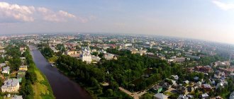
Largest cities
On the Sukhona are Sokol, Totma and Veliky Ustyug.
Sokol is the first city on the Sukhona, if you look from the source. In the 17th century it was mentioned in documents as the settlement of Sokolovo. At the end of the 19th century, the Sokol pulp and paper production plant was opened here, which gave its name to the city, which grew around the factory and absorbed several surrounding villages.
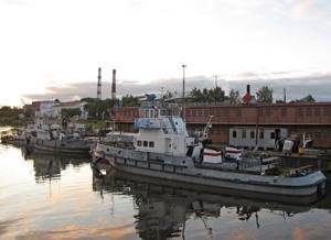
Port on the Sukhona River in the city of Sokol, Vologda region.
Sokol is the only port remaining on the Sukhona, which also serves as a transshipment base for bulk cargo and is engaged in shipbuilding and ship repair. The port management associates the development prospects of the enterprise with the construction of floating bridges, pontoons and floating berths.
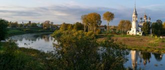
Totma is the second city on the Sukhona, located 215 km from Vologda, where the Pesya Denga tributary flows into.
In the old days it was called Totemskaya salt or Usolye because of the nearby salt mines. The word “Totma” itself is translated as “damp land overgrown with fir trees.”
At different times, V. Korolenko, A. Lunacharsky, M. Molotov, I. Dzhugashvili (Stalin) and other famous figures, writers, and publicists visited the city.
"Spaso-Sumorin Monastery" in Totma, Vologda region.
Totma has the official status of a historical city of Russia; there are many monuments of federal and regional significance.
Veliky Ustyug is the last city on the river. He played a vital role in the economy of the region. In the 16th century, the Tsar appointed Ustyug an oprichnina city. According to some sources, it was Ivan the Terrible who gave him the epithet Great. Until the 18th century, Ustyug flourished; over time, the direction of trade routes changed, and it lost its former importance.
A remarkable event occurred in 1999, when the city was declared the birthplace of Father Frost. So the lord of snow and cold received official registration, and Veliky Ustyug began to develop as a tourist attraction.
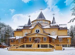
Residence of Father Frost. Veliky Ustyug.
The residence of Father Frost is located 12 km from the city - it is a fairy-tale forest where everything is considered magical: a tower with 12 rooms; a forge, a winter garden, ice figures, a children's playground and many attractions. Even the trees and paths in the forest make us remember the fairy tale.
The number of guests who come here annually amounts to hundreds of thousands, and millions of letters from children arrive.
Ecology
Human economic activity pollutes the waters of the Sukhona. Below Cherepovets, Sokol, Vologda, which are large industrial centers of the region, the environmental situation is considered unfavorable.
Since ferrous metallurgy is developed in the Vologda region, Sukhona is forced to receive more than 170 thousand cubic meters of untreated industrial wastewater every day.
In 2007, Pelshma, the left tributary of the Sukhona, was recognized as the dirtiest river in the Northern Dvina basin due to the fact that the Sokolsky pulp and paper mill discharges wastewater into it.
Traditional logging also played a role in aggravating the unfavorable environmental situation. Since the Sukhona was used for rafting for hundreds of years, its bottom is covered with sunken logs. Due to the decomposition of organic woody debris, there is not enough oxygen in the water, especially in winter, and the flora and fauna of the river suffer as a result.
In the area of Veliky Ustyug, the Sukhona riverbed is currently being cleared and deepened.
Flora and fauna
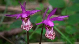
Russian orchid.
In the lower reaches along the river there are pine and mixed taiga forests, and closer to the source there are birch groves.
Along the banks of the Sukhona there are rare plant species listed in the Red Book of Russia, for example: Russian orchid - calypso, clematis vine.
Game birds include black grouse, hazel grouse, and partridge.
The fauna world is represented by valuable fur-bearing animal species, such as ermine, ferret, marten, raccoon, fox, lynx, otter, etc.
Alloy
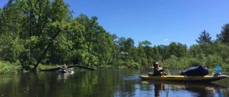
Those rafting along the Sukhona need to be prepared for any surprises that the rifts and rapids have in store for them. But the journey is worth the risks.
Tourists will find many places of interest, as well as fishing, picking mushrooms and berries in the parking lots. It’s better to immediately plan a multi-day hike so that you can slowly experience all the beauty of the northern latitudes.
Kayaking and rafting usually begins at the village of Shuiskoye, which is located 146 kilometers above Totma, and ends at the Malaya Northern Dvina, since sailing further does not make sense due to active shipping, the large width of the riverbed and uninteresting monotonous banks.