- August 20, 2018
- Directions
- Valery Savelyev
According to scientific data, the Don River appeared on Earth several hundred thousand years ago. This is one of the largest rivers of the southern Russian steppes, with which the history of Russia is closely connected. Let's consider the questions of where the Don flows, where it originates, and what role it plays in the country's economy at the present time.
Where did the name of the Don River come from?
Revealing the questions of where the Don flows and where it begins its flow, it is interesting to first find out where the river got its real name.
The Don is one of the oldest rivers in Russia. The ancient Greeks called this river Tanais. According to their ideas, it divided Europe and Asia. Then the river was the habitat of the legendary Amazons. Mentions of the battles of warlike women can be found in Russian epics.
The river received its current name thanks to the Iranian tribes that inhabited the northern coast of the Black Sea. In their language, the word “don” means “river”. Interestingly, as it is commonly called in our country, it is not the only river on the planet that has this name. Its younger namesakes are found in England in the County of York and in Scotland in the County of Aberdeen.
Title and history
The European part of Russia has many water resources. Rivers occupy the bulk of them and are of primary importance. The Don is one of the largest waterways in this region.
In prehistoric times there was no division between the Azov and Black Seas. Therefore, the river with the future name Don flowed into the latter. Further geological processes changed the geographical map, where the current position of the river was determined.
The first ancient mention of the name of the object sounded like the Amazon River. In ancient times of the 3rd century BC. e. the name changed to the ancient Greek Tanais, after the name of the large colony created by the Greeks. There is information about another name for the river - Girgis. The Normans had another name - Vanaxville.
The modern name comes from the Aryan root danu (dew, drops, river). The Russian version of the root, with the modern letters of the word, passed from the Scythian-Sarmatian danu to the Ossetian word don (water, river). The name Donets also has Scythian roots in a variation of the Old Russian diminutive from the word Don. Therefore, many Don tributaries have names from two components: Linden Donets, Seversky Donets and others.
In the 1st millennium BC. e. Tanais was a trade route between Scythia and the Greek cities of the Black Sea region. Subsequently, the territory of the Don region belonged to the Huns, Bulgars, Khazars and Pechenegs. From the 13th century was part of the Golden Horde.
In the XIV century. The river established a trade route between the Russian principalities. And from the 16th century. water communication began between the Russian state and the Genoese colonies in Crimea. At the same time, the Don Cossack Army was formed. The modern Don region also left its bright mark on history.
Characteristics of the river
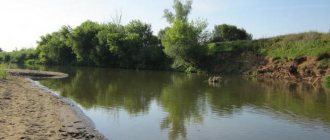
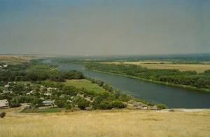
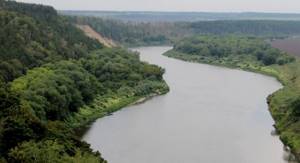
The Don River, flowing in the southern part of European Russia, has a length of 1870 km and is the 6th longest river in Europe. The area of the river basin is 422,000 km2. The left bank of the river along almost its entire length is low, gentle, while the right bank is mostly high and steep.
The main cities through which this river flows are Kalach-on-Don, Volgodonsk, Rostov-on-Don and Azov. The Don has many tributaries; according to general estimates, the number of rivers and rivulets that carry their waters to the Don is more than 5,200, and their total length is approximately 60,100 km, that is, 30 times greater than the length of the Don itself.
The Don is located in the flat part of Russia, and due to its nature, it is usually divided into three parts: the upper, middle and lower Don. The upper part of the river flows along a wide plain from its beginning to the confluence of the Tikhaya Sosna River, located in the Voronezh region. The middle course of the river is located between the confluence with the Tikhaya Sosna River and the city of Kalach-on-Don. In its middle part the Don has the widest channel. Looking at the lower part of the river, you can understand where the Don flows into which sea, since its lower course starts from the city of Kalach-on-Don and ends with the river flowing into the Sea of Azov.
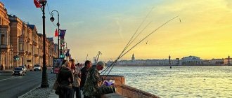
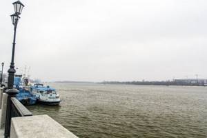
Cruises on the Don
Travel companies in many large cities organize river cruises to Rostov-on-Don. A trip on the route Moscow → Rostov-on-Don → Moscow lasts 22–24 days, similar trips are also carried out from other cities located on the Volga and Kama.
Often the end point of cruises is not Rostov-on-Don, but the cities of the Azov Sea - Yeysk, Azov or Taganrog.
The Quiet Don is the name given to the great river for its slowness and grandeur. Along with the Volga, it has a special significance for Russia - it has been a vital artery since the time of Peter the Great.
Sources, mouth and direction of the Don current
The source of the river is Lake Ivan, located in the central part of the East European Plain near the city of Novomoskovsk, Tula region. In relation to the capital of Russia, the city of Moscow, the lake is located 200 km to the south.
The Don River winds strongly along its entire length. So, from its sources to the city of Korotoyak, the river continually changes its flow direction from north to south, and in its middle and lower parts it flows either east or west.
Which sea does the Don flow into? The river carries its calm waters into the Sea of Azov, where it forms a wide mouth or delta in the Taganrog Bay.
Water shortage
The lack of water in the Don in recent years has had a negative impact on the economy of the regions located along the river, notes Kushnareva from the Rostov region.
“Almost all sectors of the economy - shipping, irrigation, fishing, hydropower and others - directly depend on the hydrological state of the Don River. Currently, the water management situation in the Don River basin is characterized as tense and is due to decreased water availability in the period from 2007 to 2015. In 2011, the influx of water into the Tsimlyansk reservoir (located in the Rostov region - TASS note) amounted to 38% of the norm with an annual volume of only 10.9 cubic meters. km at a norm of 21 cubic meters. km,” she said, adding that recent years have also been “exceptionally low-water.”
In the Voronezh region, the shallowing of the river has led to a sharp reduction in navigation, Vorobyov confirms her words. “There is small shipping, but previously there were a lot of ports in the region in large cities, for example, in Pavlovsk, in Liski. But now they are not working fully,” she explained.
At the same time, according to her, the problem of shallowing the river can be partially solved by centralized, with the involvement of federal funding, work to clear the Don bed. “The region itself cannot do anything about this problem - this is a very large amount of money. Clearing the bed of such a wide river should be carried out with a powerful dredger, followed by barges with sand - previously, in this way, two problems were solved: sand was mined and the river bed was cleared,” said a representative of the Voronezh Department of Natural Resources and Ecology.
She clarified that the program to improve the Don in the Voronezh region alone will require at least 1 billion rubles. “Before starting any type of work, it is necessary to design, study, examine sediments, groundwater, the historically formed bottom, that is, determine the condition of the river. And then a decision will be made on what and where to do <...> But if the program is implemented, the effect will be impressive, the flow of the river will increase, springs that have silted up will be cleared, the banks will be cleared of thickets, and the sand will be washed away,” the expert is convinced.
River hydrology
The Don is fed mainly by its numerous tributaries, as well as by rain and melted snow. The river's high water flow averages about 1000 cubic meters of water per second. The water level in the river fluctuates significantly throughout the year. So, in the upper part of the river these fluctuations are 12 meters, in the middle reaches - 7.5 meters, in the lower Don fluctuations in water level do not exceed 6 meters. Note that the average depth of the river is about 6 meters, and there are both shallow places (2 m) and deep holes in the riverbed (10-15 m). In April and May, when the snow melts in central Russia, the level of the Don rises, but in winter the river becomes a little shallower.
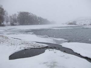
The Don River freezes in mid-November - early December. The upper part of the river is under ice for 140 days a year, but the lower part freezes for only 30-90 days.
As already mentioned, the first rise in water in the river is observed in mid-late spring, then in June-July it decreases slightly, but in August and September there is a new high water, due to the large amount of rain that falls in late summer-early autumn .
Middle Don
After Black Kalitva the steppe zone begins. Rounding the East Don ridge (a spur of the Central Russian Upland), the river turns east and forms a large bend. From the left bank the Khoper, Medveditsa and Ilovlya flow into it. The Don Valley either expands, at the confluence of tributaries, up to 6-9 km (and below the Khoper even up to 12-15 km), then, squeezed by bedrock, it narrows. Near the village of Kazanskaya, for example, its width is only 1.0-1.8 km. The waters of the Don also either spill over 400 meters or more, or rush in a rapid foamy stream between the shores that are closer to 50 meters.
As before, chalk cliffs stretch to the right of the river, rising up to 100 meters in places, but on the other side, among the bushes and grasses, bald patches of sand are beginning to appear more and more often. There is an assumption that the Medbeditsky sands arose where the Khazars had livestock grazing - topchak, and the Tsimlyansky sands - the result of the Polovtsian topchak. One way or another, the sands have always caused the Don villages a lot of trouble. The wind used to cover the gardens and orchards with sand and sweep up sandy snowdrifts level with the windows of the huts.
Below the village of Kazanskaya, compressed by sands approaching from both sides, the Don rushes from side to side, writhing along its valley like a snake. Its sandy bed is unstable, the fairway is changeable and narrow, and during low water periods one had to swim here with a marking - a special measuring rod for measuring depths. Hanging over the side, the sailor, like a blind man with a staff, literally felt the bottom with it to guide the ship in the most dangerous places. The water level over the rifts of the Middle Don often dropped to 40 cm.
“The rifts here are better than those on the Volga. Even in the morning I was amazed at the skill with which our captain crawled... along a narrow, narrow stream, squeezed on all sides by shallows,” wrote V. G. Korolenko in one of his letters.
Neither grass, nor fences, nor ditches could stop the advance of sands on Kalach-on-Don. The city was protected only by forest plantings made in the 50s of our century. And then, under the cover of forest shelterbelts, the man launched a counterattack on the sands.
Beyond Ilovlya, the Volga-Don transport began earlier. At this point, the Don is separated from the Volga by only about 100 km, and their tributaries come even closer to each other. Therefore, Ilovlya has long been connected by portage with Kamyshinka, Panshinka with Pichuga. But the most famous was the route from the Volga to the Don along the Dubovka River. In the middle of the 19th century, a horse-drawn railway was even built between the Dubovka River and the village of Kachalinskaya on the Don.
Now the Volga-Don Canal named after V.I. Lenin runs along the Volga-Don interfluve. To ensure navigation along it, the Varvarovskoye and Bereslavskoye reservoirs were created on the Don slope in the valley of the Chervlennaya River, the Karpovskoye reservoir in the valley of the Karpovka River, and the Tsimlyanskoye reservoir in the Don valley.
The water regime of the Don above the Tsimlyansk Reservoir is still characterized by high spring floods and low summer and winter low water periods. The water level in the Middle Don and its tributaries Khopra, Medveditsa and Ilovlya sometimes rises by 9-10 meters in the spring. The Don floodplain in the area between Medveditsa and Ilovlya is usually filled with a layer of water of 5-6 m, so that even the tops of the bushes are not visible.
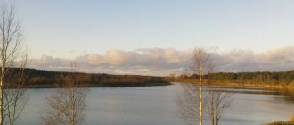
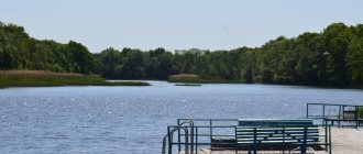
Tsimlyansk Reservoir
The Tsimlyansk reservoir stretches along the Don valley for 281 km, forming extensive bays in the lower reaches of the Chir, Aksay, Tsimli and other former Don tributaries. Its width in the southern part reaches 38 km, and its area is 2700 km2. The left bank of the reservoir is low everywhere, except for the southern part, and the right bank is steep and high. The gardens and vineyards are green all around, the fields of wheat are moving in heavy waves in the wind. The smell of ripe ears warmed by the sun mixes with the bitter smell of some steppe herbs and water. A single apple tree will accidentally flash by, and again only the Scythian mounds look thoughtfully at the irrigation canals stretching into the steppe.
The Don annually brings about 18 km3 of water to the Tsimlyansk Reservoir, and precipitation and lateral tributaries add about another 2.5 km3 of water per year. However, the annual flow through the Tsimlyansky hydroelectric complex is only about 16 km3 of water. Where does the water from the steppe sea go?
It is taken by the Don Main Canal (up to 150 m3/s in May 1975) and other irrigation systems, and is spent for the needs of navigation along the Volga-Don Canal (up to 37 m3/s in June 1972). More than a meter of water evaporates from the surface of the reservoir every year. The amount of precipitation falling per year on the Tsimlyansk Reservoir is 470 mm, and evaporation is 1010 mm. The water regime of the Tsimlyansk Reservoir is difficult. The amplitude of fluctuations in the water level in it over an 11-year period (from 1953 to 1972) was 7.85 m! Against such a background, the surge distortions of the water surface of the Don Sea, reaching 0.9 m, seem, of course, insignificant.
In summer, the water in the reservoir usually blooms so much that its surface appears to be covered with a green film. I just want to blow it away or push it aside with my hand to see clean water.
In autumn, in September - October, winds begin, often blowing for almost a week in a row. The height of the waves in the central and near-dam parts of the reservoir, where there is acceleration for the wind, reaches 2.5-3.0 m. Therefore, having received a warning about impending bad weather, motor ships head to the nearest shelter; there are eight such shelters on the Tsimlyansk Reservoir.
The reservoir begins to freeze in December, first in the northern part, and in the south, near the city of Tsimlyansk, three weeks later. The winds take a long time to break the ice there, preventing it from getting stronger. Navigation lasts an average of 232 days.
The importance of the Don for the country's economy
After World War II, the construction of various structures began on the Don, which were of great economic importance for Russia. So, to obtain hydroelectric power, a platinum was built near the city of Tsimlyansk. In 1952, a 102-kilometer-long canal was built at the latitude of the city of Volgograd, which connected the two main rivers of the European part of our country: the Don and the Volga.
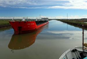
Since the Don does not have a fast flow throughout the entire length of the channel, it is a good navigable river. Ships sail along it, starting 400 km from the river’s confluence with the Sea of Azov and right up to its sources. In December and January the river freezes, so navigation on it ceases. The main cargoes transported along the Don are grain, wood and building materials. The Don and other rivers of the country are connected by many shipping canals, through which you can get from the Black Sea to the Caspian, to the Baltic and to the Arctic Ocean.
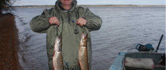
The river contains a large amount of fish (perch, pike, carp, sturgeon), so many enterprises have been built along the banks of the Don that produce fish and sturgeon caviar.
Many Russian cities were built on the banks of the Don, for example, Dankov, Zadonsk, Serafimovich, Kalach, Tsimlyansk, Rostov, between which tourist boats constantly ply.
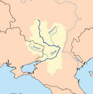
Main tributaries of the Don
As mentioned above, Father Don has more than 5,000 tributaries. Here are the main ones:
- River Beautiful Sword.
- Pine.
- Chir.
- Donets.
- Voronezh.
The rivers Krasivaya Mecha and Sosna are the right tributaries of the upper Don, into which they flow between the cities of Dankov and Zadonsk. The Voronezh River is a left tributary of the middle Don. The Chir and Donets rivers are right tributaries of the lower Don, with the Chir flowing into the Don a little below the city of Kalach, and the Donets merging with the Don near the city of Konstantinovsk.
Other smaller rivers flowing into the Don are Tsimla (186 km long) and Kumshak (121 km long).
List of tributaries
This list lists 103 tributaries of the Don, indicating the following characteristics: the size of the river, the bank along which it flows, the distance from the confluence to the mouth of the Don, the length and area of the basin.
The list may not include temporary (seasonal) watercourses, rivers whose names and main characteristics could not be clarified, as well as some particularly small streams with insignificant water flow.
Table I. List of tributaries of the Don
Marks: S - the largest (high-water) tributary; L is the longest tributary.
| № | Name | Size [1] According to their size, rivers are divided into streams, small, medium and large. The streams are less than 10 km long; small rivers - basin area less than 2000 km², medium rivers are rivers whose basin area is equal to or more than 2000 km², but less than 50,000 km²; other rivers are considered large. | Shore | km from the mouth | Length, km | Basin area, km² | |
| 1 | Bobrik | small | right | 1862 | 10 | 43.5 | |
| 2 | Ivankovsky | Creek | left | 1859 | 6 | ||
| 3 | Galleys | Creek | left | 1857 | 9 | ||
| 4 | Luthorich | small | right | 1848 | 25 | 157 | |
| 5 | Driska | Creek | left | 1843 | 7 | ||
| 6 | Rzhavets | small | right | 1841 | 11 | 35.5 | |
| 7 | Donets | small | left | 1840 | 16 | 165 | |
| 8 | Fedosovsky | Creek | left | 1833 | 7 | ||
| 9 | Big Sukromka | small | right | 1828 | 25 | 217 | |
| 10 | Muravlyanka | small | right | 1825 | 11 | 35.4 | |
| 11 | Kazanovka | small | left | 1816 | 11 | 42.7 | |
| 12 | Nepryadva | small | right | 1809 | 67 | 799 | |
| 13 | Smolka | small | right | 1799 | 11 | ||
| 14 | Wet Tabola | small | left | 1797 | 64 | 795 | |
| 15 | Kurtz | Creek | right | 1792 | 8 | ||
| 16 | Eruk | Creek | left | 1788 | 6 | ||
| 17 | Rykhotka | small | right | 1782 | 23 | 213 | |
| 18 | Panic | small | left | 1774 | 49 | 299 | |
| 19 | Dubochki | Creek | left | 1772 | 4 | ||
| 20 | Kruglyanka | small | left | 1748 | 15 | 93.4 | |
| 21 | Rozhnya | small | left | 1742 | 14 | 51.6 | |
| 22 | Kochurovka | small | left | 1739 | 32 | 214 | |
| 23 | Vyazovka | small | right | 1708 | 56 | 563 | |
| 24 | Repets | small | left | 1704 | 12 | ||
| 25 | Lopotok | Creek | left | 1699 | 5 | ||
| 26 | Scrofula | small | left | 1697 | 15 | ||
| 27 | Overpraise | small | right | 1684 | 15 | 100 | |
| 28 | Rakityanka | small | right | 1674 | 12 | ||
| 29 | Skvirnya | small | left | 1673 | 23 | 274 | |
| 30 | Lebedyak | small | left | 1665 | 26 | 196 | |
| 31 | Semibratsky Ravine | small | left | 1655 | 10 | 30.2 | |
| 32 | Beautiful Mecha | average | right | 1645 | 244 | 6000 | |
| 33 | Pavelka | small | left | 1641 | 25 | 94.7 | |
| 34 | Kuymanka | small | left | 1625 | 25 | 112 | |
| 35 | Sukhaya Lubna | small | left | 1618 | 28 | 355 | |
| 36 | Chernova | small | right | 1616 | 20 | ||
| 37 | Pine | average | right | 1608 | 296 | 17400 | |
| 38 | Springs | Creek | left | 1606 | 7 | ||
| 39 | Student | small | left | 1598 | 10 | 169 | |
| 40 | Peskovatka | Creek | left | 1589 | 8 | ||
| 41 | Sushkov Well | small | left | 1587 | 14 | ||
| 42 | Chichora | small | right | 1585 | 16 | 104 | |
| 43 | Rogozhny | Creek | left | 1581 | 5 | ||
| 44 | Khmelinka | small | right | 1573 | 17 | 76.9 | |
| 45 | Kamenka | small | right | 1557 | 29 | ||
| 46 | Repets | small | left | 1536 | 46 | 392 | |
| 47 | Rotten | small | left | 1534 | 10 | 44.7 | |
| 48 | Again | small | right | 1523 | 74 | 1770 | |
| 49 | Cradle | small | right | 1511 | 13 | 80.1 | |
| 50 | bliss | small | right | 1475 | 21 | 124 | |
| 51 | Bolshaya Vereyka | small | right | 1468 | 45 | 435 | |
| 52 | Repishche | small | left | 1461 | 18 | 134 | |
| 53 | Veduga | small | right | 1439 | 94 | 1570 | |
| 54 | Maid | small | right | 1425 | 89 | 1520 | |
| 55 | Voronezh | average | left | 1403 | 342 | 21600 | |
| 56 | Thornwood | small | left | 1340 | 79 | 1080 | |
| 57 | Maid | small | right | 1322 | 54 | 612 | |
| 58 | Potudan | average | right | 1317 | 100 | 2180 | |
| 59 | Quiet Pine | average | right | 1299 | 161 | 4350 | |
| 60 | Ikorets | average | left | 1262 | 97 | 2000 | |
| 61 | Bityug | average | left | 1197 | 379 | 8840 | |
| 62 | Middle | average | left | 1161 | 89 | 2420 | |
| 63 | Kazinka | small | left | 1125 | 24 | 160 | |
| 64 | Black Kalitva | average | right | 1105 | 162 | 5750 | |
| 65 | Mamonovka | small | left | 1057 | 35 | 688 | |
| 66 | Bogucharka | average | right | 1022 | 101 | 3240 | |
| 67 | Tulucheevka | average | left | 983 | 138 | 5050 | |
| 68 | Sukhoi Donets | small | right | 953 | 25 | 293 | |
| 69 | Matyushina | small | left | 939 | 38 | 482 | |
| 70 | Peskovatka | small | left | 926 | 80 | 1560 | |
| 71 | Quiet | small | right | 888 | 76 | 1370 | |
| 72 | Reshetovka | small | left | 876 | 21 | 154 | |
| 73 | Black | small | left | 867 | 22 | 214 | |
| 74 | Zimovnaya | small | left | 849 | 34 | 271 | |
| 75 | Yelan | small | left | 834 | 41 | 707 | |
| 76 | Khoper | big | left | 823 | 979 | 61100 | |
| 77 | Ursa | average | left | 792 | 745 | 34700 | |
| 78 | Duct | small | left | 784 | 36 | ||
| 79 | Dry Digging | small | right | 702 | 26 | 480 | |
| 80 | Tupoles | small | right | 627 | 15 | ||
| 81 | Ilovlya | average | left | 604 | 358 | 9250 | |
| 82 | Tishanka | small | left | 584 | 57 | 778 | |
| 83 | Panshinka | small | left | 571 | 56 | 929 | |
| 84 | Blue | small | right | 538 | 27 | 720 | |
| 85 | Karpovka | small | left | 494 | 36 | ||
| 86 | Don Queen | small | left | 479 | 111 | 992 | |
| 87 | Chir | average | right | 456 | 317 | 9580 | |
| 88 | Myshkova | small | left | 455 | 100 | 1400 | |
| 89 | Solon | small | right | 426 | 36 | 385 | |
| 90 | Aksenets | small | right | 422 | 51 | 633 | |
| 91 | Esaulovsky Aksai | average | left | 414 | 179 | 2588 | |
| 92 | Kurmoyarsky Aksai | small | left | 397 | 101 | 1843 | |
| 93 | Tsimla | small | right | 349 | 115 | 1510 | |
| 94 | Kumshak | small | right | 327 | 121 | 759 | |
| 95 | Salty | small | left | 324 | 2 | 148 | |
| 96 | Old Don | small | left | 270 | 38 | ||
| 97 | Seversky Donets LS | big | right | 218 | 1053 | 98900 | |
| 98 | Sal | average | left | 165 | 776 | 21300 | |
| 99 | Aksai | small | right | 134 | 79 | ||
| 100 | Manych | average | left | 99 | 420 | ||
| 101 | Cherkasy | small | left | 66 | 13 | ||
| 102 | Temernik | small | right | 44 | 33 | 293 | |
| 103 | Koisug | small | left | 32 | 55 | ||
Mouth of the Don River
Which sea does the Don River flow into? Of course, in the Azov Sea, however, the delta or mouth of the river is not the largest in area, despite the fact that the Don brings the most water to the Sea of Azov. The mouth of the Don is only 538 km2 in area, which is equal to 12.5% of the area of the delta of another important river flowing into the Sea of Azov, the Kuban.
The Don Delta, which in ancient times was known as the “Palus Meotis” (the marshy area of the Meotians - the people who inhabited these places), is located on the territory of the Rostov region in the Taganrog Bay. The Don flows into the Sea of Azov in its northeastern part. The mouth is a marshy area with many lakes, between which there are islands covered with reeds. The fauna of the Don is known for its large number of jackals and pheasants. One of the main features of the river mouth off the coast of the Sea of Azov, where the Don flows, is the large amount of silt that is deposited annually, therefore, in order to maintain navigation in the Don delta, work is constantly underway to clean the existing canals.
Nature of the Don
The Don basin is located mainly in steppe and forest-steppe zones. The southeast is partially semi-desert. This is the main factor in the species presence of the flora and fauna of the Don region. Added to this is the fact that a huge part of this territory is cultivated by humans. Wildlife is becoming less and less.
The main part of plant species is found along the floodplain sections of the river: sedge, reed, marsh cinquefoil, marsh horsetail. Buckthorn, willow, birch, alder and many other representatives of the flora grow here.
In the water bodies of the Don basin there are about 80 species of fish: pike, catfish, burbot, pike perch, grass carp, rudd, bream and many others. Birds include storks, herons, cranes, ducks, geese, and eagles.
Mammals include roe deer, wild boars, beavers, jerboas, otters, and weasels. There are reptiles and amphibians: newts, frogs, snakes, turtles.
"Quiet Don"
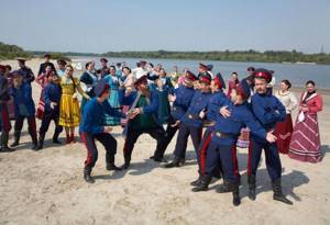
When considering the question of where the Don River flows, one cannot help but mention the Cossacks. The history of the Russian Cossacks is closely connected with the Don River, because they settled on its banks back in the 16th-17th centuries. The Don is the central theme of all the works of Mikhail Sholokhov, who was born in the Cossack village of Veshenskaya. His world-famous literary work Quiet Don (1957) tells the story of the Don Cossacks and the destruction of their way of life after the First World War and the Civil War.