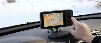
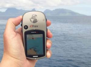
In the last decade, hardly anyone could imagine a tourist without a guitar and stew, but today such people mostly take specialized equipment on hikes. A navigator became an obligatory companion for them. This device is capable of handling a number of complex tasks and can exchange data with other mobile devices. The needs of each tourist are individual, so navigator manufacturers have to constantly improve the products they provide. Trying to make the device the most efficient and reliable, the developers introduce many useful functions into it, which is appreciated by mushroom pickers, hunters and fishermen.
Buyers of tourism accessories are distinguished by their scrupulousness. They order mostly time-tested devices that have a sufficient number of positive reviews. However, the need for a new device arises much more often than we would like. The reasons for this may be the following: the device was damaged after a fall, was lost, drowned in a swamp, or forgotten in a parking lot. The specificity of the products presented is that it is unlikely that it will be possible to purchase the same option that the tourist had before. Therefore, you have to delve into the essence of new products and understand the operating features of modern flagships. The presented rating, obtained on the basis of analytical data and user reviews, will make the purchasing process much more conscious.
Table: top 6 navigators for the forest
| Model | Best Features | Permission | Working hours | Screen diagonal | Price from (RUB): | |
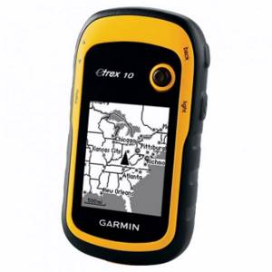
| Garmin eTrex 10 | according to reviews | 128×240 | 25 h | black and white 2.2 " | 7 100 | Find out prices |
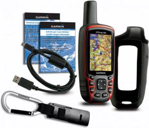
| Garmin GPSMAP 62 | simple, cheap | 160×240 | 20 h | color 2.6 " | 5 700 | Find out prices |
| Garmin GPSMAP 64st | for hunting | 160×240 | 16 h | color 2.6 " | 22 500 | Find out prices |
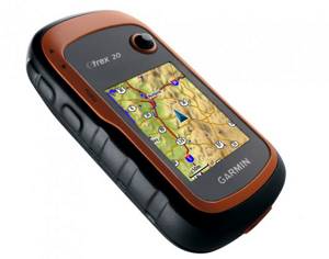
| Garmin eTrex 20x | for hiking in the forest | 240×320 | 25 h | color 2.2 " | 11 400 | Find out prices |
| Garmin Dakota 10 | for mushroom pickers | 160×240 | 20 h | color 2.6 " | 10 900 | Find out prices |
| Garmin eTrex Touch 25 | portable | 160×240 | 16 h | color 2.6 " | 13 400 | Find out prices |
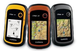
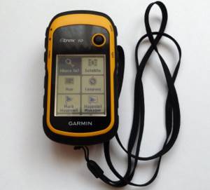
Garmin eTrex 10 - the best GPS navigator for orienteering in the forest, according to reviews
Garmin eTrex 10 is considered an entry-level portable navigator. The recently updated model includes the use of electronic geocaching. The operation of the device is based on GPS + GLONASS technology. The introduction of GLONASS technology, distributed in the Russian Federation, made it possible to reduce the signal reception time required to determine the location by 20%.
The updated version has improved the user interface and added a base map of the world. A useful change from the manufacturer was the use of a USB interface instead of a standard COM port. Garmin eTrex 10 is equipped with an improved 2.2 diagonal monochrome display, making it easy to use in different lighting conditions. The durable housing made of waterproof material ensures functionality in all weather conditions. The firmware interface is simplified, which will allow the user to quickly understand the specifics of the device’s operation.
Pros *
- robust design;
- the model is available on the market;
- long battery life.
Minuses *
- black and white display;
- inability to download an additional map;
- limited memory.
Manufacturers and prices
Navigators from the American company Garmin are very popular in the world, which uses the latest achievements of science and technology to create high-precision navigation devices.
The body of Garmin navigators is protected from shock and water penetration, which makes it possible to use it freely and increases the service life of the device
Garmin
Garmin produces automobile, tourist, aviation and marine GPS navigators, but the most popular are devices for tourism, hunting and fishing.
They have the following significant advantages:
- The small size and light weight of the device make it easy to use and carry;
- There is a display with three levels of backlighting , on which image clarity is maintained even in bright sunshine;
- A simple menu is acceptable to most consumers
- The case is protected from shock and water penetration , which makes it possible to use it freely and increases the service life of the device;
- The memory contains topographic maps , the number of which can be supplemented independently as needed;
- There is a built-in barometer , which is used to determine the phases of the moon and the presence of fish in the reservoir;
- There is a function for determining the height of the terrain above sea level;
- Data about the route taken is automatically saved ;
- The device runs on batteries and rechargeable batteries ; if you use it for a long time without an additional power source, you just need to replace the batteries.
The disadvantage is the high cost of the navigator, which fully corresponds to the quality and performance of the product.
Garmin E-Trex 10
Garmin E-Trex 10 can be called the most inexpensive option, its cost is 5-6 thousand rubles, it has a shockproof and waterproof yellow-black body, black-white display measuring 36 by 43 mm. It has the ability to store information about 50 routes and 1000 travel points. Battery life is more than 24 hours, simple and convenient menu.
Its advantages and disadvantages are:
- A reliable assistant on hiking trips;
- Indispensable in the open waters while fishing;
- In lowlands there may be communication problems;
- Small amount of memory.
Garmin E-Trex 20
Garmin E-Trex 20 is more expensive, its cost is 10 thousand rubles and more.
Its technical characteristics:
- Two navigation systems are used - GPS and Glonass;
- Durable housing;
- High resolution color display;
- Built-in memory 1.7 GB;
- Duration of autonomous operation 25 hours;
- It is possible to save data about 2000 routes and 2000 route points.
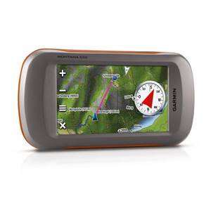
Garmin Montana 650T
Garmin Montana 650T costs 20 thousand rubles and more; it belongs to the high price category, has a beautiful appearance and a wide range of operational functions. A large, high-resolution screen provides clear images, high signal sensitivity and device speed. The disadvantage is the large weight, which causes inconvenience during transportation.
Specifications:
- The display has a diagonal of 4 inches, color and touch;
- Built-in three-axis electronic compass;
- It is supposed to use an additional memory card;
- The device runs for 16 hours on a lithium-ion battery, as well as on three regular AA batteries;
- Built-in five megapixel camera with time, date and coordinates;
- The screen can be in a vertical or horizontal position.
Garmin navigators will help travelers accurately determine the coordinates of their location, and anglers will remember fishing spots and return to them during their next fishing trip.
Garmin GPSMAP 62 - a simple and cheap navigator for forests and fishing
The presented device will be a godsend for people with an active lifestyle. Thanks to its compact size, the device fits in a bag or pocket. This option is suitable for a runner, cyclist or the average hiker. The GPSMAP 62 model features built-in fisherman and hunter calendars. In addition to topographical diagrams, the navigator's arsenal includes devices for professionals: a 3-axis compass, a barometric altimeter, a 5-megapixel camera, and autofocus.
The durable housing allows you to dive under water to a depth of one meter. However, the owner should not experiment for more than 30 minutes. A significant part of the surface of the body is made of rubberized material, and therefore the device will not slip out of wet hands. The included lanyard is long enough to hang the device around your neck or to organize a simple belay on a backpack strap.
Pros *
- Carbin for fastening included;
- availability of a spare battery;
- The body is well assembled.
Minuses *
- braking during operation;
- touchscreen instead of a sensor.
Garmin GPS 60
The best tourist navigator for fisherman, Magellan type. The device is popular and, thanks to its work, has earned a positive reputation. It has several additions that simplify the user's work and allow the navigator to be used in various situations. In order to choose the right model, you should know the technical characteristics.
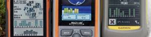
The monochrome display provides the user with high quality images. There is a 4-level indication that determines the quality of the gray color. Also, these models have LED backlighting of the screen, which allows you to easily use the navigator at night.
There are several connectors on the case through which you can provide communication with a computer or connect an antenna, which will make signal reception faster and higher quality.
There is a WAAS function that allows you to determine the user’s location with great accuracy, up to several meters.
Initially, maps of the main cities of the world are loaded into the device. The GPS function allows you to quickly and accurately plot a route to any of them.
The autonomy of the device is at a high level. 2 AA batteries can power the device for up to 28 hours. This creates not only ease of use, but also significant savings on the purchase of consumables.
When choosing a navigator, you should choose this model. Garmin GPS 60 becomes an excellent assistant for both fisherman and hunters. A large number of useful functions and additional information will make using the device truly enjoyable. The pricing policy of the navigator starts from 14,500 rubles.
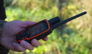
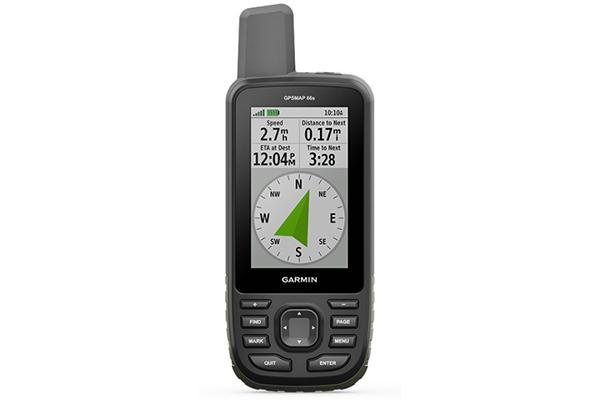
Garmin GPSMAP 64st - the best GPS navigator for hunting
Garmin's rugged, portable tool features Bluetooth or ANT wireless connectivity. The device is equipped with a color screen with a diagonal size of 2.6, which allows you to obtain acceptable picture quality even during intense lighting. Highly sensitive GPS and GLONASS modules include the use of a quad helix antenna. The firmware includes downloaded maps of Russian roads, as well as an annual subscription to BirdsEye satellite images. Like the review leader, the device has a 3-axis compass with a barometric altimeter built into it. The maps available in the firmware include national, state or local parks. Also, the owner of the unit can get acquainted with information about the height of the terrain, the location of trails, rivers, lakes and other objects. Thanks to the Smart Notification function, you can receive text messages and other alerts that will be sent to your phone. To do this, you don’t have to take your communicator out of your pocket or backpack.
Pros *
- wireless data exchange;
- specially adapted firmware for mushroom pickers and tourists;
- presence of a color display.
Minuses *
- Subscription to free patterns is valid only for 12 months.
Navigator selection criteria
Receiver capabilities
- Signals to the device come from many satellites in orbit. How many of them can a particular navigator “work” with?
- Sensitivity. Not all devices that support stable communications in open areas function reliably in the forest. This is one of the reasons why navigators installed in cars, fishing or hunting are usually useless.
Choosing survival knives - review and video of the best options
Display options
- Resolution. The clarity of the image directly depends on this.
- Navigator screen size. There is nothing to comment here.
When deciding on a display, you need to take into account the peculiarities of your vision and prepare for the worst situation (the golden rule, which many people forget). For example, you don’t have glasses at hand, the sun is on the horizon or has already gone. Will it be possible to see anything on the navigator screen? And not just vague outlines of contours, but to see a completely clear picture, a diagram.
But whether the display is color or black and white is up to the user to decide. For navigation while fishing or hunting, this does not matter. A color screen is only needed if the navigator has special options for viewing, for example, downloaded files to pass the time. How relevant is this for a person who goes out into nature for a very specific purpose?
It is unlikely that anyone would exchange an evening around the fire for a film that can be seen at home on the TV screen. And considering that the cost of a “color” navigator is significantly higher, such a device is unlikely to be needed for hunting or fishing.
Duration of continuous operation
This indicates how often the batteries will have to be replaced. This determines how much battery you need to take with you.
Availability of memory card
Navigators without this service, which determine only the geographic coordinates of the standing point, will not let you get lost. But only on the condition that the person has a compass, a map of the area and is trained to work with them. For example, it is correct to “reference”, determine the sides of the horizon, and so on. Therefore, when choosing a model, you should pay attention not only to the ability to load information into the navigator (memory capacity), but also to the presence of a built-in magnetic pointer.
All of the above are nothing more than general recommendations. Manufacturers are constantly updating, introducing, and improving something, so it is unrealistic to cover all the nuances of the functioning of navigators. For example, is it possible to mount a separate device on a dog’s collar (for hunters).
Choosing a good snowboard in 2021 - recommendations for beginners
Anglers may prefer a stationary model that is installed on a boat or boat. Some navigators have an echo sounder function. For someone who goes to nature not just to sit with a fishing rod, but to return with a rich catch, this is an indispensable help. But a hunter does not need this option at all. But if there is a built-in barometer, it will be equally useful for everyone who is forced to rely on weather conditions. The same applies to multi-level screen backlighting.
And yet – which specific navigator should a hunter or fisherman choose for himself?
Not all the advantages of devices that manufacturers and sellers emphasize to buyers are tested in practice. Some functions actually turn out to be useless, others do not live up to expectations.
- Before going to the store, it makes sense to interview friends who already use navigators. Their opinion and reviews of models are more objective.
- You can learn a lot of useful things by “visiting” thematic forums. On them, fishermen and hunters openly talk about the problems that they face when using GPS devices in “field” conditions.
The author did just that. It turned out that the most popular among “average” hunting and fishing enthusiasts are navigators under the GARMIN brand. Firstly, the devices are available in various modifications, therefore, you can choose the most suitable series. Secondly, the functionality is simple, so understanding the peculiarities of the navigator’s operation is not difficult even for a person who is still familiar with modern electronics. Thirdly, the price of the products is quite affordable, and their purchase is not burdensome for the family budget.
"E-Trex" 10 series
The device is sold in a yellow-black case that meets all requirements for moisture protection and shock resistance. Screen size 43 x 36 black and white; simple menu; continuous work throughout the day. The memory allows you to store information about 1000 standing points on 50 different routes.
How to make comfortable snowshoes for hunting from plastic pipes with your own hands
Price – within 5,500 rubles.
The same 20-series device is capable of working not only in the GPS system, but also in the domestic Glonass system. 1.7 GB memory, color screen, 2000 saved routes and marked points. All this increases the cost of the device.
Price – about 9,800 rubles.
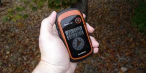
Garmin eTrex 20x - the best navigator for hiking in the woods
Externally, the device is pleasant to look at - it fits perfectly in the hand. The front panel is equipped with a joystick. There is a rubber seal around the perimeter of the battery compartment. The case is rubberized and waterproof. Batteries and rechargeable batteries can be used as a power source in the navigator. The navigator accepts vector or raster maps. The user can create routes and record tracks. The micro sd memory slot is located at the bottom of the battery compartment. A nice addition is mechanical protection against overturning. Menu elements are flexibly customizable.
Pros *
- flexible interface settings;
- uploading satellite images.
Minuses *
- the model has a sensitive joystick;
- short operating time from an autonomous power source.
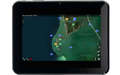
And our top 5 for Android:
![]()
BoatBeacon
BoatBeacon
$9.99, Android smartphone and tablet/iPhone/iPad, pocketmariner.com/boatbeacon BoatBeacon is a handy app for navigating high-traffic offshore anchorages. As long as the user has an Internet connection (usually no more than 15 miles from the coast), they can track boats on AIS, as well as non-AIS boats that use BoatBeacon. With BoatBeacon, sailors can view photos and details of other ships, such as speed, direction and size. The application also constantly updates positions and AIS, even while it is running in the background. Not bad for saving batteries. Lastly, the app has social media access, allowing users to share data with friends and family via email, Facebook or Twitter.
Fugawi PathAway GPS Express Edition
Fugawi PathAway GPS Express Edition
$29.95, Android - smartphone and tablet, pathaway.com/PWAndroid.htm Like many other yachting navigation apps, Fugawi PathAway GPS Express Edition has tracks, waypoints (with photos and descriptions) and routes. The great thing about the Fugawi PathAway Express app is that it allows users to create customizable and multi-layered maps. One of the new features of the application is the weather forecast display, which can be layered on other maps and displays wind, precipitation, temperature. This feature, however, is available at an additional cost. With PathAway, users can import maps from virtually anywhere, whether from the Internet, such as Google Maps, or download maps from any other navigation application. There are several versions of the application. With PathAway GPS Professional Edition ($49.95), users can track other boats and display multiple tracks and routes simultaneously. The free version includes basic tracking features, but its maps are not full-screen due to ads. PathAway GPS Lite ($4.95) offers the same features as the free version, but is full screen and does not include ads.
Marine Navigator
Marine Navigator
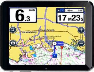
$8.48, Android smartphone and tablet, purchase on Google Play Marine Navigator advanced version of the free application, Marine Navigator Lite. Marine Navigator allows you to download NOAA raster charts for free. It displays the boat's position, SOG and COG, allows the user to add to tracks, waypoints and routes that he records, and can run in the background. Waypoints and routes can be imported and exported from GPX, and tracks are also exported from GPX. Maps update automatically based on the boat's location. Marine Navigator displays a compass and includes features for MOB situations.
MX Mariner
MX Mariner
$6.99, Android smartphone and tablet, mxmariner.com MX Mariner allows free installation of raster charts from NOAA, as well as LINZ in New Zealand, UKHO in the UK and Ireland, and NAVY in Brazil. In offline mode, maps are static. The application displays not only the current position of the yacht, but also SOG and COG. MX Mariner allows yachting users to set waypoints, tracks and routes by importing them as GPX files. As a bonus, the app has several light settings for different conditions.
Navionics Free
Navionics Free
Navionics Marine & Lakes has long been one of the best navigation apps available for Android and IOS devices. It includes excellent Navionics Gold vector charts. This application was described above in the list of applications for Apple devices.
Garmin Dakota 10 - the best navigator for mushroom pickers
A low-cost portable device, the Garmin Dakota 10 is similar to the Oregon series. The main emphasis that the manufacturer puts is accessibility for the budget segment. The GPS receiver is equipped with a touch display, which makes operating the device easy and convenient. Despite the presence of touchscreen recording, it is almost impossible to damage the module. The device perfectly picks up the satellite signal in a wide variety of urban and forest landscape conditions. Despite its budget price, the Dakota 10 includes support for 3D topographic maps. However, only 850 MB of memory is available for this. Includes USB cable and wrist strap.
Pros *
- excellent signal reception;
- stylish design;
- support for 3D topographic maps.
Minuses *
- non-expandable memory size;
- inability to exchange data with similar devices;
- There is no magnetic compass or barometric altimeter.
The best functional navigators for the forest
The line of premium models includes devices with advanced capabilities, reinforced design, and modern technological features. They maintain autonomy much longer, show increased resistance to dirt, moisture and shock, withstanding extreme travel. Experts considered 2 offers for hunters, fishermen, mushroom pickers and tourists from the major brand Garmin to be the most worthy.
Garmin GPSMAP 66st
Premium model equipped with the latest software version. The main advantage is the built-in memory of up to 16 GB, which is more than enough to download various maps of the area. The tourist navigator for the forest supports several navigation systems and supports access to satellite images from the BirdsEye service. It features a large 3-inch screen with a resolution of 240×400 pixels and a body shape reminiscent of a walkie-talkie or mobile phone. On the display you can not only view maps, but also photographs. For active recreation, the list of functions includes a barometer and a compass with high data accuracy. And to manage the settings, there is the Active Weather function, support for the official website and a special Garmin Explorer application. For autonomy, two AA batteries are installed that can withstand up to 16 hours of continuous operation.
Advantages
- Large screen;
- Internet access;
- Built-in memory;
- Ease of management;
- Many useful options;
- Connecting additional sensors;
- Economical battery consumption.
Flaws
- Price;
- Dimensions.
This is an excellent offer for long walks in any, even unknown, areas. Users like the ease of downloading satellite images, which allows them to plan their route and parking spots in advance. For a large amount of memory and advanced functionality, you will have to pay an above-average price, and autonomy results from the large size of the device.
Garmin GPSMAP 276Cx
A universal push-button model equipped with a large 5-inch screen and a picture resolution of 800x480. It can be used for travel and can also be installed in all types of transport. The manufacturer installed the necessary cards in absentia, and also provided the owner with 8 GB of memory for subsequent downloads of new images. There is also a slot for an additional SD memory card. For comfortable control, interfaces are provided - Wi-Fi for accessing the Internet, USB for charging and connecting to a PC, as well as Bluetooth for synchronizing with a smartphone. The case is reliably protected from moisture and dust according to the IPx7 standard, which means it is a reliable navigator for forests and fishing. For autonomy, both a rechargeable battery and AA batteries are provided. In the first case, work lasts up to 16 hours, in the second – up to 8 hours. Inside the case there is an antenna for communication and reception of GPS and GLONASS satellite signals. Withstands temperatures from -15 to +50 degrees. Additional options include a barometric altimeter, compass, and calendar.
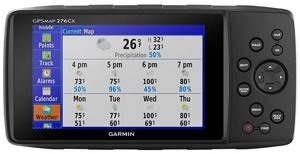
Advantages
- Large clear screen;
- Russian-language menu;
- Wide possibilities;
- Antenna slot
- Synchronization with smartphone, PC;
- Track-Back path calculation;
- Battery, batteries.
Flaws
- Price;
- The screen is not touchscreen.
This is an excellent offer for Russian roads with maps of forest sites. It easily interfaces with a personal computer or smartphone (iOS and Android), and connects to the Internet.
Users approve of the suction cup for attaching to vehicles, good battery life, and large, clear screen. They also confirm the high accuracy of satellite signal reception. The downside is the price and push-button control.
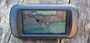
Garmin eTrex Touch 25 - portable pocket navigator for the forest
The eTrex Touch 25 is a compact, rugged and reliable portable navigator with GPS/GLONASS receiver. The unit has a color touch screen, as well as a 3-axis electronic compass with tilt compensation. Using several compatible mounts allows you to easily fix the device on an ATV, bicycle or car. The eTrex Touch 25 navigator is equipped with a slot for a microSD memory element and 4 GB of internal memory.
Pros *
- color capacitive touch screen with a diagonal of 2.6;
- using an external memory source.
Minuses *
- Some features are supported only by subscription.
Middle segment (from 20,000 to 40,000 rubles)
Garmin eTrex Touch 35
pros
- compactness
- quick satellite search
Minuses
- weak processor
From 32,600 ₽
ON GOODS FOR PURCHASES YANDEX.MARKET
Garmin eTrex Touch 35 with a color touchscreen supports GPS and GLONASS satellite navigation systems. Pre-installed TOPO maps include detailed road maps of Russia. The 3-axis tilt-compensated compass provides the most accurate data when the user is standing still. Display diagonal – 2.6 inches.
Garmin GPSMAP 66st
pros
- capacious battery
- big screen
- clear controls
Minuses
- expensive battery
From 34,200 ₽
ON GOODS FOR PURCHASES YANDEX.MARKET
The Garmin 66st premium GPS navigator supports multiple global satellite systems to track your location in the most challenging environments. Support is provided by a three-axis compass and barometric altimeter. For convenient work with tracks and routes, compatibility with the Garmin Explore website and mobile application is provided.
Garmin GPSMAP 64
pros
- the screen does not glare in the sun
- sufficient brightness reserve
Minuses
- difficult installation of additional cards
From 20,900 ₽
ON GOODS FOR PURCHASES YANDEX.MARKET
The Garmin GPSMAP 64 navigator with pre-installed maps of Russian water bodies is an excellent choice for a tourist or mushroom picker. Equipped with a 2.6 inch color screen. Excellent images are guaranteed even in strong sunlight. Highly sensitive GPS and GLONASS receiver with quad helix antenna provides a clear signal in hard-to-reach areas.
How to choose the right navigator for the forest
A well-chosen navigator is an assistant with whom you will never get lost anywhere. At the same time, it doesn’t matter where the person was thrown by chance: on a walk, a hiking trip, a car trip, fishing, hunting, mushroom picking. So that at the most crucial moment in the middle of an unfamiliar area it does not become clear that the ordered device is completely ineffective and cannot build a route, you should choose it carefully.
There is an opinion that a car option will be enough for a hike in nature. However, this is far from the case: the mentioned units are designed exclusively for navigation on city streets in driving mode. In turn, a portable device for tourists is designed in such a way that it can be used with an independent power source for a long period (2-3 days). Also, such devices must be functional when visibility of the satellite is limited, which is due to the sensitivity of the antenna.
Terrain orientation: maps and routes
Common technologies for determining a person's location are GLONASS and GPS. The presented modules facilitate automatic route construction. Most devices on the market are hybrid: they use both modules, which speeds up signal transmission and reception. Important for positioning will be the ability to download maps in high resolution, which, in turn, places certain requirements on the hardware of the device.
Display
An effective device will be with a display with the maximum possible number of dots. This will allow you to be confident in the quality of the picture and the accuracy of determining the location. When you need a device that is economical in terms of energy consumption, it is better to take a closer look at the black and white options, otherwise, order a navigator with a color display.
Memory and processor
The number of maps that can be loaded depends on the size of the memory, as well as the possibility of expanding it using external sources. Equally important is the scaling function, which depends on the speed of the hardware.
Case and battery
The best option for a device would be a navigator equipped with a large battery capacity. The ability to use batteries instead of batteries is convenient during long treks.
When choosing a case, pay attention to the following: compactness, weight, shock resistance and moisture resistance. These parameters are important for lovers of extreme walking. Most prefer compact devices that fit confidently in the palm of your hand or fit into your pocket.
Additional functions and modes of the device
The navigator is a complex electronic device that is equipped with a processor of a certain power, a small screen and an operating system. By and large, it resembles a small tablet or communicator that can be used for more than just navigation. Its additional features include the following:
- obtaining information about fishing objects, lunar phases;
- autosave last route;
- entering into the device’s memory catching points on the reservoir;
- determination of altitude above sea level;
- Using the built-in barometer to forecast the weather.
The best universal navigators for hunters
A universal navigator is a convenient and easy-to-use device that will come to the rescue both in the forest and within the city. It can be used for hunting, fishing, hiking, or for comfortable movement along city streets by car.
A good forest navigator must be reliable, so you should not save money by purchasing devices from unknown manufacturers. It is also recommended to pay attention to the warranty period of service, because an inexpensive device can fail at the most crucial moment. The rating of the best navigators will help you choose the optimal device that will definitely not let you down in an emergency.
Garmin eTrex 10
The device does not have the ability to increase memory capacity.
Garmin navigators for hunting are the best choice for everyone. The manufacturer offers reliable devices in any price range. Thus, the eTrex 10 model will cost only 7,800 rubles. This is the cheapest navigator for the forest with the most advanced functionality and high-quality assembly. For this price the buyer will receive:
- waterproof housing;
- large display;
- combined type of nutrition;
- compact sizes.
The display in this device is monochrome, 2.2” diagonal. Control is provided by a movable joystick located in the upper right corner of the device. This is the simplest navigator for forests and fishing, so it has no additional functions.
Disadvantages of the device:
- the joystick can get caught on clothing, which leads to a route failure;
- there is no possibility to load additional maps;
- small amount of memory without expandability;
- monochrome display.
With all these shortcomings, the monochrome display consumes very little energy, so the navigator demonstrates a long battery life.
Lowrance iFinder H20
This navigator belongs to the mid-price range, but at a price of 9.5 thousand rubles, it has a powerful processor and easy to use.
Advantage:
- battery powered;
- high degree of moisture protection of the case;
- nice design;
- high-quality control buttons;
- bright and clear display;
- ability to transfer data to a memory card.
One set of the simplest batteries will provide 10-12 hours of uninterrupted operation. The disadvantages include the lack of additional functions and the rather inconvenient shape of the case, which makes the navigator difficult to carry in your pocket.
Garmin Oregon 650
The Garmin Oregon 650 navigator does not have enough impact strength.
Garmin navigators for hunting and fishing are highly reliable, but also overpriced. This representative costs about 30 thousand rubles. Its advantages:
- built-in camera;
- 3.5 GB of internal memory;
- battery powered;
- bright 3" display;
- powerful processor.
Thanks to a powerful processor, the device shows high operating speed. The navigator has many additional functions: barometer, calendar, compass, tide calendar, etc. It is equipped with a good 8 megapixel camera and is capable of storing up to 200 routes in memory.
The main drawback is the unreliable case. Despite the moisture protection, the case is loose, easily scratched and requires careful handling.
Advice! Taking into account the high cost of the device itself, it is recommended to immediately purchase a high-quality shock-resistant case, otherwise the navigator may not survive a fall.
Garmin GPSMAP 64s
Another good and relatively inexpensive navigator for the forest is Garmin GPSMAP 64s. It will cost approximately 18 thousand rubles. Device Features:
- light weight;
- convenient buttons;
- built-in camera and compass;
- screen 2.6”;
- barometer.
The device has 4 GB of internal memory, supports memory cards and can connect to a smartphone. Despite its light weight, the navigator is distinguished by its large dimensions and a protruding antenna, which, although it improves the quality of communication, noticeably interferes with carrying the device in your pocket.
Garmin Foretrex 701
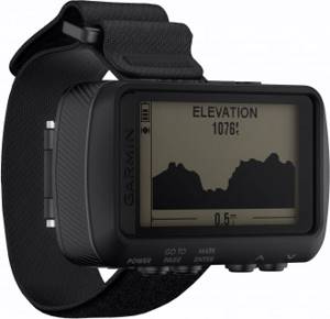
The GPS navigator has a fairly high price
. An interesting, but expensive model of a wrist watch navigator from a well-known brand. Such a device will cost 38 thousand rubles. Its advantages:
- comfortable shape;
- display 2";
- battery powered;
- memory for 20 routes;
- compass, barometer, calendar;
- powerful processor and receiver;
- waterproof case.
Despite the high cost, this navigator is not perfect. The main disadvantages are the lack of support for memory cards and the small number of routes that can be stored in the built-in memory.