Which company's forest navigator is better to choose?
Dozens of companies from all over the world produce useful gadgets and devices for mushroom pickers, hunters, fishermen, and amateur tourists. But not everyone can boast of absolute compliance with all requirements for quality, functionality, and reliability. In 2021, the best navigators for forests were offered by the following manufacturers:
- Garmin is an American company, a progressive manufacturer of GPS navigation equipment and smart watches. Founded in 1989. In addition to offices in different states of America, there is a representative office in Europe. The devices are actively used in various spheres of human life. For many years, the brand has been a leader, offering a range of models at different prices.
- Kinsmirat is a Chinese company that was founded in 1992. It is considered a leader in the production of metal products using the Die Cast method (i.e., injection molding). The production cycle begins with the development of drawings and ends with dealer sales.
- Yasmart is a technology brand from Russia that develops, produces, and sells smart gadgets and devices for human comfort. More than 25 years of experience helped us achieve success. Smart products are intended for home, vehicles, travel, and various personal devices. The product range includes mainly air purifiers and humidifiers, household appliances, electronics, and GPS.
Features of using navigators
Models of manufactured navigators have a number of features that must be taken into account during operation:
- limited autonomy of the device, which is usually limited to 12 hours (without replacing the power source);
- the use of color displays and additional devices in navigators contributes to increased consumption of battery capacity;
- not all models have sufficient protection from moisture;
- universal navigators are the most convenient to use;
- it is necessary to take into account the price range and functionality of the devices;
- Additional devices play a big role in the use of navigators: built-in antennas, special connecting wires designed to recharge batteries.
Using devices to determine location allows you to better plan your vacation, significantly reducing wasted time.
Rating of navigators for the forest
There are many models on sale today for different purposes and tasks. What to choose depends on your personal needs and budget. While one person wants to buy a forest navigator cheaply, another is looking for a multifunctional device from a premium line. Experts in compiling the rating relied on several criteria:
- Supported navigation systems – GPS, GLONASS;
- Housing protection class – resistance to moisture, dust, shock;
- Stability and duration of operation – power supply;
- Display characteristics – size, compactness, picture quality;
- Option to download maps from outside – support connection to PC, Internet;
- Functionality – basic, advanced;
- Memory and processor – memory size, expandability, performance;
- Autonomy – duration of operation without recharging;
- Comfort – size, weight, ergonomics.
Demand indicators and the percentage of positive customer reviews helped us select from several dozen similar devices. Based on this information, it was possible to determine all the strengths and weaknesses of the nominees. The top five products have a price that fully corresponds to their quality and functionality.
The best car GPS navigators
Selecting a device display
- Display resolution - the higher it is, the higher the clarity of the image.
- The size of the screen itself . No comments needed.
When choosing a display, you should choose it solely for your eyesight and prepare for the worst. For example, the sun has already gone or is about to set. What then can be seen on the screen? In addition, you need to see not some outlines, but a clear diagram.
Color screen
The presence of a color screen will not affect the main function of the device, orientation on the terrain. A color display can come into play in a situation where the user needs to view files downloaded to it. But why do this need to be done in nature if your goal is far from looking at pictures?
We also recommend reading:
How to properly tie a jig to a fishing line Diagram on how to learn how to tie a hook to a fishing line Tourist knots - types and methods of tying Gardner's loop for a feeder: how to tie
In addition, the presence of a color screen significantly increases the cost of a GPS navigator, so why pay more? Why watch a movie outdoors when you can watch it at home on TV or on your computer? Yes, and pay extra at the same time.
Autonomy
Since civilization has not yet reached the depths of nature, electricity and other power sources are absent there. Therefore, you need to plan in advance how many batteries to take with you.
The best simple navigators for the forest
The greatest demand is for simple and cheap forest navigators from the budget segment. They are suitable for short walks in nature; with a basic set of options they cope well with them. Most often they are bought by fishermen, mushroom pickers and hunters. As a rule, the price range does not exceed 15,000 – 20,000 rubles. And in this rating category, experts presented 3 models for those who do not want to overpay for unnecessary, outdated features.
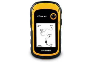
Garmin eTrex 10
The review opens with a reliable model from a well-known manufacturer in its market segment. It differs from similar products by the highest indicator of demand and positive reviews. Allows you to navigate the area in case of mushroom picking, hunting or fishing. Two supported navigation systems are responsible for receiving satellite signals – GPS and GLONASS. The quality is several times higher than that of many similar models. Two AA batteries are responsible for autonomy. The monochrome screen allows you to withstand up to 2 days of operation without recharging. In addition to the map, there is a compass with a function for determining speed and azimuth for making calculations. The case demonstrates high resistance to any mechanical stress, moisture, and temperatures down to -18 degrees. The universal mount allows you to install Garmin eTrex 10 on a bicycle, motorcycle, snowmobile and other type of transport. A 2.2-inch LCD monochrome screen is provided for visualization. The built-in Track-Back function saves the movement track to plot the return route.
Advantages
- Performance;
- Satellite signal receiver sensitivity;
- Good autonomy;
- Ease of Management;
- Availability of useful functions;
- Resistance to temperatures, external influences;
- Inexpensive.
Flaws
- The button is not blocked from arbitrary pressing;
- Small screen size.
In reviews, buyers write that the model also supports the WASS system, which corrects GPS data. The advantages include speed, good signal reception, availability of useful features, compactness, autonomy due to the black and white screen. Some consider the display size to be insufficient and also complain about spontaneous button presses due to the lack of a lock.
Kinsmirat WL0023
With the help of such a device, the owner will always be able to get to the desired destination, think through the route in advance and even calculate the distance. And to return back, the entire road traveled can be recorded while maintaining the speed, current position, and exact time of synchronization with the satellite. In shape and compactness, the Kinsmirat WL0023 resembles a regular watch, equipped with a 3.5-inch backlit digital display. The body is made of matte, non-marking plastic, ensuring light weight. Good impact resistance is noted. As the owner moves, he can determine the speed. A lithium-ion battery is responsible for autonomy. With useful options, the gadget is quite easy to use. The manufacturer recommends it for tourism, camping, and drifting. The kit includes a keychain for easy carrying, a USB cable for charging, and an instruction manual.
Advantages
- Basic set of features;
- Compact, light weight;
- Convenient shape;
- Keychain for fastening;
- Impact resistance;
- Good autonomy;
- Cheapness.
Flaws
- Difficulties with purchasing;
- Fragile plastic.
In design and functionality, this is an advanced model with a basic set of functions. It is preferred by those who do not need additional commands other than determining the route for hikes and walks in nature.
Great demand is due to its low cost and original compact shape. Some buyers consider this navigator for hiking in the forest to be fragile due to unreliable plastic, and it is also not so easy to find on sale.
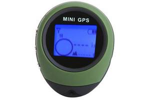
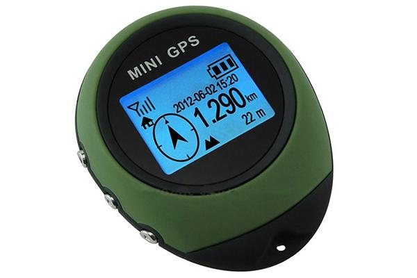
Yasmart NG1 (mini-gps PG03)
A portable model of GPS navigator for the forest in the form of a compact keychain. You can carry it in your pocket and attach it to any object with a special clip. Up to 16 waypoints are provided for plotting a route over long distances. And thanks to the built-in Track-Back option, the owner can record the entire trajectory of his movements, so that later he can return along the same path. For ease of control, an LED LCD monochrome display with a resolution of 128×64 pixels and backlight is provided, so the device can be safely used at night. A lithium-ion battery is responsible for autonomy; it will last for about 10 hours of continuous operation. A USB port and cord are included for charging.
Advantages
- Compact body;
- Convenient shape in the form of a keychain;
- Accurate determination of coordinates;
- Track-Back function;
- Autonomy, convenient charging;
- Backlight for the dark.
Flaws
- Fast battery consumption;
- Small screen size.
Reviews recommend this product due to the presence of important functions and accurate operation of the satellite communication system. It will be useful for lovers of outdoor activities and travel to various unexplored places. Minor disadvantages include the small screen size and low battery life.
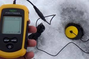
The best fish finders for fishing
Spyglass app
Using Spyglass is very simple: launch the application, wait for communication with satellites, click first on the screen, and then on the icon with a flag. Next, select the line “add current position” from the pop-up list, call it something and save it. That’s it, you can turn off the program and, putting the phone in the far pocket, go wherever your eyes take you.
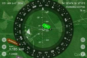
A huge advantage of this application is that it does not consume battery power when recording a track. Spyglass can be launched at any time and will find out in what direction and at what distance the save point is located. The downside of this application, like GPS Tracker, is the limited number of recorded GPS positions.
The best functional navigators for the forest
The line of premium models includes devices with advanced capabilities, reinforced design, and modern technological features. They maintain autonomy much longer, show increased resistance to dirt, moisture and shock, withstanding extreme travel. Experts considered 2 offers for hunters, fishermen, mushroom pickers and tourists from the major brand Garmin to be the most worthy.
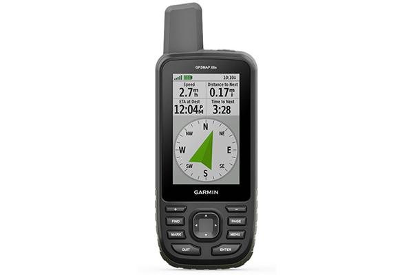
Garmin GPSMAP 66st
Premium model equipped with the latest software version. The main advantage is the built-in memory of up to 16 GB, which is more than enough to download various maps of the area. The tourist navigator for the forest supports several navigation systems and supports access to satellite images from the BirdsEye service. It features a large 3-inch screen with a resolution of 240×400 pixels and a body shape reminiscent of a walkie-talkie or mobile phone. On the display you can not only view maps, but also photographs. For active recreation, the list of functions includes a barometer and a compass with high data accuracy. And to manage the settings, there is the Active Weather function, support for the official website and a special Garmin Explorer application. For autonomy, two AA batteries are installed that can withstand up to 16 hours of continuous operation.
Advantages
- Large screen;
- Internet access;
- Built-in memory;
- Ease of management;
- Many useful options;
- Connecting additional sensors;
- Economical battery consumption.
Flaws
- Price;
- Dimensions.
This is an excellent offer for long walks in any, even unknown, areas. Users like the ease of downloading satellite images, which allows them to plan their route and parking spots in advance. For a large amount of memory and advanced functionality, you will have to pay an above-average price, and autonomy results from the large size of the device.
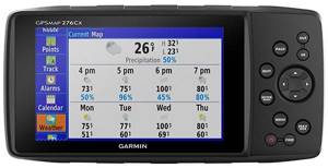
Garmin GPSMAP 276Cx
A universal push-button model equipped with a large 5-inch screen and a picture resolution of 800x480. It can be used for travel and can also be installed in all types of transport. The manufacturer installed the necessary cards in absentia, and also provided the owner with 8 GB of memory for subsequent downloads of new images. There is also a slot for an additional SD memory card. For comfortable control, interfaces are provided - Wi-Fi for accessing the Internet, USB for charging and connecting to a PC, as well as Bluetooth for synchronizing with a smartphone. The case is reliably protected from moisture and dust according to the IPx7 standard, which means it is a reliable navigator for forests and fishing. For autonomy, both a rechargeable battery and AA batteries are provided. In the first case, work lasts up to 16 hours, in the second – up to 8 hours. Inside the case there is an antenna for communication and reception of GPS and GLONASS satellite signals. Withstands temperatures from -15 to +50 degrees. Additional options include a barometric altimeter, compass, and calendar.
Advantages
- Large clear screen;
- Russian-language menu;
- Wide possibilities;
- Antenna slot
- Synchronization with smartphone, PC;
- Track-Back path calculation;
- Battery, batteries.
Flaws
- Price;
- The screen is not touchscreen.
This is an excellent offer for Russian roads with maps of forest sites. It easily interfaces with a personal computer or smartphone (iOS and Android), and connects to the Internet.
Users approve of the suction cup for attaching to vehicles, good battery life, and large, clear screen. They also confirm the high accuracy of satellite signal reception. The downside is the price and push-button control.
"Navigator. I'm going home"
According to the developers, the application works without an Internet connection, using a GPS signal. For example, it will help you return to the starting point from which your route began. The application will tell you where to turn by voice.
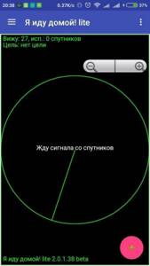
The application will also save the necessary routes, for example, a mushroom or berry place, on the map and help you return to it again. There are several versions of the program.
Which navigator for the forest is better to buy?
All the nominees presented in the rating demonstrate clear reception of the satellite signal, that is, reliable fulfillment of their main mission. Otherwise, they differ in the list of options, build quality, degree of reliability and design. And most importantly, experts have identified top models with prices ranging from budget to premium. Accordingly, what to buy largely depends on financial capabilities and individual wishes. Based on a comparison of the pros and cons of each nominee, the following results were summed up:
- Kinsmirat WL0023 – the best price for a navigator for the forest without the Internet;
- Garmin eTrex 10 is the people's choice, the most purchased model;
- Yasmart NG1 (mini-gps PG03) – best value for money;
- Garmin GPSMAP 66st – premium model with large memory capacity;
- Garmin GPSMAP 276Cx – the widest functionality, maximum autonomy.
It is better to choose one product from the presented rating according to its further purpose. Devices with a hybrid system for receiving GPS and GLONASS signals have proven themselves well. All presented manufacturers demonstrate the reliability of their products, as evidenced by numerous reviews.
Features of pocket navigators
Pocket navigators have a number of advantages compared to other models of devices and methods of determining the user’s location:
- small dimensions of the device body;
- the ability to determine exact coordinates on the ground;
- light weight of the device, which is convenient for long hikes and limited equipment capacity;
- portability of the power sources used (rechargeable battery or battery with the ability to recharge from a current source);
- the presence of built-in memory for saving data processed by the device;
- ability to determine altitude above sea level;
- using a barometer to obtain additional data on weather conditions;
- receiving data, maps of the area with display on the device display.