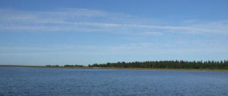
Turgoyak
Lake Turgoyak on the map
Lake coordinates 55.1578,60.0648 Located near the city of Miass, Chelyabinsk region. The lake contains the purest natural water, the quality is close to that of Baikal. It has a round shape. The western coast is significantly indented with capes and bays. It was formed in a deep basin between the Ural-Tau and Ilmensky ridges. Area 26.4 km² Coastline 27 km Maximum depth 34 m Average depth 19.2 m Basin area 76[2] km² Inflowing river: Lipovka, Mekhovaya, Bobrovka, Kuleshovka, Pugachevka, Krutaya Outflowing river: Source
Turgoyak is one of the cleanest lakes on the planet
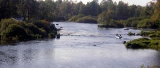
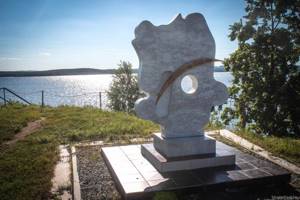
Lake Turgoyak is one of the cleanest bodies of water on the planet. In terms of transparency, it ranks second among Russian lakes (after Baikal) and first among European lakes. In addition, Turgoyak is included in the list of 100 most valuable reservoirs on the globe, is a natural monument and is included in the list of “Wonders of Russia”. According to various sources, the age of this lake ranges from 10 to 15 million years. Translated from Bashkir, “Turgoyak” means “lake located at the top.” This South Ural miracle is located in the foothills of the famous Ilmensky Nature Reserve. It is surrounded on all sides by mountains and centuries-old forest; scientists also distinguish it as a lake with one of the most interesting coastal landscapes in the world. The height of Turgoyak above sea level is 320 meters, its coastline stretches for 27 kilometers, and its depth reaches 36 meters. At the same time, the maximum level of transparency reaches 18 meters. Turgoyak is a huge granite bowl filled with the purest spring water. Since precipitation undergoes a kind of natural filtration through granite, nothing can spoil its purity. It is curious that in Turgoyak there are practically no algae and plankton - they simply have nothing to eat. Therefore, the reservoir never “blooms”. Turgoyak water is healthy and can be drunk directly from the lake. The composition of water gives it many healing properties. Thanks to the radon sources located at the bottom of Turgoyak, where an active ionization process takes place, not only the water, but also the air on the lake is exceptionally clean. There are several versions of the origin of Turgoyak. Some scientists believe that the lake could have formed in the crater of a prehistoric volcano or from a meteorite fall. However, no characteristic volcanic rocks or remains of space rock were found here. Most scientists are inclined to believe that Turgoyak filled a crack in the earth’s crust. But usually reservoirs formed during tectonic changes, such as Baikal, resemble a broken curve in outline. Turgoyak is an almost even circle, the bottom of which is an almost perfectly smooth surface... It is interesting that on Turgoyak, thousands of kilometers away from the sea, sports navigation is surprisingly well developed. The wind on the lake constantly changes direction and strength, which makes the Turgoyak water area an ideal place for yachtsmen. According to athletes, this is the best training ground in Russia before going out into the ocean. Today, not only beginner yachtsmen come here, but also professionals. It is no coincidence that the most famous traveler of our time, Fyodor Konyukhov, found his favorite refuge here and built a house. Having visited 125 countries, Konyukhov says that the most beautiful and at the same time soulful place he has seen is Lake Turgoyak and its surroundings. There are 10 islands on Turgoyak. The largest and most popular of them is Vera Island, which several years ago created a real sensation in the scientific world. Turgoyak still holds a huge number of mysteries. At the bottom of this lake, prehistoric boats, various household items of ancient people, and stone structures similar to pyramids were discovered, the purpose of which is still unknown. Turgoyak is hydrologically connected to the small lake Inyshko, in which, according to legend, the famous treasure of the rebel Pugachev was hidden.
Pervukhin A.A. // 100 interesting facts about the Chelyabinsk region // pp. 18-21.
Sweet
Lake Sladkoe on the map
Lake coordinates 54.5446,63.0202 Located near the village of Kocherdyk, Oktyabrsky district, Chelyabinsk region. This is a small lake, it is located on the territory of the Kocherdyksky reserve. The water in Sladkoe is very soft, alkaline, and characterized by high mineralization. At first taste, this water seems slightly sweet, but the persistent taste is salty-alkaline. Area 0.32 km² Volume 0.0004 km³ Greatest depth 1.8 m Average depth 1.25 m Type of mineralization brackish Salinity 12.5 ‰
Uvildy
Lake Uvildy on the map
Coordinates of the lake Located in the Argayashsky district, Karabashsky and Kyshtymsky urban districts of the Chelyabinsk region. Near the northern shore of the lake there is a village and the railway station Ripus
There are radon sources near the lake; the waters of the lake also contain increased concentrations of radon and are classified as high-radon.
Area 68.1 km² Volume less than 1.08 km³ Coastline 117 km Greatest depth 38 m Average depth 15.6 m Salinity 250–300 mg/l Transparency 6–8 m Basin area 196 km² Inflowing river Kosaya Outflowing river Uvildinskaya ditch
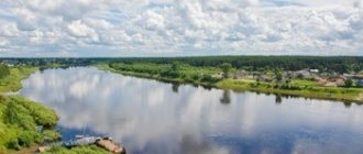
Lake Turgoyak in the Chelyabinsk region
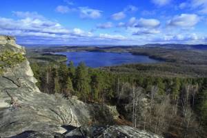
A distinctive feature is water transparency: it is the second lake in the country in terms of this indicator. Turgoyak is considered the coldest lake in the Southern Urals: the water here warms up only in mid-July, and only in very hot weather. But here there is always clean air and excellent training! It is located next to the village of the same name. Area – 26.4 km², average depth – about 20 m, coastline stretches for 27 km. It is fed by precipitation and small rivers and streams flowing into it. Vera Island and its megaliths are popular tourism destinations. There are many recreation centers on the shore.
Lake Uvildy in the Chelyabinsk region
One of the largest lakes in the Southern Urals, located in the north of the Chelyabinsk region, its area is dotted with many islands. Lake Uvildy is pear-shaped in outline and has a rocky bottom. In the summer, the water warms up quite slowly due to the presence of underground springs; it is classified as the most valuable reservoirs in the world in terms of purity and oxygen saturation. It is located in the Argayash region. It is convenient to get there from the Ripus railway station, which is located on the northern shore of the lake. Area – 68.1 km², average depth – about 15 m, coastline – 117 km. Notable places: Goloday and Vyazovy islands. In the immediate vicinity of the lake there are about a hundred places for recreation: guest house “Island”, “Dacha Designer”, “Rainbow” Ave.
Lake Zyuratkul in the Chelyabinsk region
The very first place in beauty is occupied in our region by the Zyuratkul National Park, which is located near the city of Satka in the Chelyabinsk region. Is a reservoir. Part of the national park. Area - 13.2 km², average depth - 3.4 m, maximum depth - about 12 m. The water has a dirty tint, as the lake is fed from streams with sources in swampy areas. There are mountain ranges and coniferous forests around. A nearby attraction is the geoglyph “Elk”. Nearby there is a paid pond “Fisherman’s Orgasm”. Camp sites: “Mountain House”, “Taiga House”, etc. The beauty of the landscapes and Lake Zyuratkul is closely intertwined with monuments to various fairy-tale heroes. Near Zyuratkul there is a park with real pirate ships and a nursery with fawns and huskies. Prak is open to visitors all year round. A visit will cost approximately 1,000 rubles (includes 14 hours of excursion, round-trip transportation, medical insurance).
Lake Kaldy in the Chelyabinsk region
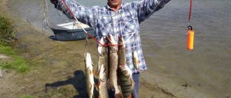
Lake Kaldy is located in the Kunashaksky district of the Chelyabinsk region. Located near several villages, including near Big Taskino. Area – 17.9 km², average depth – about 5 m, maximum elevation is 7-8 meters. The shores and bottom of the lake are sandy, the water is slightly salty. A popular place for fishing and catching crayfish. Part of the coastline is covered with reeds. The rest of the territory is forest, places for swimming, recreation centers and cottages: “Kaldinka”, “Country of Lakes”, “Silver Key”, etc. On the southern coast there are parking lots for cars and tents, as well as paid beaches.
Lake Itkul in the Chelyabinsk region
Located near Upper Ufaley. Area – 30.1 km², average depth – about 8 m. Visiting well-maintained beaches is paid. There are sports grounds, toilets, and boat rentals. Part of the coast is flat. The part is steep with low mountains around the perimeter. The island "Aultash" is assembled from stones and boulders. The attraction nearby is Shaitan-Kamen. Recreation centers: “Uralelement”, “Metelitsa”, “Ural Coast”, etc.
Lake Sladkoe in the Chelyabinsk region
Located near the village of Kocherdyk. Area - 0.32 km², greatest depth - less than 2 m. The water has a salty taste, is rich in minerals, and is considered beneficial for the skin, like local mud baths. They attract tourists, but the infrastructure is poorly developed. There are no fish or algae in the lake. There is a forest complex of the same name, which is also a recreation center. There are places for wild camping.
Lake Elovoe in the Chelyabinsk region
It is located one and a half kilometers from Chebarkul. Area – 3.2 km², average depth – 8 m, coastline – 10 km. The banks range from flat to steep. It warms up well thanks to the wind protection and small size. There are three islands. Recreation centers and guest houses: “Elovoe”, “Kamenny Bereg”, “Spring”, “Ural Dawns”. You can rent everything for a comfortable stay: from barbecues to bathhouses.
Lake Akakul in the Chelyabinsk region
It is located almost at the intersection of Kyshtym and Ozersk. Area – 10 km², average depth – about 5 m. There are small islands, the largest in the center of the reservoir. Boat rental is available. There are mushrooms and berries in the forests nearby, and the Akakul tract is located a kilometer from the coast. Along the shore there are: a health complex of the same name, a holiday home “Zvezdny”, a tourist base “Sosnovaya Gorka”.
Sinara in the Chelyabinsk region
Located in Kasli district. Area – 24.4 km², average depth – about 8 m, coastline – 26 km. The Shumikha River connects Sinara with Lake Okuncul. A nearby attraction is the church in Voskresensky, built in the first half of the 19th century. A popular holiday destination is the “Country House” base. There is a cafe, a landscaped beach, entrance and all services, including parking, are paid.
Lake Sugoyak in the Chelyabinsk region
Located in the Krasnoarmeysky district. Along the shore there are the following villages: Slava, Novy, Lazurny, etc. The area is 13.4 km², the average depth is about 4 m. The lake has a round shape, the eastern shore is not suitable for swimming and other recreation, as it is swampy and overgrown with reeds. The beaches are wild without additional services and amenities. There is a hotel of the same name, the “South Coast” tourist center and other accommodation options by the lake.
Lake Kumkul in the Chelyabinsk region
Located in the Argayash district. Area - 5.9 km², average depth - about 6 m. There are birch groves around, there are areas with reed thickets. The depth increases smoothly. The bottom is mostly sandy. The banks are lined with recreation centers and cottages: “Aquapark Kum-Kul”, “Aviator”, “Avtobusnik”, “Chaika”. Some are open all year round. There is a lot of entertainment (slides, playgrounds), a fee is charged for everything.
Lake Chebarkul in the Chelyabinsk region
The city of the same name is located on the eastern shore. Area - 19.8 km², average depth - about 2.5 m, greatest - 12 m. Fluctuation in water level throughout the year - more than a meter. There are several islands and peninsulas. In 2013, parts of the Chelyabinsk meteorite fell on the territory of Chebarkul. Recreation centers: “Yuzhuralstroyservis”, “Rodnichok”, “Rassvet”, etc. There are camping areas.
Lake Smolino in the Chelyabinsk region
It is located in two districts at once - Sovetsky and Leninsky. The area is 21.7 km², the average depth is about 4 m. There are villages, gardens and tourist centers along the coast. Popular hotels: Smolinopark Hotel and Beryozka. There are several beaches, all paid. The most equipped is “Sunny Beach”: sand was specially brought, sports grounds, a couple of cafes, children’s attractions and other amenities.
Lake Alabuga (Kaslinsky district) in the Chelyabinsk region
Located near Kasli. Area – 8.8 km², average depth – approximately 3 m. It has the shape of a drop. The water is fresh. A small part of the coastline is swampy. Fishing lake is a popular tourist destination. There is a country club of the same name. There are many convenient places for tents near the shore. Surrounded by forest-steppe and mixed dense forests.
Lake Arakul in the Chelyabinsk region
Located near Vishnevogorsk. Area – 3 km², average depth – about 5 m. A nearby attraction is the Arakul Shikhany. There were sites of ancient people here. The rock is also used for training rock climbers. The lake is fed by the Kaganka and Olkhovka rivers, as well as a mountain stream. A popular holiday destination is the Arakul Village complex. Here you can rent a boat or sleigh, play sports, or rent a sauna at any time of the year.
Lake Bolshoi Kisegach in the Chelyabinsk region
Located near the city of Chebarkul. Area - 14.2 km², average depth - about 12 m, maximum depth - 34 m. The geography of the lake is varied: a dozen large islands, several bays, flowing rivers, indented shore. It is a natural monument. There are camp sites and hotels in relative proximity.
Lake Kasargi in the Chelyabinsk region
Located in Sosnovsky district. Area - 14.5 km², average depth - about 5 m. The bottom of the eastern coast is rocky, otherwise sandy. On the western side there are areas with reeds. The water is brackish, but the mineralization is insignificant. A popular holiday destination is the Beryozka tourist base. There is a paid beach with a minimum of services and amenities, as well as affordable prices.
Lake Gorkoye (Uvelsky district) in the Chelyabinsk region
Located near Khomutinino. Area – 4.2 km², average depth – almost 3 m. Water mineralization is increased. It is considered a healing natural site. Local mud is also actively used in cosmetology. The Ural sanatorium exploits all the medical capabilities of the lake: from a healthy climate to water produced under the Uralochka brand. The shore is not built up. Lots of places for wild tourism.
Lake Podbornoe in the Chelyabinsk region
Located in the Uvelsky district. Area – 1.25 km², maximum depth – 3 m. The lake is fed by precipitation and underground springs. A popular holiday destination is the boarding house “Forest Lake”. A rich list of services: gym, beach, bathhouse and others. Near the lake there is a source of mineral water, not inferior in composition to Essentuki. Local silt and clay are also used for cosmetic purposes.
Lake Peschanoe (Shelomentsevo) in the Chelyabinsk region
Shelomentsevo is located on the eastern shore. On the opposite side there is a dense forest. The lake is also called by the name of the village. Area – 1.42 km², average depth – slightly more than 4 m. The water is fresh, reeds have captured part of the coastal zone. Recreation centers: “Good Elk”, “Horizon”, “Luch”, etc. There is a children’s camp “Beryozka”. Next to it is the best beach on the coast.
Lake Argazi in the Chelyabinsk region
Located in the Argayash district. The lake became part of the reservoir of the same name, formed on the Miass River during the construction of the dam. Area – 84.4 km², average depth – 12 m. The water level varies within 6 m. The forest almost reaches the high tide line. There are islands, some partially flooded. Popular recreation centers: “Beryozka”, “Aloha” and about ten more.
Lake Bolshoi Kuyash in the Chelyabinsk region
Located near the village of Ognevskoye. Area – 22 km², average depth – 3 m. The bottom near the western shore is muddy with an abundance of snags, otherwise sandy. The water is brackish and has high transparency. The lake is connected through an isthmus to Maly Kuyash. There is a fishing farm. One of the most popular holiday destinations is the Sova camp site. There are many convenient sites for tents.
Goluboye (Kaolin quarry) in the Chelyabinsk region
The place is located 90 km from Chelyabinsk near the city of Kyshtym. It is a former kaolin quarry. The water that flooded it has a characteristic azure hue. The lake is often called the “Ural Bali”. The maximum depth is about 7 meters; due to the high concentration of clay and minerals, there are no fish in the reservoir. In 2011, industrial development of the quarry was stopped, and the site became a popular place for wild recreation.
Lake Sungul in the Chelyabinsk region
Located near Vishnevogorsk. Area – 11.5 km², average depth – 2 m, greatest – 8 m. Connected by channels with other lakes. One of the cleanest in the Urals. The water is rich in minerals. The bottom is mostly muddy. There are about 20 islands. The coast is steep in places, covered with rocks, and there are cliffs. Nearby there is a sanatorium of the same name and several tourist centers.
Lake Bolshoy Elanchik in the Chelyabinsk region
Located in the Chebarkul region. The area is 5.8 km², the average depth is about 4 m. The Gryaznukha River flows in and the Kundurusha River flows out. There are two islands and one large peninsula dividing Elanchik into two sectors. The eastern shore is riddled with pencil pits: graphite was mined here in the past. There are many places to relax: the Alyonushka sanatorium, the Green Light camp site, Chelyabvtormet and others.
Lake Etkul in the Chelyabinsk region
It is located in the Etkul district near the village of the same name. A relict forest grows on the opposite bank. Area – 4.5 km², average depth – about 2 m. Shape like a bean. Through the isthmus it has a connection with Lake Khokhlovaty. The map has undergone many changes since its inception. This also applies to recharge from now dry rivers. A recreation center has been built on the shore.
Lake Uzunkul in the Chelyabinsk region
Located in Sosnovsky district. Area – 4.2 km², average depth – about 3 m. The lake is fed by precipitation and when the snow cover melts. The water is very clean and brackish. The coast is uneven, there are rocky areas. Algae has taken over part of the lake. Fishing is varied, there are even special places for donkeys. There are several holiday villages in the area. One of the most popular recreation centers is “Kamyshi”.
Lake Treustan in the Chelyabinsk region
Located in the Krasnoarmeysky district. Area – 15.2 km², average depth – approximately 2 m. The coastline is indented, there are wetlands and thickets, and springs gush out. The water is almost opaque, salty, and there is a lot of flooded forest and snags in it. Depending on the time of year, the water level varies significantly. There is nowhere to stay nearby, but there are many places for wild tourism.
Lake Dolgoe in the Chelyabinsk region
It is located 8 kilometers from Kasli. Area – 10 km², average depth – approximately 3 m, the shape of the lake is elongated. There are bays. The water is clear. People come here mainly for fishing. You can stay in the cottage complex of the same name or in the “Tourist” recreation area. There are also parking lots equipped with awnings, camp baths and other necessary minimums.
Lake Tishki in the Chelyabinsk region
It is located near the villages of Malye Tishki, Dubrovka and Surakova. Area – 18 km², average depth – approximately 2.5 m. Fresh water. In it, especially near the shore, there are flooded snags and even large debris. The bottom, like the coast, is sandy on the side of the villages, otherwise it is mostly muddy. The hunting base and the Fisherman's House are popular places to stay.
Text: ChelMami
Tags
Chebarkul
Lake Chebarkul on the map
Lake coordinates 54.9609,60.3274
Located in Chebarkul district. The city of Chebarkul is located on the eastern shore of the lake. On February 15, 2013, a meteorite fell into the lake. The largest piece of the meteorite, weighing 570 kg, is kept in the Chelyabinsk Museum of Local Lore. Area 19.8 km² Volume 0.154 km³ Greatest depth 12 m Average depth 2.3 m Type of mineralization fresh Salinity 0.3679 ‰ Basin area 169 km² Flowing river Elovka Water system Koelga → Uvelka → Uy → Tobol → Irtysh → Ob ь → Kara Sea
Records of the Chelyabinsk region
Dear readers, I suggest you get acquainted with the main records of the Chelyabinsk region. In the future I will prepare similar articles for other Ural regions.
Highest point
The main peak of the Chelyabinsk region is Mount Bolshoi Nurgush. Its height is 1406 m. This is one of the peaks of the Nurgush ridge. Located in the Zyuratkul National Park.
Lowest point
The lowest point of the region is considered to be the valley of the Uy River on the border with the Kurgan region. Its height above sea level is only 102 m.
Longest ridge
The Urenga ridge is considered the longest mountain range in the Chelyabinsk region. The length of this ridge is about 65 km.
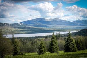
The highest mountain lake
Lake Zyuratkul, located at an altitude of 724 m above sea level, is considered the highest mountain in the Chelyabinsk region. To be fair, it is worth noting that there are higher lakes in the mountains, but they are quite small in size.
The largest lake
The largest lake in the Chelyabinsk region by area is Uvildy. Its area is 68 km2. The bowl of Lake Uvildy stores more than 1014 million cubic meters of water - this is the largest value in the region.
Deepest lake
Uvildy is also the deepest lake in the Chelyabinsk region. Its depth is 38 m. Although some sources call the deepest lake Tashkul (34 m), located near the more popular Lake Itkul.
The saltiest lake
The salt concentration in Lake Soleny Kulat is 116–118 g/l (according to some sources, reaches 150 g/l). It has the status of a hydrological natural monument of the Chelyabinsk region.
The largest reservoir
The Argazin reservoir is the largest in the region. The area of its water surface reaches 113 square meters. km. Built on the Miass River in the 1940s to supply water to Chelyabinsk.
The longest river in the region
Within the Chelyabinsk region, the Miass River has the longest length - 384 km.
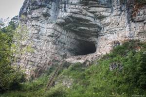
Longest cave
Danko Cave is the longest in the Chelyabinsk region. Its length is 2840 m with an amplitude of 61.5 m. This cave is located on the banks of the Sim River. Accessible only to experienced speleologists, this is the most difficult and dangerous cave in the region. Previously, Sukhaya Atya (2130 m) was considered the longest cave.
Deepest cave
The record holder in this category is the Shumikha Cave on the Ai River. Its depth is 107 m. Previously, the record was held by the Komsomolskaya cave (78 m). True, after the closure of the bauxite mines and the cessation of pumping water, the Shumikha cave went under water.
The oldest art gallery
In the Ignatievskaya Cave on the Sim River there are ancient drawings that date back to the Paleolithic. Their age is 10-14 thousand years.
The largest natural monument
The area of the Sanarsky forest with relict pine forests is 26,294 hectares. The total length of the border of this natural monument is 82.52 km.
The most unusual source
On the banks of the Sim River near the city of Minyara there is a pulsating karst spring. It is known by two names - Jumble or Lost Key. It belongs to the type of so-called intermittent sources, which are capable of increasing and decreasing with a certain period. A real miracle of nature, the analogues of which are unknown to me in the Urals.
The most densely populated and sparsely populated places
The highest population density is in the cities of Chelyabinsk, Magnitogorsk and Korkino (more than 1000 people per km2). The lowest population density is in the Oktyabrsky and Bredinsky districts (6.3 people per km2).
The oldest settlement
The oldest existing Russian settlement on the territory of the Chelyabinsk region is the village of Russkaya Techa, Krasnoarmeysky district (1692).
Oldest cities
The earliest cities to receive city status were Chelyabinsk and Verkhneuralsk (in 1781).
People living only in the Chelyabinsk region
Nagaibaks live compactly only in the Chelyabinsk region. They are an ethno-religious group of Tatars, identified as a separate people. They speak the Nagaybak dialect of the Tatar language. Unlike the Tatars, they are Christians. They have the status of a small indigenous people. The center of the Nagaibaks is the village of Ferchampenoise - the regional center of the Nagaibak district of the Chelyabinsk region.
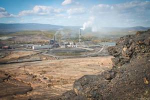
The dirtiest city
In this nomination, the undisputed leader is the city of Karabash. Thanks to copper smelting, the area in and around the city is poisoned. Karabash is often called the dirtiest city on the planet, although this is not true. Driving through Karabash, depressing lifeless landscapes open up.
The sunniest city
The city of Troitsk is considered the sunniest city in the Urals and one of the sunniest in Russia. The average annual sunlight here is 2218 hours.
The highest mountain city
Usually the highest mountainous city in the Chelyabinsk region is called Zlatoust - due to the impressive elevation difference within the city limits (more than 200 m). Its height above sea level is 538 m. However, the height of the city of Bakala is even more significant - 590 m above sea level.
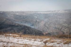
The deepest quarry
The deepest quarry in the region is located in the city of Korkino. The depth of the Korkinsky coal mine is more than 500 meters.
The largest nugget
On October 26, 1842, serf worker Nikifor Syutkin found a nugget weighing 36 kg 21 g at the Tsarevo-Alexandrovsky mine near Miass. This is the largest nugget preserved in the entire history of gold mining in Russia. For its shape it was called the “Big Triangle”.
The richest mineral resources
In the Ilmen Mountains near the city of Miass, 268 minerals and over 70 rocks are known. For the first time in the world, 18 minerals were discovered in Ilmeny. The Ilmensky State Nature Reserve was created here.
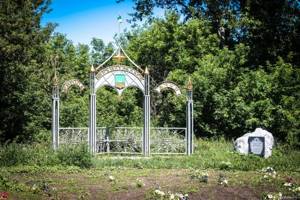
The most famous meteorite
On a planetary scale, the Chelyabinsk region became known to the world after the fall of a large meteorite on the morning of February 15, 2013. Then the shock wave caused numerous destructions. The meteorite's fall was recorded by numerous video cameras. The filming spread all over the world. No other meteorite that has fallen to Earth can boast such fame. The main part of the celestial body fell into Lake Chebarkul. A monument was erected on the shore of this lake, and the largest fragment of the meteorite recovered from the bottom of the reservoir can be seen in the Chelyabinsk Museum of Local Lore.
Thank you for attention!
Pavel Raspopov
Smolino
Lake Smolino on the map
Lake coordinates 55.0902,61.4397
The lake is located on the territory of two districts of Chelyabinsk - Leninsky and Sovetsky. Smolino is located within the city. Despite the status of a natural monument received in 1969, the lake is subject to anthropogenic influence. Wastewater contaminated with organic substances, heavy metals and petroleum products is discharged into its waters, and the shores are littered with household waste. However, the huge reservoir is popular among holidaymakers.
Dimensions 4 × 8 km Area 21.7 km² Volume 0.108 km³ Greatest depth 6.8 m Average depth 3.7 m Type of mineralization sodium chloride Salinity 2 ‰ Basin area 85.4 km²
Itkul
Lake Itkul on the map
Lake coordinates 56.1525,60.5203
The lake is located 20 kilometers from the city of Verkhny Ufaleya. The distance to the border with the Sverdlovsk region is only 5 km, to Chelyabinsk - 120 km, and to Yekaterinburg - 70 km. One of the beautiful places in the Middle Urals. It is a natural monument.
The lake is surrounded by low mountains. The villages of Dautovo and Itkul are located on the banks. Dimensions 7 × 5 km Area 30.1 km² Volume 0.0234 km³ Greatest depth 16.6 m Average depth 7.8 m Basin area 154 km² Flowing rivers Dolgaya, Shardatma, Zyuzelka, Karabaika, Kamenushka Flowing river Istok
Arakul
Another natural monument is located near the town of Verkhny Ufaley and the village of Vishnegorsk. The area of Arakul is 3 square kilometers, the average depth is 5.3 meters, the greatest is 12 meters.
On the shore of the lake there is a rock massif called Arakul Shikhany, more often it is simply called Shikhan. This is an amazing rocky ridge with an interesting relief formed by many years of water and wind.
Arakul and Shikhan are very popular among vacationers from various regions, as well as from other countries.
Spruce
Lake Elovoe on the map
Lake coordinates 54.9956,60.3033
The lake is located a few kilometers from the city of Chebarkul and 85 km west of Chelyabinsk. The reservoir has a slightly elongated round shape. There are three islands on the lake. The water in the lake is warm. Since 1969, the natural site has been given the status of a hydrogeological monument.
Dimensions 2.2 × 1.9 km Area 3.12 km² Coastline 9.8 km Type of mineralization hydrocarbonate class transitional from soda to sulfate-sodium type Transparency 4 m Inflowing Gudkovka River Outflowing Elovka River
Akakul
Lake Akakul on the map
Lake coordinates 55.6194,60.6546
Lake Akakul belongs to the Argayash district of the Chelyabinsk region and is located 50 km from the administrative center of Argayash. The reservoir, curved by small bays, stretches from southeast to northwest. Within the boundaries of the water area there are several small islands; 200 meters from the western shore there is a large island with dense vegetation. The chemical composition of clean and clear lake water contains a whole complex of microelements.
Morphometry Area 10 km² Greatest depth 12.5 m Average depth 4.8 m
Kumkul
Lake Kumkul on the map
Lake coordinates 55.4272,61.1195
Lake Kumkul is located within the boundaries of the Argayash district, 35 km northwest of Chelyabinsk. Popular place for recreation and fishing. The shores of the lake are mostly open, built up with numerous recreation centers and holiday villages.
Dimensions 2 × 3.09 km Area 5.9 km² Greatest depth 8.2 m Average depth 6 m Water: brackish. Salinity: 1.8 g/l. Water class according to salt composition: hydrocarbonate-sodium.
Types of lakes
A special type is represented by karst lakes, which arose on the site of karst sinkholes and failures. An example is lakes Krugloe in the vicinity of Chelyabinsk and Borovushka near the village. Etkul.
As a result of changes in the direction of river flow, floodplain lakes are formed in oxbow lakes. They can be found in the valleys of the Urals, Gumbeyka, Miass, Techa and other rivers. In the Trans-Urals, along with fresh lakes, there are many salt lakes, the sum of ions in which is 5-10 g/l. The maximum salinity of lakes in the southeastern regions reaches 100 g/l or more - Tauzatkul, Soleny Kulat, Lavrushino.
Many lakes in the Chelyabinsk region have valuable balneological properties. Combined with favorable climatic conditions and picturesque nature, the Chelyabinsk region has exceptionally great opportunities for organizing sanatorium-resort treatment and expanding recreation centers.