Our huge country is famous for its rich natural resources. These are delightful forests, amazing flora and fauna, as well as a huge developed water network. Rivers are a source of life and fresh water for the entire population of the planet.
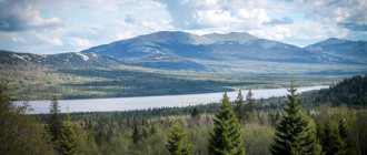
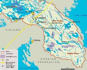
The Vuoksa River is one of the most beautiful rivers of the Karelian Isthmus. It is an unusual water system, including a network of lakes, channels and canals. The river connects Lake Saimaa, located in Finland, with Lake Ladoga, located in the Leningrad region.
Vuoksa River: flow map
The river begins in Finland in Lake Saimaa. Then it crosses the Salpausselkä ridge and forms the Imatra Falls. After this, its bed gradually increases and forms a lake, turning into a narrow channel. After the village of Vuoksa it divides into two branches. The northern branch passes into Lake Balkhanovskoye, and then after the village of Vasilyevo it is divided into numerous channels that form Lake Vuoksa. The Tikhaya channel and the Vuoksa channel emerge from it, which flow into Lake Ladoga. The southern branch flows into Lake Sukhodolskoye, from which flows the Burnaya River, which flows into Ladoga. The arms connect at Lyubimovskoye Lake, forming a horseshoe shape. From it the waters again flow into the river branches.
Geographical information
Vuoksa is a river flowing through the territory of Finland and the Leningrad region of Russia. Belongs to the Lake Ladoga basin. In Novgorod chronicles and census books, its lower course is mentioned as Uzerva, that is, New Lake.
In fact, Vuoksa is a wide river passing in two places through narrow artificial canals. It originates from Lake Saimaa (Finland), located at an altitude of 74 m above sea level, and crosses one of the terminal glacial moraines, the Salpausselkä ridge, forming the Imatrankoski waterfall in Finland (until the 20s of the 20th century there was a waterfall in its place), where one of the two Vuoksa hydroelectric power stations is located in Finland.
After crossing the border with Russia, the river is blocked by two more hydroelectric dams - Svetogorsk and Lesogorsk. In the area of the village of Baryshevo, the Vuoksa channel widens significantly, turning into an elongated lake with a leisurely flow, up to 2.5 km wide. It ends near the village of Losevo with the stormy Losevskaya channel, which flows into Lake Sukhodolskoye (length 32 km, width 3-4 km).
Not far from Losevo, the modern southern branch of the Vuoksa is separated - the Vuoksa-virta, an oxbow channel flowing from Lake Balakhanovskoye, flows into the main channel from the north. The southern branch flows into Lake Ladoga near the village of Solovyovo by the deep and fast Burnaya River, starting from Lake Sukhodolskoye. The “Northern Branch” after Lake Balakhanovskoye continues with a number of lakes and shallow channels, where after the watershed the flow direction changes from southern to northern. In the area of the Tiverskoye settlement, the shallow channels end, and the northern branch of the Vuoksa again becomes a full-flowing lake.
After the village of Vasilyevo, the branch is divided into two narrow fast channels - Belichya and the channel, carrying their waters past the village of Melnikovo. They flow into the vast Lake Vuoksa, with numerous islands and bays. The northern branch is divided into two channels again - the main one, within the city of Priozersk, which is more full-flowing, about 4.5 km long, and the small one, which goes out into Ladoga to the north - the Tikhaya River, the length of the Tikhaya River is 6 km. Both channels begin at the eastern end of Lake Vuoksa.
The total length of the river is 156 km (of which 143 km in Russia), the average water flow is 684 m³/s.
The Vuoksa River, being the second largest tributary of Lake Ladoga, has a significant impact on the state of the Ladoga - Neva River - Gulf of Finland ecosystem. The ecological state of the Vuoksa River, due to its significance and uniqueness, requires special attention. Natural factors and anthropogenic impacts usually cause changes in the river ecosystem.
Large cities located on Vuoksa: Imatra (Finland), Svetogorsk, Kamennogorsk, Priozersk.
"Finnish Vuoksa"
The river originates in the Finnish Lake Saimaa, located at an altitude of 74 meters above sea level. Not far from the lake, the Vuoksa River forms one of the most beautiful waterfalls in Finland and Europe as a whole. The Imatra Falls, whose height reaches 82 meters, is also the largest in Europe.
In 1929, a hydroelectric power station was built in the area of the waterfall, and the river was directed into a new channel. The strong and powerful Imatra Falls amazes tourists with its beauty and charm. It is very popular from May to October. It is during this period that you can enjoy the full power of the waterfall and see how fast jets of water crash against the stones, creating thousands of refreshing water splashes, sparkling in the sun’s rays with millions of colorful tints. In addition, every vacationer who comes to these places during the tourist season, as well as on the eve of the New Year and Christmas holidays, can see an incredible water show, accompanied by light illumination and delightful musical sounds of Sibelius compositions.
Vuoksa
Vuoksa is a river flowing through the territory of Finland and the Leningrad region of Russia. Belongs to the Lake Ladoga basin.
The Vuoksa River is a lake-river system, in fact it is a river passing through artificial canals, lakes and streams. Vuoksa flows from northwest to southeast. The river starts from Lake Saimaa near the city of Imatra, which is located in Finland. Further it flows through the Vyborg region. Near the village of Baryshevo, the bed of the Vuoksa River turns into an elongated lake with a slow flow. It ends near the village of Losevo with the Losevskaya channel, which flows into Lake Sukhodolskoye and from there the Burnaya River flows into Lake Ladoga, 1.5 km from the village of Pereprava in the Priozersky district of the Leningrad region of Russia.
Settlements. Leningrad region of Russia: Vyborg district: Svetogorsk, Lesogorsky, Ponds, Granitny, Kamennogorsk, Ostrov, Bor, Zemlyanichnoye, Slavyanskoye, Perevoznoye, Shcherbakovo, Gremuchiy Sluice, Baryshevo.
Priozersky district: Kolokoltsevo, Varshko, Shumilovo, Gromovo, Bobrovka, Olkhovka, Udaltsovo, Lugovoye, Zaporozheskoye, Pereprav.
Routes (access roads). At the source the river is crossed by a Finnish road. Behind the village of Lesogorsky, to the right of the river there is the A124 highway which goes to the city of Kamennogorsk. On the section of the river between the settlements Sluz Gremuchiy and Varshko, road H200 runs on the left of the river, and road A122 on the right of the river. Further from the village of Varshko, roads H199, H193 approach the river. At the mouth of the river there is a road P34 and a road P33.
Main tributaries. The largest left tributaries of the river: Slavyanka (Savijoki), Unterniska, Kopanets, Vuoksa-Virta, Fedorovka. The largest right tributaries of the river: Storozhevaya, Bulatnaya, Volchya, Gladysh, Tikhaya, Vyun.
Relief and soils. The Vyborg region is located on the territory of the Vyborg Lowland on the Baltic Shield. In this area, rocks of the Early Proterozoic period emerge close to the surface, which are covered with lacustrine-alluvial deposits of the Quaternary period. Most of the region is part of the Baltic-Ladoga landscape district, where flat terrain predominates. Characteristic glacial landforms are “ram’s foreheads”.
The terrain of the Priozersky district is a wooded lake-swampy plain. The surface of the plain is mainly hilly and ridged. Most of the territory of the Priozersky district is located in the Vuoksinskaya and Ladoga lowlands.
This area mainly contains podzolic soils, with poor humus and significant acidity. The main soil-forming rocks are sand, clay and slurry.
Vegetation. The area through which the Vuoksa River flows is occupied by forests, mainly coniferous trees - pine and spruce.
Hydrological regime. The length of the Vuoksa River from source to mouth is 156 km, of which 143 km is in Russia. The drainage basin area is 68,501 km². Water flow 684 m³/s. The height of the source at sea level is 74 m. Near the village of Baryshevo, the width of the river bed is up to 2.5 km. There are four hydroelectric power stations on the river: two in Russia (Lesogorskaya and Svetogorskaya) and two in Finland. The river's food supply is mixed - snow, rain. The river freezes in December and opens at the end of April.
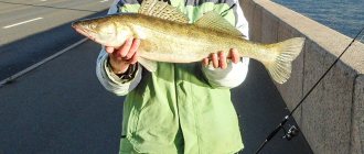
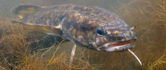
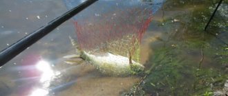
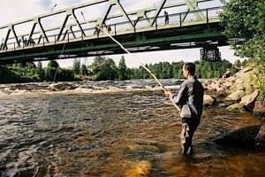
Ichthyofauna. The river has a rich fish fauna. Among the fish species found in the river are: salmon, roach, trout, whitefish, sockeye salmon, vendace, pike, smelt, bluefish, bream, rudd, silver bream, asp, catfish, perch, pike perch, burbot, sturgeon.
Water quality. Nowadays, Vuoksa is considered the cleanest river flowing into Lake Ladoga. Its water is of drinking quality.
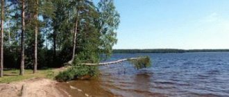
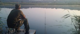
Tourism and rest. Not far from the source, on Vuoksa, there is the Imatra Falls. Its height is 82 m. It is considered the largest waterfall in Europe. Not freezing even in severe frosts, the fast flow of water from the waterfall was used to build a hydroelectric power station in 1929. In this regard, today the Vuoksa River flows along an alternative channel. However, every day - during the tourist season from May to October, as well as before Christmas and New Year, a light and musical show takes place in this place with music and rays of light. Also preserved on the river are fortifications that are more than centuries old; they are currently being restored. Along the shores of lakes Vuoksa and Sukhodolskoye there were fortifications of the Mannerheim Line, which played a tragic role during the Soviet-Finnish War. The Vuoksa River is rich in fish. Many people come to the river to fish, go boating and relax in nature in the fresh air and near a clean river.
Reference Information.
Length: 156 km. Basin area: 68,501 km² Basin: Lake Ladoga Source: Lake Saimaa. Location: Imatra city, Finland. Coordinates: 61°13′29.36″ N. latitude, 28°47′18.46″ e. village Ustye: Lake Ladoga Location: village Crossing Priozersky district of the Leningrad region of Russia. Coordinates: 60°37′26.12″ N. latitude, 30°30′28.16″ e. d.
Vuoksa River, Leningrad Region. Branches of the river
Vuoksa is not only an incredibly beautiful river, but also clean. Its waters are so transparent that even the smallest pebbles at the bottom of the reservoir can be seen through their thickness. On the territory of our country in winter, it is covered with a thick layer of ice and thaws only in April, when spring fully comes into its own. The Vuoksa River in the Leningrad Region stretches for 143 kilometers.
It flows into Lake Ladoga in the form of two water branches. The northern branch flows into the lake near Priozersk, the southern branch first passes through Lake Sukhodolskoye, then flows into the Burnaya channel. Today the water level in the northern branch of the Vuoksa has dropped significantly. The reason for this is the overgrowing of lakes that feed the river. This fact was first registered back in 1980, when the topographic map of St. Petersburg and the Leningrad region, where Lake Balkhanovskoye is indicated, was replenished with new islands-thickets, which did not exist 20 years ago. In the lower reaches of the northern branch you can see the remains of the ancient Karelian fortress “Tiverskoye Settlement,” built in the 9th century. Lake Vuoksa, famous for its picturesque bays and bays, is also located here.
On the shore of the lake is the ancient city of Korela, which was renamed many times. The fortifications of the city were created more than 5 centuries ago.
The southern branch is still being formed. Along Lake Sukhodolskoye, which stretches for 32 kilometers, a six-meter terrace of boulders has formed. Further, through the Burnaya River, the Vuoksa flows into Lake Ladoga.
Hydrography
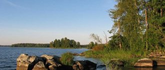
The lake covers an area of 108 km², of which 15 km² are islands.
The origin of the lake basin is glacial. Retreating, the glacier left deep grooves on the granite shores of the lakes, polishing some areas into the famous “ram’s foreheads”.
The shallowest stretch is Priozersky, with a predominant depth of about 5 meters. It is separated from the neighboring Nekrasovsky Reach by the islands of Chudny and Bolshoy Sredny. The bottom of the Nekrasovsky Reach in the central part is a depression up to 15 meters deep, which begins a kilometer from Bolshoi Sredny Island and ends at the strait separating the northern tip of Oleniy Island from the mainland. The third reach is Krotovsky, the most extensive in area. It is limited by the islands of Bear, Svetly and Oleniy with a whole group of unnamed islands. Its bottom is replete with depressions 15 and 25 meters deep. The prevailing depth is about 5 meters and only 0.5 - 1.5 kilometers from the eastern shore there is a narrow winding depression. Its bottom is hidden under a 10-meter layer of water. Another stretch of Lake Vuoksa is Sinevsky, it stretches between Oleniy Island, the Maryinsky Peninsula and the shore of the lake on which the village of Sinyovo is located.
In general, Lake Vuoksa is considered shallow, with an average depth of 5.1 meters. The bottom is covered with a layer of brown or gray silt, rocky in places[2].
The main flow of the lake comes from the rivers flowing into it, in particular the largest river of the same name, Vuoksa. It continues its journey to Ladoga, flowing out of the lake in the Priozersk region.
Riverbed
Vuoksa is simply an amazing river. During its existence, its channel was able to change its direction several times. Until 1818, excess water from Lake Sukhodolskoye, located in Finland, was constantly discharged into the Vuoksa riverbed. During the flood of 1818, its waters washed away the surrounding areas, which led to a drop in level by 7 meters. As a result of this decline, Vuoksa changed its direction. In 1857, the northern branch of the river, which had been the main branch until that time, partially dried up, which again changed the flow.
Oz. Vuoksa, b. Vuoksa and other rivers and lakes of the Karelian Isthmus
Oz. Vuoksa - r. Vuoksa - lake Sukhodolskoye - r. Burnaya - lake Ladoga - lake Gusinoye - lake Otradnoe - r. Pioneer - lake Komsomolskoye - r. Vuoksa - lake Vuoksa.
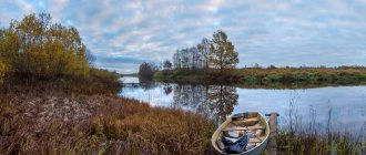
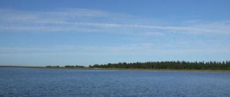
Lake Vuoksa is the largest and one of the most beautiful lakes of the Karelian Isthmus. Its area is 108 square kilometers, of which 15 square kilometers are made up of numerous islands of various sizes and configurations. Water, rocks and forest create magnificent landscapes. The length of the route is 250 km. Seasonality – May 15 – September 1. The beginning and end of the route is the city of Priozersk. Access by train from St. Petersburg. A convenient place to assemble kayaks on the shore of the lake. Vuoksa, 150 m from the railway platform. From Priozersk you should go west, adhering to the direction signs and buoys of the motor ship line Priozersk - Yarkoye - Gory. If you do not go to Yarkoye, then on the large stretch you need to head for Cape Verde - to the southwest and further along the ship conditions at the mouth of the Vuoksa. The Vuoksa River originates from Lake Saimaa in Finland and, after passing 143 km through the Leningrad region, flows into Lake Ladoga. At the beginning of the 19th century, Vuoksa had access to Ladoga only at Priozersk, and from the lake. Sukhodolsky had a flow only to Vuoksu. From Ladoga and its tributary - the river. Taipole - the lake was separated only by a low sandy ridge. To shorten the route from Vyborg to Lake Ladoga, in the middle of the 18th century an attempt was made to connect the lake. Sukhodolskoye with Ladoga via a canal. The work that began was not completed, but the plan was nevertheless realized: in May 1818, during a period of powerful flood, a stream of water broke through the dam that separated the lake. Sukhodolskoye from an abandoned canal to the river. Taipole, and broke into Ladoga. Lake water level Sukhodolsky fell 7 meters. In 1857, an attempt was made to connect Vuoksa with Ladoga. But the waters of Vuoksa poured into the lake. Sukhodolskoe, without bringing any benefit for navigation, since the Losevsky waterfall was formed, and the Vuoksa channel towards Priozersk became shallow. Now the Vuoksa flows into Ladoga through three branches: the southeastern one - through the lake. Sukhodolskoye and the Burnaya River (main) and two northern ones - near Priozersk and the village. Brigade. Upon entering Vuoksu, you should follow the signs of the river situation to the bridge near the village. Mountains where the navigable section ends. After the bridge, the first obstacle is a small waterfall from the dam of a destroyed mill. In low water you will need to carry along the right bank, in high water you will need to navigate against the current. Higher up, Vuoksa widens, flowing through a series of lakes. There are many pitfalls in the channel and you need to walk with caution, especially in areas overgrown with reeds, always sticking to the left bank and cutting off individual bays. Soon on the left bank there is a village. Melnikovo. If you need to go into the village, it is better to stop at the small beach on the left bank. The next settlement (on the left bank) is Vasilyevo. Having passed Vasilyevo, you should move along the left bank to the bridge on the road leading to Melnikovo. On the right bank behind the highway, the remains of an ancient fortress - the Tiverskoye fortification - have been preserved. In 1414, the fortress was captured by the Swedes and destroyed. Until 1857, Tiversk stood on an island, but after the northern branch of the Vuoksa shallowed, it ended up on the mainland. To this day, the fortress rampart has been preserved on the eastern and partially on the southern sides of the former island. During low water, the Vuoksa dries up in this place, and from here the so-called Tiver Portages begin: the first - from the bridge along the left (along the course) bank 130 m, the second and third - along the dry riverbed 30-40 m, the fourth - 100 m along the path. Having finished the drift, you should go, sticking to the eastern shore, and in the next flood approach Cape Friendship, the southern part of which ends in a huge granite slab. Longer than Vuoksa flows through the lake. Balakhanovskoe, which can be reached through a narrow passage through the reeds, starting on the left near the island. Having entered the lake, head south along the eastern shore to the confluence of the Vuoksa. Oz. Balakhanovskoe stretches from north to south for 7 km, and is shallow. The average depth is 2.9 m. In unstable weather, it is better to stay closer to the shore - with the wind, a steep, overwhelming wave quickly rises. Beyond the lake, the path goes along Vuoksa past islands and granite rocks. In some places the old fairway is marked by granite pillars with metal poles. Having reached the confluence of the old and new channels of the Vuoksa, it is worth making a stop on the right (along the way) sandy bank, covered with a young pine forest, and then go east along the left bank along the wide flood of the Vuoksa to the village. Losevo. Approaching the territory of the Losevo tourist center and without going beyond the line of the piles of the old bridge (behind them a complex rapid begins), you need to land on the left bank and inspect the threshold. A group that has sufficient experience in passing rapids can pass the rapids, moving first along the right bank, and after the highway bridge immediately move to the left bank and, walking along it, finish passing behind the railway bridge. Inexperienced groups are better off making a diversion – 1 km along the left bank, through the territory of the Losevskaya tourist center along the road, and then under the railway viaduct to the pier. Next, the route passes along Lake Sukhodolskoe, which stretches in a narrow ribbon from west to east for 40 km. The shores of the lake are high, covered with mixed forest at the water's edge, and a little higher with pine forest. There are sandy beaches. During the war, a defense line ran along the northern shore of the lake and Vuoksa. All that was left was trenches and blown-up pillboxes. From the southeastern part of the lake flows a small (10 km) rapids river - Burnaya, which flows into Lake Ladoga. The banks of the river are high, steep, and covered with bushes. The forest is far away. 1 km from the source the rapid begins, and in order to have time to disembark and inspect it, you need to go out to Burnaya and stay near the right bank. It is also convenient to use it to pass the threshold (600 m). After viewing, an experienced group can pass the threshold along the edge of standing waves. Having passed the rapids, you should go to the left bank and walk along it to the mouth. Below on the Burnaya there are no obstacles, and before it flows into Ladoga it expands, forming a small lip. Fishing is prohibited on Burnaya, as Ladoga salmon come here to spawn. In good weather, you can go out to Ladoga and turn left, north, and walk along the shore. After 1.5 km, in the area of a small cape, where the forest comes close to the water, there is a convenient place for camp. If bad weather strikes and the group does not have time to wait it out, it is necessary to climb upstream along the right tributary of the Burnaya River. Vyun and walk along it to the village. Zaporozhye, from where buses go to the station. Sosnovo line St. Petersburg - Priozersk. Then you can sail, focusing on the large cape, rounding which you can enter Cheremukhinsky Bay and walk along the shore to the impassable channel in the lake. Gusinoye. At this point you need to land on the shore (an excellent sandy beach) and make a portage to the road leading along the bay. From here we can offer 2 options for continuing the route. The first is to drag along the road (or drive up) 3-4 km to the southern tip of the lake. Gusinogo. This is one of the most beautiful lakes of the Karelian Isthmus, with high banks covered with pine forest. The lake is a protected lake; to pass through you need to have a route book; fishing and stopping along the banks are prohibited. You need to go to its northwestern end and make a second portage, bypassing the fish factory facilities. Next, the path passes along a three-kilometer channel - Poganka - from the lake. Otradny to Gusinoye. It involves demolition of the bridge, the mill dam and a number of wiring. The second option is to go out onto the road and take passing transport to the lake. Otradny. Oz. Otradnoye is the second largest on the Karelian Isthmus. Its area is 72.6 square kilometers. The ruggedness of the banks is insignificant. There are several islands in the south. On the transition from Ladoga to the lake. Otradnoe should be taken the whole day and spent the night on its shore. In the morning, if the weather is calm, you can cross the lake in the shortest direction, heading towards the northwestern shore, towards the cape, which is a narrow strip of stones with sparse trees. Then turn northwest from the cape and walk along the coast to the village of Plodovoye. Further the course lies to the west, to two small islands in the middle of the reach, and then to the cape, near which the village and the Otradnoe railway station are located. When crossing the lake, you need to carefully monitor weather changes, remembering that there are frequent winds on the lake that raise large waves. Having rounded the cape, you should swim in the direction of the railway bridge, where a channel into the lake begins among the reeds. Komsomolskoe. The channel (Pionerka River) is shallow, winding, 8-9 m wide, passable for kayaks. The current is weak. The banks are overgrown with forest and bird cherry bushes. There are 2 obstacles on the river - a dam (40-50 m run-over) and at the exit to the lake a small 50 m long shirker (wiring). Oz. Komsomolskoe stretches from south to northwest for 14 km with a maximum width of 2 km. The lake is very picturesque, the shores are covered with pine forest, there are many granite outcrops (lamb's foreheads). The river flows from the northwestern part. Cheerful. It is wider and deeper than Pioneerka, and the current is fast. It will also involve the removal of a destroyed dam (40 m). Veselaya flows into one of the lakes of the Vuoksi system. Having entered the lake, you need to head north, sticking to the eastern shore until the fork and further along the right channel (Belichaya) - to the northeast. The channel is shallow and rocky, so ships need to be navigated in places. When the channel turns east - on the left bank of the village. Bykovo. Further the channel turns to the northwest and beyond the village. Belichye flows into the lake. Vuoksa. From here the path goes north. You should stick to the islands on the lake. Vuoksa and the western coast of Deer Island, after which head for Priozersk, where the route ends. If it is necessary to shorten the route, it is convenient to interrupt it in the village. Otradnoye. From the shore to the station - about 1 km. At the same time, the length of the route will be reduced by 110 km.
Recreation and fishing on Vuoksa
The Karelian Isthmus, where the Vuoksa River runs, is a popular tourist destination in northwestern Russia. The local nature is famous for its beauty and uniqueness. Delightful white nights, picturesque lakes, a huge variety of fish, mushrooms and berries.
A holiday on the Vuoksa River will allow you to enjoy its beauty and charm. Its nature and relief are so changeable that they sometimes surprise even experienced travelers. The gentle banks turn into high stone terraces, on top of which pine trees of unusual shape proudly rise. Their trunks are sometimes so intertwined that they resemble amazing sculptures. The local recreation centers “Quiet” and “Romashki” are popular among vacationers.
The main thing that the Vuoksa River is famous for is fish. Quiet river backwaters, where nature seems to have stepped out of artists’ paintings, are famous for their wide variety of ichthyofauna. Pike, ruffe, perch, bleak and roach - the variety of fish is impressive. Well, local bream are known far beyond the region. In cold seasons, burbot fishing is very popular. In addition, you can catch expensive trophies here. Salmon, whitefish and trout are very common in these areas. Numerous travel lovers, fishermen, and in past centuries even emperors prefer the Vuoksa River. Fishing in these places is simply unforgettable.
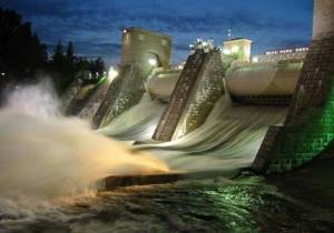
Hydroelectric power stations on the Vuokse River
The elevation difference from the source to the mouth of the Vuoksa is 72 meters, with the main difference of 60 meters occurring in the first 26 kilometers of the river. It was on this site that the first wooden dams were built from the end of the 19th century - the prototypes of modern hydroelectric power stations.
Today there are four hydroelectric power stations on Vuoksa: two in Finland - Tainionkoski and Imatra hydroelectric power stations, two in Russia - Svetogorsk and Lesogorsk hydroelectric power stations, which in 1949 formed the Vuoksa hydroelectric power station cascade. In 2005, the cascade became part of the generating capacities of OJSC TGC-1.
On April 24, 1964, an agreement on the border water systems of the USSR and Finland was signed and the Joint Soviet-Finnish Commission on the use of border water systems was created. Today, the regimes for using Vuoksa to ensure the operation of hydroelectric power plants are regulated by agreements between Finland and Russia dated July 12, 1972 and October 26, 1989.
The Vuoksa hydroelectric power station cascade is a key source of power supply to the Karelian Isthmus. The annual production of both cascade stations exceeds a billion kWh of electricity, ensuring the export of electricity to Finland.
Rafting on Vuoksa
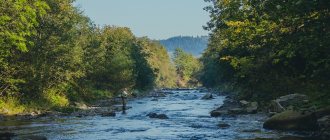
Extreme sports enthusiasts are attracted to these places by breathtaking rafting. Going on a water trip, you will be able to feel all the strength and power of the river, as well as its wayward character. Calm and majestic, slowly flowing towards the unknown, it instantly becomes stormy and restless, with many harsh obstacles and thresholds that make you hold your breath and enter into battle with nature.
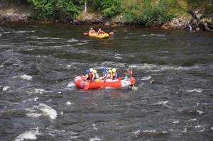
Anyone can go on an amazing journey along the water surface of this beautiful river. You will be able to enjoy the delightful nature of the Karelian Isthmus, where crystal lakes and majestic rivers lie. There is an atmosphere of freedom and a delightful aroma of pine freshness. By rafting down the river, you will be able to fight the water elements, as well as visit historical places located on its islands. Local stretches and the beauty of picturesque islands await you.
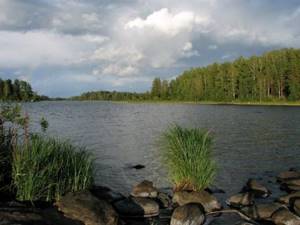
Lake Vuoksa
The name Vuoksa is also borne by a separate lake, located before the confluence of the large Vuoksa into Ladoga. It has many islands, the largest of which is Deer Island. On the shore of the lake there are Priozersk, Sinevo, Gory, the village and the tourist base Yarkoe (Finnish: Suotniemi - swamp cape).
It was the lake and the channel connecting it with Ladoga that were mentioned in the Novgorod chronicles under the name Uzerva (from Karelian Uuzijärvi, “new lake”). Subsequently, in the 17th century, after the population of the shores of the lake was replaced from Karelian to Finnish, the name of the lake became Finnish and began to sound like Uusijärvi (Finnish: Uusijärvi). This name, during the massive renaming of hydronyms of the Karelian Isthmus in the middle of the 20th century, was changed to the modern one - Lake Vuoksa.
Festival of Friendship
On June 28-29, 2014, the festival “Vuoksa - the River of Friendship!” took place, which was organized in the village of Losevo. Vacationers were treated to incredible sports competitions, trips on kayaks and catamarans, rafting, all kinds of relay races and a varied entertainment program. For those who love outdoor recreation, a concert of bard songs was organized. In addition, here you could choose tourist equipment and buy memorable souvenirs.
The Vuoksa River is the embodiment of incredible beauty and amazing power. It will give you a wonderful holiday filled with natural harmony and many exciting adventures.