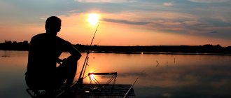
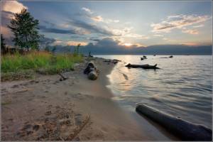
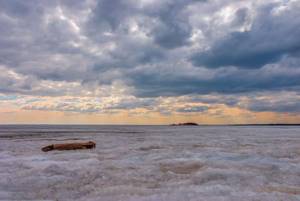
I want to talk about catching chebak in the Ob Reservoir. And even if this small fish does not become a unique trophy in your fishing career, you are guaranteed to get pleasure!
First of all, I would like to report on the fishing features that I have discovered over the past two or three years. Chebaks, roaches, and small breams stopped reacting negatively to noise and light-colored clothing.
I had the opportunity to fish in calm weather from the bridge at a depth of 70-90cm. The peculiarity of that fishing was that I fished with winter fishing rods and jigs. I practically saw a school of fish eating up my bait and hunting for a worm.
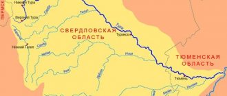
Ob Sea on the map of Russia
The Ob is a wide (in some places even knotty due to large expansions) strip that separates the Siberian Cis-Urals from the rest of Siberia (flows between a small fold and a lower geological plate). Has a huge western bend. Passes through 3 regions and 2 autonomous districts of the Russian Federation. However, the Novosibirsk reservoir is located precisely on the adjacent territory of the region of the same name and Altai - in the space between the southern agglomeration of Novosibirsk (Sovetsky district) and the regional center of Kamen-on-Obi (Kamensky and Krutikhinsky districts of AK).
The length of the designated river episode is exactly 200 kilometers. The greatest width is 21 km (in the area of the villages of Sosnovka on one side and Leninskoye on the other). The height of the water surface is 113 meters above sea level. Volume – 8,800 sq. km. Depths range from 7 to 25 m. Surface area - 1,082 sq. km. In the end, we point out that the filling took place after the construction of the hydroelectric station. Throughout 1959. In its process, not only villages and settlements fell under water, but even the historical core of the town of Berdsk. And only 10,307 yards! The speed of runoff currents reaches 1.5 meters per second. The design river flow at the site is 1,637 cubic meters/second. This gives rise to a hydroelectric power plant capacity of 455 MW. The length of the coastline is as much as 599 kilometers.
The strategic Novosibirsk-Barnaul highway runs along the “sea” perimeter (on both sides of the reservoir). Adjacent to the edges are dirt driveways that connect to asphalt highways near the villages. It offers guests a railway track on the right bank (stations Obskoe More, Beregovaya, Rechkunovka, Berdsk, Morozovo, Selskoe, Obskoy Bay, 52 km to the beaches of the lower part of the “sea” and Berdsk Bay). 2 bridges - railway and automobile-pedestrian (at the beginning and at the end of the artificial water area, there are some bays). 10 ferry crossings.
Among the spacious bays of the man-made basin are Berdsky Bay (the most elongated) and the mouth of the Bolshaya Channel. Sosnovy, Goluboy, Karakansky, Ust-Aleussky, Ordynsky and Krutikhinsky backwaters (the latter is both long and wide, the depth is decent). Also visit Pichugovo More (the widest bay). The largest ledges between the bays are the Berdskaya Strelka (Berdsk), the spit of the river. Miltyush and Karakansky Cape. The height of the Riviera is different everywhere. For example, a hydroelectric dam has a height of 33 m. The lower (lake-like) part is raised slightly less than the upper (which already belongs to the Altai Territory). The general fluctuation in the height of the ravines is from 2 m (in the arms) to 100 m (in the “tops”). The highest point of the drop is in the town of Kamen-on-Obi.
Fishermen lined up on the Ob Sea for a selfie with a huge pike perch
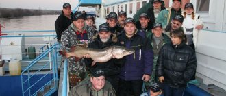
“Photos of a 7.8 kg trophy pike perch, which was caught on January 10, 2021 at the Ob Reservoir in the area of the Ordynskaya crossing, have already spread across the Internet and groups. This trophy was caught in my hole,” wrote an experienced fisherman from Novosibirsk under the nickname ivan007 on the website Fishingsib.ru.
According to Ivan, he and his comrades left Novosibirsk at 6.30 in the morning. The fishermen headed towards the Horde crossing. There were a lot of people on the ice of the Ob Sea.
10/03/2016 photo
A resident of Novosibirsk caught a giant pike perch, but lost to her husband
“What kind of pike perch can you take from the Ob Reservoir? Everyone knows for certain that it is at least 33 cm. It is this size that counts. Actually, this is what we mainly catch, the one that is released less and is caught rarely,” says Ivan.
Fishing for the Novosibirsk residents somehow didn’t work out at first. “I’m standing there fishing, no one is catching and I don’t have any approaches in the echo sounder. My partner and I decide to move away from the crowd to the side where there is no one. I’m catching the first and second at once, both are in the standings, but they’ve already noticed, they ran and drilled, there are approaches, but they don’t want to take them anymore,” continues the fisherman.
Then Ivan and his friends began to move around the reservoir, moving away from the crowd of fishermen. Somewhere around lunchtime, the men found a clean nickel and decided to check it. “While fishing, I decided to look on my phone to see where we were approximately and how far we had gone. While I was downloading the application, this was the blow. I hit it well, I’m holding the phone in my hands, but I have to wind the coil - it’s very inconvenient with the phone in my hands. As a result, I remove the echo sounder sensor from the hole and throw the phone nearby on the snow. I start to bring the fish to the hole, but it doesn’t come in. Gennady, who was fishing nearby, runs up and takes the fishing line, I begin to feel resistance. The fish presses down, unwinding the reel, the clutch cracks, I start trying to pull it to the hole - the tip of the whip of my rod breaks, but it brought me to the hole. Vladimir comes up and tries to get the fish directly with his hands. It doesn’t work,” says Ivan.
The fishermen were also unable to pull out their catch with the hook. Then the Novosibirsk residents began to carefully drill, breaking and removing the ice with shovels. Soon many fishermen ran up to Ivan’s hole - some with a shovel, some with a hook. As a result, a mouth appeared from the hole. It became clear from it that a pike perch had been caught.

“But there was no way to get it out, so they continued to drill. In the end, they dragged me through with three hooks. He was incredibly huge. The scales showed 7.8 kg. This is a trophy,” Ivan admires.
According to ichthyologist, employee of the Institute of Systematics and Ecology of Animals of the SB RAS Elena Yadrenkina, pike perch is one of the most desirable prey of the amateur fisherman. Firstly, because fishing for pike perch is a highly sporting activity; and secondly, the meat of this fish is considered a delicacy.
“Pike perch have powerful fangs alternating with smaller teeth sitting next to them. The color is dominated by softer gray tones. Of the prickly fish, pike perch is the largest predator,” says Elena Nikolaevna. “Record holders reach one meter and weigh 10-15 kilograms.”
According to amateur fishermen, 1.4 times more pike perch are caught per year than the volume of its reproduction during spawning. “This leads to an annual reduction in its number by almost 1.5 times, and in 2 years almost 2 times, which will ultimately lead to the complete disappearance of this species in all areas of the Ob Sea and its tributaries,” says fisherman Sergei Kirov.
Tributaries and islands
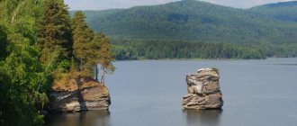
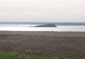
In the Ob Sea (as the reservoir is usually called colloquially), everything inside is arranged the same way as in any other. It has capes, bays and islands. We will list only isolated sections of land (from south to north). Each one is a natural monument in itself.
Korablik (1,500 by 500 m), Zaimishche (4,100 by 1,000 m, floodplain forest), Gusyatnik (2,200 by 700 m, vegetation, swamp), Razdumny (2,000 by 650 m), Sporny (2,000 by 250 m, swampy floodplain growth). Spills (3,500 by 700 m, many bays). Kukuy (2,600 by 450 m, an elongated spit on the eastern water line). An island within the village of Chinggis (6,700 by 1,150 m, on its surface there is part of a settlement). Next come other islands of the Novosibirsk Reservoir. Kamensky (2,800 by 500 m, the most wooded of all, with an internal lagoon), Krasny Yar (2,000 by 670 m, the northern part is separated during floods), Krasnoyarsky Borok (1,600 by 850 m, pine forest), Kamensky (900 at 750 m, arboretum) and the archipelago opposite Novopichugovo-Borovoye (the distance between the outer islands is 26 km). Cowshed (1,400 by 250 m, also quite green, the secret of the name is connected with temporary grazing). There are islands in the urban part, but they do not directly belong to the water area, since they are formed on a narrow section.
Between them, on the river surface of the Novosibirsk reservoir, dozens of smaller pieces of land delight the traveler’s eye (they say they are convenient for fishing). And also difficult-to-pass floodplains. Absolutely all the islands are cut inside by valleys, which are flooded during the period of “high water”. As for the named objects, the channels here are constantly filled. In some places there is exclusively coniferous flora. However, more about biocomplexes below.
The artificial pool is fed by 30 visible branches. These are the Bolshaya Channel and the Blue Bay Channel. There are also tiny islands of the Novosibirsk Reservoir in the named mouth bays. They carry water from the Razdelnaya, Mahalikha, Irmen, Sharap, and Orda rivers. Aleus, Maslyakha, Krutishka, Rozboynaya, Suetka and Sueva. Khrapikha, Sokolovskaya Protoka, Maly Chinggis, Bolshoy Chingis and Khmelevka. Kamenka, Eltsovka, Erestnaya and Glukhaya. Bolshaya Eltsovka, Karakan and Borozdikha. Atamanovka, Tulka, Meltyush, Protoka Sosnovoy Zaliv and Razdelnaya. Dozens of streams flow here. However, the largest Ob tributary on the “sea” section is Berd (it ends with Berdsky Bay and the city of Berdsk). The Berd River from “start” to “finish” is 363 km.
The importance of the reservoir
The Novosibirsk reservoir is used to generate electricity, as well as for the needs of shipping, water supply and irrigation, fisheries, recreation, etc.
The share of the Novosibirsk HPP is approximately 17% of the total electricity generation in the Novosibirsk region. The maximum amount of electricity for the entire period of operation of the hydroelectric power station was generated in 2013.
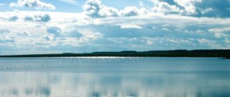
Island in the Novosibirsk Reservoir (Strober / wikimedia.org)
Of great importance is the regulation of the Ob flow, carried out through the construction of the dam. This is related to ensuring a reliable water supply for Novosibirsk, because even in very low-water periods, the water flow in the river is sufficient for the normal functioning of the water intake.
The Ob Sea is also a source for irrigation of the arid steppe regions of the Altai Territory. Thus, its water is used to feed the Kulunda irrigation canal, which goes 180 km into the Kulunda steppe.
With the construction of the dam, navigation conditions have also improved significantly, which is associated with an increase in water levels during the summer low-water period.
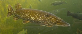
The Novosibirsk reservoir is of fishery importance. This large artificial reservoir has formed its own ichthyofauna. Here you can find commercial fish species such as ide, roach, pike perch, burbot, bream, pike, crucian carp, perch, etc. Valuable fish species that live in the waters of the reservoir: nelma, sturgeon, taimen, muksun, sterlet, etc.
Thanks to its beautiful nature, the Ob Sea attracts a large number of vacationers. On its banks there are many sanatoriums, tourist centers, children's camps, etc.
Flora and fauna
The Ob Sea is surrounded by memorable natural landscapes inhabited by living creatures. As for flora, it exists even on the water surface. Phytoplankton is represented by traditional blue-green and chlorococcal algae. In summer, the water actively blooms. Pine trees grow on the ground (on different edges the original ribbon pine forests have been preserved, to which “brethren” were then planted). Such needles, in case of death, are gradually replaced in some places by birch trees. Speaking about floodplain vegetation, it is worth mentioning the forest-steppe areas of the eastern bank that smoothly descends to the Ob. There are also black alder and aspen here. The appearance of the reservoir caused many plants to disappear and reduced the populations of fur-bearing animals.
The most common animals of the designated water region are bear, wolf, otter, badger, beaver, fox, hare (hare and hare), marmot, wolverine, wild boar, some fur-bearing animals, roe deer and elk. The predominant birds are various ducks and geese (closer to the water and fields). As well as black grouse, wood grouse, ptarmigan and owls (in pine forests, often turning into deciduous - floodplain).
Therefore, hunting or fishing on the Novosibirsk Reservoir is not the most important pleasure. It is much more profitable and beneficial for the environment to simply enjoy the delights of the local biocenosis. There are no forbidden locations, so it makes sense to take a tent. So…
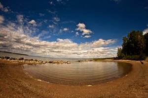
Tourism and recreation on the Ob Sea
The Novosibirsk reservoir, being a champion in several categories at once, cannot but arouse the interest of vacationers from the Siberian regions. And even vacationers from other regions of the federation. Recreational tourism is combined with entertainment and even medical tourism. For a comfortable stay, there are many tourist centers, holiday homes and sanatoriums.
Attractions
- The most extended city bridge in the world was built between the western and eastern halves of Novosibirsk (once there was no contact with each other at all - in the form of 1 metropolis there were 2 cities isolated from each other). The length of the engineering structure is 2,145 meters. It's covered. As you understand, it crosses the water area to which the article is devoted. The diameter here is 896 m - probably the narrowest along its entire length... This miracle connects two metro stations - Studencheskaya and Rechnoy Vokzal. Communications were built in the mid-80s. The technology was not used anywhere else on Earth at that time. Allows the bridge to extend by 50 cm (with temperature changes). It is worth adding that the move will allow you to see the longest (straight) street in the world - the 7-kilometer Red Avenue.
- The pilgrimage should cover such masterpieces of religious architecture as: Parish in Honor of the Annunciation (Novosibirsk, Russkaya Street), Chapel in Honor of the Presentation of the Lord (Berdsk, Zheleznodorozhnaya Street), Church of St. Wonderworker (Nizhnekamenka farmstead), “island” church in Chinggis, churches Epiphany and the Most Holy Theotokos in Kamen-on-Ob. And also a religious building at the mouth of the Kirza stream (Kirza village) and the monastery of God on Stepnaya in Ordynskoye. It is required to add to the list the Orthodox architecture of the Archangel Michael complex (the intersection of Primorskaya and Molodost streets, Novosibirsk). In Krutikha, everyone remembers the St. Nicholas Church (that is, the village has different beauties).
- We will find the “Attic” art space at Berdsky Dead End, 5 (Akademgorodok). We are talking about a point where painting exhibitions, theatrical performances, etc. are held near the water.
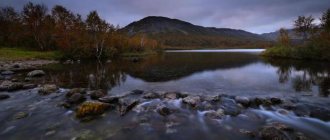
- Natural beauties are a must on an Ob voyage. The most famous include the relic Karakansky Bor with the crystal bay of Marble Lake, the cliffs between the Sovetsky district and Berdsk (“vidovki”), the Blue Bay, the Pine Bay, the panoramic platform in Abrashino, the idyllic peninsula opposite Sokolovo, the network of oxbow lakes opposite Krutikha (colorful meadow landscapes) , an “observation” spot in the town of Kamen-on-Obi. And also ribbon green massifs - Ust-Aleussky, Ordynsky and many island... You will see many equally significant wonders in Berdsky Bay - for example, Berdsky rocks. The Berd River itself leads to the Bugotak Hills and Belovsky Waterfall.
- Berdsky Ostrog is a historical reserve (remains of the ancient core of the town);
- The Culture and Recreation Park “By the Sea of Ob” invites all those who find themselves between the alluvial dam of the hydroelectric power station (Sovetsky district of the city district, length 3,356 m, 3-chamber lock) and the village of Goluboy Zaliv. The waterworks and PKiO are connected by a 700 m long embankment. On warm days, it makes sense to take pictures of the majestic waterworks.
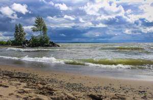
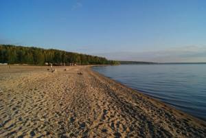
Beaches:
- Zolotoy Bereg - the most popular beach of the Novosibirsk reservoir (lower reaches of the Blue Bay, eastern side - full service, boat station, boarding house, park);
- Zvezda resort (Soviet district of the Novosibirsk agglomeration, Zvezda park, pebble);
- swimming location Horizon Patio (just south of the previous one);
- Sun City (ibid);
- equipped recreation Central-Soldatskiy Beach (near Obskoye More station);
- Chemsky Bor is an unequipped (“free”) beach of the Novosibirsk reservoir, adjacent downstream to the described Zolotoy Bereg;
- Ob Sea swimming pool (southern outskirts of Novosibirsk, traffic police station stop);
- Kirovo-Beregovaya beach (Kirova village, cottage complex “Novy”);
- Sosnovka (northern shore of Berdsk);
- Cote d'Azur (northern coast of Berdsk);
- Dunes-Sandy Beach (Berd beach, famous for its sand, located at Morskaya, 10A);
- beach strip of the inner part of Berdsky Bay - “Shedrikha” and “Green Polyana”;
- Staraya Pristan (Ob coast of Berdsk on Strelka, Krasny Sokol street);
- Berdsk city beach (south of the Yunost camp and Blue Lake of Berdsk);
- On the Stones (west of the Yubileiny children's sports camp, near Berdsk);
- camp beach DOL "Solnechnaya Polyana" (between Berdsk and Sosnovy Bay);
- Zeleny Bor (on the way from Borovoe to Beregovoe, admission is free);
- Marble Lake Bay beach (rural municipality of Abrashino);
- river recreation area Abrashino (to the south);
- beach line of the sanatorium "Paradise Nest" (Nizhnekamenka village, Foma pier);
- wild earthen beaches near Spirino (left bank, Ordynsky district of the region);
- village bathhouse in Vagaitsevo;
- beaches of the regional center Ordynskoye (intersection of Naberezhnaya and Flegonovskaya streets, Obskaya street);
- the town of Lake Molchishche (north of Ordynskoye);
- narrow sandbanks of Borovoye;
- concrete road with stairs near the Kamenskie Plesy hotel (Kamen-on-Obi);
- unofficial city beach of Kamenya-on-Obi (behind the local PKiO).
The listed “sea” recreation areas are different in terms of surface. Earthen with grass, sandy, pebble, small stone. Some of them are famous for the fact that on the other side they overlook tiny lakes. Or on estuaries of a winding shape - like “Marble Lake”.
Wild holiday
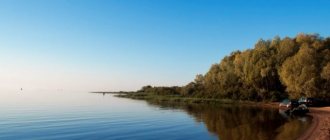
The so-called “wild” holiday on the Ob Sea has no fewer advantages. If you camp somewhere with a tent, you can definitely count on the absence of garbage, silence and communication with nature without commercial intermediaries (in some places there are no recreation centers, no country clubs, no children’s camps, or even equipped campsites). As a result, naturists can become completely naked at coastal points where no “primer” directly leads. You will have to pay for some of the comfort - in such places there is either close pressure against a rocky clay cliff (usually very high). Or the water edge is covered with reeds. And the dense floodplain or coniferous forest “steps” directly onto the waves.
Having assessed the relief, you will understand: the more convenient approaches are on the lower right bank. The beaches in this area have a smooth sunset. And they contain almost no stones at the bottom. They are "childish". And here the train runs (at the end even along the beaches of Berdsky Bay and the Berd River). On the same side, to the south, you will find the huge Karakansky Cape with the relict forest of the same name and “Marble Lake” (the railway does not pass through). But the point of complete solitude on this side is more difficult to find. Closer to the upper reaches of the Novosibirsk reservoir, “tourist” islands appear. "Controversial", for example. And many others no less picturesque. Here the “sea” becomes narrower. And it expands only to break into parts (channels and backwaters). Plavnyami. There is more floodplain vegetation (including reed and emergent vegetation) in this “fishing” part. It is already more difficult to label water as transparent.
What's on the left bank? The coast is cleaner. To the south of the village of Goluboy Zaliv, a “resort civilization” still needs to be found. Take the various exits from Highway 50K-17R. The closest to Novosibirsk is Chemsky Bor. This is the undeveloped half of the embankment of the suburban park “By the Sea of Ob”. In the warm season (especially on weekends), Bor attracts hundreds of people. Upstream, you will meet such a crowd only once - on the beach section of the Zolotoy Bereg complex (meaning the sandiest space on the described side, a mini-park and the only sanatorium specializing in gynecology).
What's next? Blue Bay behind its mouth, the village of the same name and the residential sector Leninskoye is already a “wild” place. Take advantage of this circumstance. And in Ordynsky Bor, most of the points are “wild”.
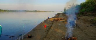
Vacationing as a savage on the Ob Sea is convenient, since natural recreation sites have proven tent sites. Several of them, thanks to bloggers, became known to the general public - “Azimuth”, “Neocom”, “Zvezda”, “On the Rocks”, “Many Strawberries” and on the southern islands. You just need to drive further away from the service (paid) campsite area. But spontaneous sites are located in Sosnovy Bay, on the outskirts of Morozovka, near Zavyalovo...
Rafting often starts closer to Novosibirsk, but not at the waterworks sites! Therefore, the traditional water “start” is considered to be the points from Rechkunovka or from the Berdsky Cape (arrows) to Burmistrovo (on the right bank). Or already from Chemsky Bor to the Blue Bay (on the left bank). The fact is that these two zones have the largest number of vehicle access points. As for the first option, there’s even an electric train to help (the station closest to the water is Rechkunovka). Again, ubiquitous ferries or river “trams”... The water area in the presented section does not have complex navigational directions (shoals, islands in the center of the fairway or smooth waters, unlike the routes at the “top”). You can descend here from such branches as Blue Bay, Berd, Razdelnaya. “Vodniks” are not allowed to use the Bolshaya Channel (at the end it ends with a lock). A regatta in the “sea” is much more popular than rafting, kayaking, and canoeing. For a water journey, it is safer to choose the beginning of a gradual decline in water - days closer to June. You should walk away from the ship's passage. Barges must be avoided at a reasonable distance. However, following the rules often does not protect you from “shifters”: take vests.
This is such a vacation. A person can remain a savage on the Ob Sea for weeks - clean air, saturated with rich aromas. Primers for bicycles and ATVs. A rich selection of berries and mushrooms (even at appropriate times of the year). Chance for a brilliant photo shoot. Alloy. And ample opportunities for all types of fishing. We'll talk about its nuances in the next chapter.
Boarding houses and recreation centers
On the shores of the Ob Sea you can spend a weekend or vacation not only as a savage. Tourists are offered numerous boarding houses and recreation centers. In winter and summer, tourists are welcome at the tourist centers “Blue Lake”, “Brigantina”, “Obskie Prostori”, “Ust-Aleus”. Accommodation there is organized in rooms for 2-4 people, economy-class summer houses, as well as in separate cottages. For entertainment, boat rentals and sports equipment are available, as well as fishing tours and walking tours. As for what makes winter holidays on the Ob Reservoir attractive, it is snowmobiling and winter fishing.
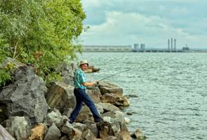
Fishing and hunting on the Novosibirsk Reservoir
The named “resort” reservoir is home to all sorts of ichthyofauna, and all around there are flying game and animals. Whether you are a fisherman or a hunter, there is complete freedom for fishing here.
Fish of the Novosibirsk Reservoir
Fish in the Novosibirsk Reservoir is represented by a list of 40 names, of which commercial ones:
- pike;
- zander;
- crucian carp;
- perch;
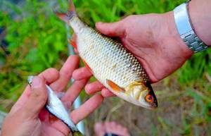
- ide;
- burbot;
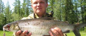
- dace;
- chir;
- peled;
- carp;
- tench.
Fishing on the Ob Sea has its own specifics and folk traditions. Firstly, the locals recognize exclusively pike perch as the main trophy. Secondly, you should only be armed with a thick fishing line - there is always a strong wind blowing on the water. Thirdly, in winter, huge schools of perch live close to the shore - you don’t need to go far out onto the ice. Fourthly, an aboriginal fisherman, who fundamentally does not want to return without a catch, can go to a paid site (“fish storage facility”) on the coast of Karakansky Bor. There will always be giants here. Fifthly, the bottom in some places does not freeze until January, providing the opportunity for winter fishing for large prey.
Fishing on the Ob Sea is fraught with the accidental capture of Red Book fish. It includes whitefish, sturgeon species, taimen, muksun, nelma, lenok, barbel char, and Siberian grayling. Under no circumstances should you use poaching devices or violate the rules of spring spawning. There are a large number of recreation centers with special platforms, fishing equipment rentals, and boats for rent. The basin has stocked lakes. In general, fishing is allowed everywhere except for hydroelectric power stations and some “birth” points of the reservoir.
Hunting grounds on the shores of the Ob Sea
Several hunting grounds of the region of the same name and the Altai Territory adjoin the water edges of the Novosibirsk reservoir. They are concentrated exclusively in the southern thirds:
- "Mayurovskoye" (Iskitimsky section also includes part of Berdsky Bay);
- "Borovoe";
- "Irmen";
- "Obskoe";
- "Tulinskoe";
- "Ordynskoe" (the longest).
In coniferous forests, on the green outskirts of agricultural spaces and in overgrown floodplains (backwaters and lakes) there are various birds: ducks, geese, drakes, wood grouse, black grouse, ptarmigan. Among the animals are bears, squirrels, badgers, wolves, hares (hares and hare), marmots, sables, wolverines, weasels, roe deer, foxes, beavers, wild boars, muskrats, moose. Of these, notable “Red Book” inhabitants are the large jerboa, lynx, otter, reindeer, shrews, long-eared hedgehogs, grebes and loons. Cormorants, pelicans, ibis, oystercatchers, ducks, swans, herons, cranes, owls, all flying predators. The order to open the season contains many restrictions, and the nuances often change...
Where is
The Ob Reservoir is located south of Novosibirsk. It was created artificially. In 1957-1959, a hydroelectric dam was built on the Ob River. At the same time, a huge area was flooded with water. To create the reservoir, more than 15 settlements were moved from their historical places, and after that several new towns and cities arose.
Today, on the shores of the Ob Sea there are Novosibirsk, Berdsk, Kamen-on-Obi, the settlements of Spirino, Krasny Yar, Ust-Aleus and others. At the moment, the surface area of the reservoir is at least one thousand square kilometers. If you measure the length of the reservoir between Kamen-on-Obi and Novosibirsk, you will get more than 200 km. In summer, the sun warms up the water well, and its temperature in the Ob Reservoir can reach up to 28 degrees.
Environmental measures
The Ob Sea gives the best to those tourists who do not disturb the ecological balance of the area. Employees of 2 departments at once ensure that motorists in most fragments comply with the rules of the water protection zone (cars cannot be parked near the water here). Plowing of land, construction, grazing of livestock, placement of land dumps and construction of dams are prohibited.
Fines are also provided for any attempt to arrange an unauthorized landfill on the shore. Scientists from Novosibirsk State University have proven that all of the listed water flows and the Ob water area itself carry high anthropogenic loads. Pollution classes are “conditionally clean”, “dirty” and “very dirty”. Group water intakes use groundwater from reservoir terraces. Small and large enterprises (including agricultural ones) have outdated wastewater treatment systems (or do not have them at all). The issue is being resolved at the level of the mayor of Novosibirsk and the prefects of the adjacent districts. Public organizations gather the local population for cleanup days.
Recommendations for tourists
Now you know what you can do on the shore of the widest natural reservoir in our country. However, some details are missing. We put them at the very end of the review:
- It’s best to relax at the “sea” taiga resort in the period July-August (however, get ready that in the evening the temperature from 27 will drop sharply to 19-18 positive degrees, in addition, there is always a breeze on the “sea” - however, this is to the advantage of yachtsmen) ;
- It is strictly forbidden to engage in fishing in areas where whitefish and sturgeon spawn;
- All-Russian sailing competitions are often held in the waters of the “sea”;
- more than 30 commuter trains run along the route connecting the Obskoe More Railway Station with the stations of Berdsk, Iskitim, Cherepanovo, Dorogino and other settlements;
- If you are driving your car to the right bank, then from the Novosibirsk Hydroelectric Power Station the route should go along the Berdskoye Highway (R-256), leading to Barnaul. After 60 kilometers, turning right, you will eventually reach Burmistrovo. After another 17 km - to Bystrovka. The left half of the water area is accessible along the highway 50K-17R - laid to the town of Kamen-on-Obi (then it also goes to Barnaul). On the way Borovoe, Ordynskoye;
- The Ob section Borovoe - Spirino is recognized as the most picturesque and quiet on the left bank;
- no need to worry about the ferry schedule: the intervals between departures are short;
- Since in most deserted areas the forest approaches the water, take a remedy for midges:
- for those who need full service (locker rooms, showers, cafes, sun loungers and toilets), it is better not to leave the area of the Sovetsky district of Novosibirsk, Berdsk, Ordynskoye, Kamen-on-Obi;
- if you choose the eastern base of Cape Berdskaya Strelka for your vacation, then you can actually combine almost all possible types of tourism: “berry and mushroom”, historical, pilgrimage, beach, extreme, cultural and educational, entertainment, fishing, health and rural (including equestrian) . The lion's share of the entire infrastructure of the reservoir and simply natural monuments is concentrated in this tiny region. Namely, a rope park, service beaches and restaurants. Trails leading into the thickets of the Berdskaya Strelka (it’s good to ride horses or ride bikes here, and in winter go down the hills on a sleigh). There is also a reconstruction of the first Berdsk (“Berdsky Ostrog” - entrance fee). Clinical sanatorium "Parus", as well as boarding house "Forest Fairy Tale". There is a varied recreation area, consisting of service beaches “Remix”, “Sandy Beach” and “Dunes” (everything is available there). The best view of the bridge section of the Berdskoye Highway opens. A restaurant ship operates. In the east of Strelka there is something like rural but aristocratic guest estates (“Old Tower” at the dead end of Berdsky Zaliv Street). Connoisseurs of Orthodox architecture will be interested in the Sretensky Church, built just one and a half kilometers from the described zone. The first stop in this zone is “Popova Street” or “Emerald Town” (this is a 2.8 km walk from Berdsk station).
To study the tidbit of the described phenomenon (the Ob Sea), you just need to get to the “capital” of the 54th region. Any type of transport – the 3rd largest city in the Russian Federation has all types of transport terminals. There are already 3 excursion points available to you. A 2-kilometer beach, an adjacent embankment and the above-mentioned bridge. Other objects are easily accessible by boat, train, bus or minibus.
1
All about fishing in Siberia. On the Ob, in Novosibirsk
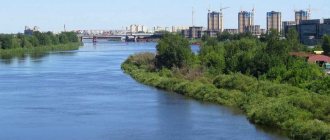
The Ob Reservoir is an artificial reservoir on the Ob, the largest artificial reservoir in Western Siberia. 30 small rivers flow into the reservoir. Formed by the dam of the Novosibirsk hydroelectric power station, filled in 1957-1959. It is located on the territory of the Novosibirsk region and the Altai Territory. Cities on the banks of the reservoir: Berdsk, Kamen-on-Obi, Novosibirsk.
As a result of the creation of the reservoir, the central historical part of the city of Berdsk, as well as several villages of the Novosibirsk region, were completely flooded. Area 1070 km², volume 8.8 km³, length 200 km, greatest width 22 km, maximum depth 25 m, freezes in winter. The Sea of Ob is a place for active recreation and annual sailing competitions for the Russian Cup and the Ob Sea Cup.
HISTORY Start of construction of the hydroelectric dam - 1950. Filling of the reservoir began in 1957. Launch of the first unit and start of operation of the hydroelectric power station - 1957. The design capacity of the station is 455 MW, and the annual electricity generation is 1.9 billion kW/h. The hydroelectric power station building is a complex engineering structure, where 8 hydraulic turbines weighing 1600 tons each and a power of up to 60 MW are installed. The hydraulic structure consists of a concrete spillway dam with a height of 33 m, a crest length of 198.5 m, an earthen dam with a length of 3356 m, an alluvial dam with a length of 1023 m, a three-chamber sluice and a hydroelectric power station building. The Novosibirsk hydroelectric power station is part of the unified energy system of Siberia. Graph of the progress of the levels of the gauging station of the Novosibirsk hydroelectric power station.
RECREATION In spring, the water level in the reservoir is lower. As a result, the sandy bottom of the artificial sea is exposed. The illusion of numerous beaches, reaches and shallow bays is created. But by summer the volume of the reservoir increases, and it all goes under water. Many settlements are concentrated along the banks of the reservoir. Including - Kamen-on-Obi, Krutikha, Maletino, Ust-Aleus, Spirino, Chingis, Kirza, Ust-Khmelevka, Nizhnekamenka, Ordynskoye, Novy Sharap, Erestnaya, Krasny Yar, Zavyalovo, Bystrovka, Tula, Burmistrovo, Berdsk. The pine forests adjacent to the reservoir stretch for many kilometers: Ust-Aleussky, Ordynsky and Karakansky forests. Picturesque nature, clean air and proximity to the sea attract many vacationers here, even from neighboring regions of Siberia. The surroundings of Berdsky Bay are no less picturesque, where recreation centers, dispensaries, and children's health camps are concentrated. In addition to the fact that tent camps are widespread on the Ob Sea, there are a large number of recreation centers. There is also an artificial beach here. Before the construction of the wave-damping dam in 1986, there was intense erosion of the coast. There was also a threat of this spit being washed away by the sea along with the pine forest that protects Akademgorodok and the railway line in this area from the sea. Nowadays there is no longer such intense erosion of the coast that took place before the construction of the dam. Artificial wave-damping structures of a natural type fit more naturally into the shores and create good conditions for their recreational use.
ICHTHYOFAUNA The water resources of the reservoir are used comprehensively for energy, shipping, water supply and fisheries. In the 1990s, the Ob Sea annually provided a catch of 900 - 1200 tons of fish, the main share of which was bream and pike perch, acclimatized back in the late 1950s.
Valuable species of fish and more are found here: pike-perch, perch family; Dace is a small fish, up to about 20 cm long (carp family); Pike fish up to 1.5 in length; River perch. Predatory fish; Roach is a fish of the carp family; Ide is a carp family. Mostly up to 53 cm in length, but they can also be longer. Bream is a carp family. The body length of fish of this species is generally up to 80 cm. Weight is approximately 6 kg. Grayling is a family of salmon. The largest individuals weigh 6 kg. Tench is a carp family. Length ranges from 20-40 cm. There are also up to 70 cm. grow up. Crucian carp is up to 40 cm long and weighs about 2 kg. Carp is a carp family. Burbot is a cod-like order. Up to 120 cm long. Chir is a salmon family. Peled is a salmon family. Length is approximately 50 cm and weight is 2-3 kg. Nelma is a salmon family. A very large fish. Sturgeon is a family of sturgeons. Sterlet is a family of sturgeons. It reaches 40-60 cm and weighs up to 2 kg. Whitefish is a salmon family. Muksun is a salmon family. Weighing up to 8 kg. The most valuable species of fish are listed in the Red Book of the Novosibirsk region: Ob sturgeon, sterlet, muksun, nelma, taimen.
As a result of erosion of the coastline and swamping of the artificial sea, there are practically no suitable conditions for fish reproduction in the reservoir. In summer, due to the high water temperature, blue-green algae and diatoms rapidly develop, absorbing oxygen from the water. Fish parasites are activated. We are killing a lot of fish. All this directly or indirectly affects the well-being of the Novosibirsk reservoir and its fauna. And ultimately - on people's health. Using the example of the Novosibirsk reservoir, it is easy to see that its creation caused more negative environmental and social consequences than the benefits that people expected. The natural sea and its artificial counterpart are not the same thing.