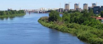
The most beautiful and picturesque places, rich in unique vegetation, inhabited by rare species of animals and birds, are located in especially inaccessible areas of the country. In the southwestern part of the Kola Peninsula, washed by the waters of the White and Barents Seas, beyond the Arctic Circle, there is Lake Imandra, amazingly beautiful and the largest in the Murmansk region.
Geography:
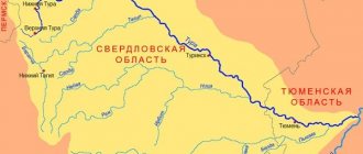
Imandra is the largest lake on the Kola Peninsula. The length of the lake is 109 kilometers, the width varies from 9 to 19 kilometers. The total area of the reservoir is 885 sq. m, and if you subtract the area of the islands from it, it will be 815.5 square kilometers. The lake consists of three reaches: Bolshaya Imandra, Yokostrovskaya Imandra and Babinskaya Imandra. The reaches are connected by the Yokostrovsky and Shirokaya Salma straits.
Bolshaya Imandra is the largest stretch both in terms of length and volume of water (4.6 cubic kilometers, or 42.2 percent of the lake’s volume), and the second in area; it has an elongated shape. The width of its open part varies from 3 to 8 kilometers, and together with Vite Bay it is 16.5 kilometers. More than half of all lake islands (80 out of 144) are located within this reach. Their total area here is 5 percent of the water area. The western shore of the reach is indented and has many lips, of which the largest are Kurenga (Kurenglukht), Monche (Muodzhvuun), Vite (Yitvuun), Kislaya (Soptvuun) and Belaya (Enemanlukht). The eastern, Khibiny, coast is poorly dissected.
Yokostrovskaya Imandra is the first in area (361.9 sq. km.) and the middle reach of the lake in terms of length, volume of water and number of islands. It has an oval-elongated shape and its greatest width is opposite the Okhtokanda Bay - 18.7 kilometers. The lips of Okhtokanda, Zacheechnaya, Tik-lip and Knyazhaya are the largest. There are also numerous smaller bays here. In its western part, the reach is “squeezed” by the Zayachya Salma Strait, which is about 1 kilometer wide. After the construction of the Murmansk-Leningrad highway, Yokostrovskaya Imandra communicates with Babinskaya only through it. Before this, between the Rovat Islands and the southern protrusion of the mainland coast there was another shallow strait - Narrow Salma. Now this strait is blocked by a dam, and Rovat Island has turned into a peninsula.
Babinskaya Imandra has a shape close to round. This is the smallest stretch both in length and in area, volume of water and number of islands. However, it is here that the largest island on Imandra, Erm, is located (25.9 sq. km). The coastline of the reach and its islands is highly indented and forms many lips. The largest of them are: Upoloksha, Cheverez, Kun-chast, Molochnaya, Kamka.
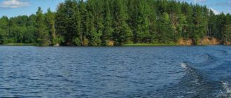
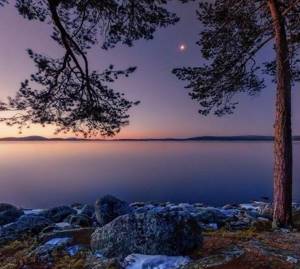
The diversity of the topography and geological structure of the lake's coast and the different effects of water determine the variety of types of its shores. Along the 757 km of coastline, the character of the coast changes very often and forms an infinite number of shapes. However, from the general diversity, five types can be distinguished, between which there are a large number of mixed, transitional forms: rocky, boulder, pebble, sandy and swampy-peaty shores.
Rocky shores are common along the lake. Imandra is quite common in places where hills are directly adjacent to the coast. However, not everywhere the rocks drop directly into the water, since often from the water's edge to them there is a more or less wide strip of shore of other types. Outcrops of crystalline rocks in the form of steep cliffs (buttermilk) are most often found in Babinskaya Imandra, almost exclusively on sections of the coast facing east or northeast. In Bolshaya Imandra, rocky shores are found mainly along the western shore and only in isolated places along the eastern shore.
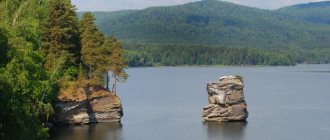
Boulder banks, the most common, form a huge variety of forms, gradually changing from one to another. This type is most clearly expressed on the southern shore of the Yokostrovskaya Imandra - in the Tik-guba area and on the banks of the Zasheechnaya Bay. Flat boulder banks in Bolshaya Imandra are located in the mouth areas of the Monche, Vite and Kislaya bays. On the northern shore of Babinskaya Imandra, flat boulder banks behind the coastal ledge rise gently towards the shore and retain their general appearance, although covered with forest. The most interesting and unique type of boulder bank is boulder ramparts - fences. They are found on a small island near the station. Imandra Oktyabrskaya railway, in Vita Guba, Monche Guba and on many islands. This type of formation also includes the so-called corgi - rocky shoals, consisting of a pile of irregularly shaped boulders and blocks in the open parts of the lake.
Pebble beaches do not, in essence, represent an independent type of coast: there are swell-like accumulations of pebbles, turning into boulder “fences” (Yokostrovskaya Imandra) and flat pebble beaches, turning at a short distance into boulder ones (Babinskaya Imandra).
Sandy shores are much less common than rocky and boulder shores. Loose material in most cases represents later accumulations of weathering products. In addition to small sections of the coast composed of sands, there are two large areas of sediment accumulation. One is along the eastern bank of the Bolshaya Imandra at the foot of the Khibiny (Sandy Navolok), the other is in the westernmost part of the Babinskaya Imandra (Vuondas-lukht - Sandy Lip). By their nature, sandy shores are divided into two groups - erosional and accumulative. Erosion sands are usually composed of layered sands, usually larger and more enriched boulders and pebbles in the upper horizons and smaller ones - up to ribbon clays - in the deep horizons. The bulk of the eroded fine sand is carried away by currents and often forms sandy beaches. This type of shore is well defined near the Yokostrovsky Strait. Accumulative coastal forms owe their origin to three main factors: drift circular and longitudinal currents, surf currents and the action of ice cover. The largest amount of loose material is found along the eastern bank of the Bolshaya Imandra due to the accumulative activity of mountain rivers and streams flowing from the Khibiny.
Swampy-peaty shores are a fairly common phenomenon in Yokostrovskaya and along the western banks of Bolshaya Imandra. By their origin, they can also be erosive and accumulative. Erosion ones are mostly found on the coast of the eastern part of Yokostrovskaya Imandra in the area of Zheleznaya Bay, Voche-lambina and Okhta-Kanda Bay, as well as along the shores of large bays of Bolshaya Imandra. They are a towering low peat cliff at the very edge of the water, carved by the breaking waves and reaching a height of 10-50 cm, behind which there is usually a sedge-sphagnum bog. On the eastern shore of Okhta-kanda Bay, the shore is formed by a peat outcrop 1.3 m high. The accumulation of peat masses and overgrowing of the shore is a clear sign of an accumulative swampy-peaty shore. Peat eroded in outcrops is carried by surf currents along the shore and deposited as a semi-liquid mushy mass at the tops of the lips.
Hydrology:
Lake level and currents:
Since 1934, on the river. Niva, a cascade of Niva hydroelectric power stations was subsequently built, which led to the regulation of flow and the formation of a reservoir. This led to significant fluctuations in its water level. Since 1973, thanks to the commissioning of the Kola Nuclear Power Plant, the water level drawdown of the Nivskye HPP cascade does not exceed 1.5 m.
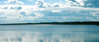
Annual fluctuations in water level also depend on meteorological conditions: the amount and distribution of precipitation, the amount of evaporation, the intensity of snow melting depending on the course of air temperatures. The lake level, reaching its lowest point in April-May, then begins to rise rapidly, reaching a maximum in July. Due to the regulation of the reservoir, the maximum water level remains until freezing. Winds have a great influence on level changes. Northern winds lower the level in the northern parts of the lake, correspondingly increasing it in the southern parts. Conversely, southern winds drive water from the southern parts to the northern parts. Differences in air pressure in different parts of the lake also affect fluctuations in water levels.
Special observations of the waves have not been carried out, but the approximate height of the wave in windy weather reaches 1 m. The nature of the wave in different parts of the lake, due to the location and configuration of the islands and depths, changes quite sharply. In the open, deep parts, when the wind blows along the main direction of the lake, the waves are usually flat and wide. In strong winds, the height of individual waves is not always the same. Usually, behind a large group of smaller waves, two or three high waves pass, giving way again to smaller ones, and their alternation occurs at regular intervals.
Currents in the lake can be divided into two types - permanent, caused by the slope of the lake level to the drainage and the influence of tributaries, and temporary, caused by winds. Convection currents caused by differences in temperatures of different areas and deep layers are small, but undoubtedly are of great importance in the circulation of lake waters. Constant currents towards the source are clearly visible in the narrow straits connecting individual reaches of the lake. In the Yokostrovsky Strait, after a steady north wind, you can observe a small wave standing in one place on calm water, where masses of water returning from the south meet a constant current. The influence of tributaries is apparently great; for example, with a strong southern or southeastern wind, a change in the nature of the wave is observed far from the mouth of the river. Pirengi. They become shorter and sharper with tipping ridges. The existence of compensation currents is indicated by the hydrological profile along the Bolshaya Imandra. Cold bottom water masses move north under the influence of long-term northern winds, which drive warm surface water to the south. These compensatory currents cause mixing of the entire water column and favor the heating of the deep layers of the lake.
During the period of open water surface, the formation of the dynamic regime of the reservoir is largely determined by the wind, which creates drift currents, while runoff currents are of subordinate importance and can be traced only in the estuarine sections of inflowing rivers, the most significant of which are the rivers M. Belaya and Goltsovka. Kuna, Pecha, Kurenga, Monche, Vite and Kurken-yok, and in the Yokostrovsky Strait connecting Bolshaya with Yokostrovsky Imandra. In the reservoir basin, the predominant winds during the ice-free period (in a long-term context) are winds from the northern directions: north and north-west. In 1968 and 1969 The wind distribution corresponded to the long-term average, which determined the nature of the dynamic processes.
The direction of surface currents basically coincides with the direction of the wind, i.e. Southern currents prevail with slight deviations from the wind direction due to the influence of local factors: the outline of the coastline, depth, topography of the bottom of the reservoir, and the presence of a large number of islands. The highest surface velocity according to observational data is 17 cm/sec.
In the coastal areas of the lake at a depth of 5-10 m and in the deep-sea areas - at a depth of 10-15, 30-40 m - reverse (compensatory) currents are observed. A characteristic feature of the current regime in this reservoir is a significant increase in speed with depth.
Studies during the under-ice period in 1970 showed that a weak transit current (2-3 cm/sec) is observed only in the Yokostrovsky Strait; in other parts of the reservoir, currents are not detected instrumentally.
The main components of the water balance are the influx of surface water from the catchment area, precipitation in the form of rain and snow, surface runoff and evaporation. The lack of hydrological research materials and stationary observations of the groundwater level in the lake area did not allow us to identify such a component of the water balance as underground inflow. Complete water exchange in the lake occurs in approximately 2 years.
Temperature:
At the Khibiny meteorological station, observations have been carried out with short interruptions since 1900, but only since 1926 can these observations be considered sufficiently reliable.
Oz. Imandra is a type of moderately cold water body. After the lake is freed from ice, the water mass begins to quickly heat up, and direct temperature stratification is established. In July, further warming of the reservoir occurs, somewhat slower in open parts and faster in shallow water and coastal parts. The temperature transition through 10 °C is usually observed in the third ten days of July. The water layer warms up the most up to 10 m (up to 14 °C, and in some years up to 18 °C); deeper, the temperature drops much more slowly. Sometimes on calm, clear days there is a sharp jump between depths of 5 and 10 m. When the wind is directed along the long axis of the lake, mixing of the waters occurs to a significant depth, so the jump layer becomes invisible. Wind circulation often causes warm surface water to flow downwind and deep cold water to rise upwind.
Relatively high temperatures in shallow bays depend on the influx of warm water from rivers. All tributaries, flowing through numerous small, well-warmed lakes, have a summer temperature 3-4 °C higher than in the lake. The most dramatic change in temperature is observed during the day to a depth of 10 m. Deeper, the temperature change is much less, but still covers a water thickness of up to 20 m.
In August, the air temperature begins to decrease and, accordingly, the surface layers of water begin to cool. During August, temperatures equalize throughout the entire water column, and the difference in surface and bottom temperatures differs by several tenths of a degree. In September, there is already a significant cooling in the air and a further drop in water temperature to 8 °C. In October, the cooling of the water goes even further and by the end of the month there is an equalization of temperatures (4 °C) throughout the entire water column and, subsequently, a transition to reverse stratification. By the beginning of November, all the lips of the lake are covered with solid ice, and by mid-November the open parts of the lake are also covered with ice, although strong winds can break the fragile ice several more times. Under the ice, the temperature varies from 0 °C in the surface layer to 2.6 °C in the bottom layer.
Extreme tourism
Those who want to get an adrenaline rush choose rafting from 2 to 6 categories of difficulty along numerous mountain rivers with dangerous rapids, difficult and relief routes. Testing yourself and your body's abilities while away from civilization is the best way to escape from a comfortable but boring everyday life.
Among the popular and moderately dangerous entertainments, kite surfing has been actively developing in recent years. Riding a board with a paraglider gives you the exhilarating feeling of flying through the waves.
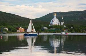
More relaxed travelers can choose sailing yachts and boat trips. The vast territory of Imandra may require several days to cover the entire route and will allow you to enjoy the cleanest air and quaint coastal landscapes.
History and etymology:
Despite its large size and position on the main summer route between the White Sea region and Murman, Lake Imandra appeared on geographical maps quite late. The first mention of the existence of a large reservoir in the interior of Lapland is found on the oldest maps of the North by Olai Magnus, who compiled them in 1539 and designated a large lake. Lacus alba. Many historical geographers identified Lacus alba with the White Sea, but the development of cartographic data confirmed the opinion that Lacus alba is a body of water independent from the White Sea. So, already in 1568, on the map of Jacopo Gastaldo, this lake called Lago Bianco had a flow into the White Sea. On the map of Levin Algut [1594], Lago Bianco had a flow into the Gulf of Finland, but on the Mercator map [1594], Albus lac again had a flow into the White Sea, and at the mouth of the river flowing from this lake, the village of Candelok is indicated (Kandalaksha).
Quite a lot of detail inside Lapland is found in the original map of Simon Van Salingen, compiled based on personal observations in 1601. The lake depicted by Simon Van Salingen does not yet have the name Imandra, but the signature on the Akill map says that it is indeed Imandra, since the western part of the lake was called Akkelaiver by the Lapps.
On the map of Andrei Bureus, compiled in 1611, the Lacus albus body of water disappears, but the details of the sea coast indicate that he used new sources when compiling the map. On the maps of Russia by S. Neugebauer [1612] and G. Gerrits [1613], Albus lac appears again, having a drainage, as on the Mercator map, into the White Sea near Kandalaksha. But already in the next edition of the map of G. Gerrits [1614], a lake is indicated in the upper reaches of the river. Pejcr - probably corresponding to the name of the lake. Pirenga. Only in the atlas of Kirillov [1745] lake. Imandra reappears on the map and from that time on, in one form or another, appears under this name.
In the summer of 1840, the middle part of the Kola Peninsula was crossed by the route of A.F. Middendorf, later a widely known naturalist. He headed along the length of Kola, along Imandra and Niva to Kandalaksha. As the traveler himself admitted, “for topographic surveys I had nothing except an ordinary small hunting compass with a degree circle (without a diopter). All that I could do to survey the area was limited to carefully marking, using a compass, every sharp change in the direction of my path, with an approximate account of the space I traversed, which I kept mainly by the clock.”
Despite this, the map of the route from Kola to Kandalaksha, printed by Middendorf in 1845, turned out to be a much more accurate depiction of the topography of the Imandra basin than the Postal Map published three years earlier. Thus, on the Postal Map the Umba River was depicted flowing from the Imandra and flowing into the Kandalaksha Bay, but Middendorf showed that in reality the waters of the Imandra are discharged into the White Sea by the Niva River.
Significant and interesting results of mapping the Imandra basin were obtained by the Finnish expedition (V. Ramsey, A. Chilman, A. Petrelius, etc., which worked on the Kola Peninsula from 1887 to 1892. The expedition topographer A. Petrelius was the first to identify a number of astronomical points in the central parts of the peninsula and made a semi-instrumental survey of the lake basin. Published by Petrelius in Finland in 1892, the map of the lake correctly conveyed the general outlines of the reservoir, but was not accurate enough in detail. The survey was not carried out by walking around the lake, but with serifs from individual hills, so there are no many details of the coastline - capes, bays, etc.
In 1880, the route of the expedition of geologist N.V. Kudryavtsev, organized by the Russian Geographical Society, passed through the lake basin. Along with geological observations, the traveler made sketches and collected materials on the topography and toponymy of the basin. The Sami guides told him the local names of islands, capes, and bays. Their list took up almost 30 pages in Kudryavtsev’s diary.
By the end of the 19th century, the location of the reservoir was known quite reliably, but the lake itself remained unexplored for a long time. “Lake Imandra remains in many respects completely Terraincognita,” geographer A.S. Grigoriev wrote at the beginning of the 20th century on the pages of the News of the Geographical Society. “No limnological or hydrobiological studies have been carried out on it; neither its depth, nor the structure of the banks, nor its origin are known.”
Work on the study of Imandra was started in 1924 by the first scientific institution in the Russian north - the Murmansk Biological Station. A small expedition consisting of G.M. Kreps, F.E. Belov, F.VKrogius and M.N. Mikhailov headed to the lake, focusing their efforts on the hydrological and hydrobiological study of Belaya Bay and the adjacent part of the reservoir. In 1925, already under the leadership of G.D. Richter, a survey of the lake’s water area was carried out, and in 1926 a “Preliminary report on the work of the Imandra Expedition” was published, which is deservedly ranked among the classic works in the field of Russian lake science.
In the 1960s, when the problem of lake pollution emerged, GosNIORH expeditions carried out a small amount of research and, starting from the 1970s, the Kola Science Center has been conducting long-term in-depth studies of anthropogenic variability in the lake’s ecosystem. Imandra, which include the study of water quality and bottom sediments, flora and fauna communities.
The origin of the name of Lake Imandra has not yet been fully revealed.
According to the famous geographer N.N. Poppe, the name of the lake has a common root with the name '"Imatra". It is possible that the name is very ancient and of non-local origin. The local Lapp name for the lake is “Iveryavr”, which has already fallen into disuse. But, according to the Lapps themselves, this name is also not Lapp, since the word “Iver” does not appear in the modern Lapp language. It is possible that this is an ancient Lapp word, the meaning of which is currently forgotten. There is an assumption that originally there was “Avvy-eur” - an open lake. On some Finnish maps at the beginning of the century the name lmantero was sometimes found (map SuomenJleiskarten, 1901) and only the western part of the lake - Babinskaya Imandra - retains the name Akilaiwer.
S.B. Vasiliev believes that given the transport significance of the lake in the life of the Lapps, mainly in winter, it is highly likely that it was originally called Innmandera, which means an ice continent or a large ice expanse (inn - ice, mandera - continent). Later the name was transformed into a more harmonious one for Russian settlers, which is how it has remained to this day.
A. Kazakov writes that the term “Imandra” was used by the Sami to refer to large lakes with a winding coastline, with many islands and bays that have a parallel orientation.
There is also a legend about the origin of the name of the lake. Imandra is the name of a girl, the daughter of a hunter who once lived on the shore of a small lake. Like her father, the daughter hunted, was fast, beautiful, and her laughter woke up the sleepy mountains. One day, her joyful laughter was heard by a young hunter who lived on the other side of the mountains. He followed this laugh and saw Imandra. Enchanted by her beauty, he forgot that he was walking through mountains with deep gorges, could not take his eyes off the girl and fell into the abyss. Imandra began to ask the gods to revive the young man, but the gods were silent. She often came to the gorge and cried, and one day she saw that one of the rocks had been transformed into the face of her lover, but it remained stone. Then Imandra, in despair, threw herself into the lake, which parted and became huge.
The Legend of Imandra
According to legend, Imandra is a girl who was the daughter of a hunter who lived on the shore of a very small lake. The girl was incredibly pretty, had excellent command of a bow and arrow, and successfully hunted with her father. The beauty's loud laughter attracted the attention of a young hunter passing by, who was so fascinated by the sound that he went to look for Imandra. Carried away by the search for the mysterious stranger, the young man completely forgot how dangerous the rocky shores and steep cliffs are. He fell down and died, crashing on the coastal rocks. The darkened Imandra for a long time asked the gods to bring the beautiful hunter back to life, but they left her pleas unanswered. Then, out of despair and grief, the girl threw herself into the waters of the lake, which accepted her sadness, parted and became huge. And the deceased hunter and Imandra turned into numerous islands on the blue surface of the reservoir.
Tributaries and drainages of Lake Imandra:
The hydrographic network is represented by 1379 watercourses with a total length of 4761 km and 2495 lakes with a total surface area of 1575.35 square meters. km. Most of the watercourses (about 1300) are small streams with a length of less than 10 km. Only the river flows out of the lake. Niva flowing into the Kandalaksha Bay of the White Sea.
All rivers and streams flowing into the lake. Imandra, by its nature, can be divided into two types: mountain and lake-swamp. Mountain ones are found mainly along the eastern shore of the Bolshaya Imandra, where the Khibiny tundra mountain range is located. These rivers and streams originate near the peaks of melting mountain snow with a prevailing width of 20-40 m (in lake-like extensions up to 1 km), depth from 0.3 to 4 m and flow speed of 0.1-0.5 m/s (maximum - 1.5 m/s), have a large drop, are very stormy and rapids, are characterized by high water transparency and low temperature. The color of the water is bluish-green, reminiscent of the color of a sea wave. In winter, rivers, with the exception of the largest ones, freeze to the bottom and have a very rapid spring opening and large fluctuations in level depending on the time of year. The lake-swamp type of rivers, starting from distant mountains (Chuna-tundra, Monche-tundra) and flowing through the lowlands, forms a complex chain of lakes, alternating with turbulent, rapids areas. Huge swamp masses constantly feed them with their waters, as a result of which these rivers have a more uniform filling and a brownish color of the water. Due to better warming, they have higher summer temperatures.
In total, 11 large rivers and numerous small streams flow into the Bolshaya Imandra. On the eastern bank there are the rivers Pecha, Kuna, Goltsovka, Malaya and Bolshaya Belaya, on the western bank there are the rivers Varmyok, Monche, Nyuduay, Vite, Kurka, on the northern bank there is the Kurenga river.
West of the Yokostrovsky Strait to the Voche-Lambina Bay along the northern shore of the Yokostrovskaya Imandra, with the exception of minor streams, there are no tributaries. From the north-west the river flows into Voche-Lambina. Chuna flowing out of the lake. Chunozero. The next tributary to the west is the stream. Aspen. In the northwest, the largest tributary flows into the river. Pirenga (Pyrenzh-yok). Taking the entire river as one river basin of the Pirenga, the longest and largest tributary of this system, the Ena, is considered to be the top. The tributaries of the western and southern coasts of the Yokostrovskaya Imandra are relatively small. The largest of them are in the Tik-Guba area: the Zhemchuzhny, Mastym and Tikvuoi streams. The Chernaya (Chakhpis-yok) and Snezhnaya (Vydz-yok) flow into the Okhta-kanda Bay.
Of the tributaries of the Babinskaya Imandra, only the two largest ones deserve attention - Vandas and Pasma. Both rivers begin in the Babozerskaya lowland near the middle reaches of the Ena River. In addition to these two main tributaries, a number of minor tributaries, both in length and in basin area, flow into Babinskaya Imandra - Opp-lukhtvuoi, Sevelvuoi, Kunchast-lukhtvuoi, etc. The only flow of water from the lake. Imandra serves as r. Niva.
Tourism
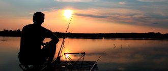
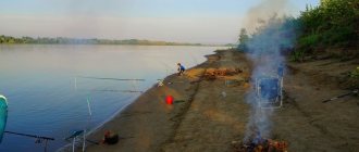
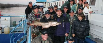
Cool summers and cold winters. This combination allowed the development of many resort and tourist areas on the lake. Mainly, sports tourism flourishes: fishing, hunting, berry and mushroom picking. In winter, travelers can go skiing or try other snow sports.
Wilderness mountain treks are open in the lake area. There are plenty of mountain routes for travelers.
Travelers often take rest on the various picturesque banks of the Imandra. This is a kind of ritual when traveling along the huge coastal area of the lake.
For adrenaline lovers, there are also extreme tourist destinations, such as boating of high difficulty categories. More relaxed travelers prefer relaxing boat rides in shallow currents.
Anthropogenic load on the lake:
On the shores of Lake Imandra, the largest plant for the extraction and processing of apatite deposits, copper-nickel smelting and iron ore production are located, a nuclear power plant was built on a direct-flow cooling system, and more than 300 thousand people live, which is almost 35% of the total number of residents of the Murmansk region. Federal railways and highways run along the shores of the lake. For more than half a century, the lake itself, reservoirs and watercourses in its catchment area have been used as a source of technical and drinking water supply, in the interests of recreation, tourism, and fishing. All this leads to a high anthropogenic load on the lake. Four time periods are identified with which anthropogenic modifications are associated:
- pre-industrial state corresponding to natural indicators (before 1940);
- the period of increasing anthropogenic load, when pollution began to prevail over the self-purification of water (1940-1970);
- maximum pollution, when degradation processes in the ecosystem reached their greatest development (1970-1990);
- the period of decreasing anthropogenic load, when trends towards improving water quality and ecosystem restoration emerged (1990-2000).
Among the main industries - sources of pollution of Lake Imandra, the following stand out: mining industry (JSC Apatit, the cities of Apatity and Kirovsk), metallurgical industry (Kola MMC, JSC Severonickel, Monchegorsk), iron ore production (JSC Olkon, Olenegorsk), energy complex (Kola Nuclear Power Plant, Apatitskaya Thermal Power Plant, Nivskye HPP cascade), as well as municipal wastewater of cities.
Literature
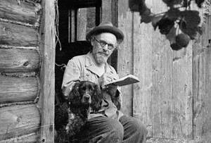
Interesting facts about Lake Imandra are associated with the travels through this magical land of the Russian writer Mikhail Prishvin, who was amazed by the beauty of his untouched native nature. The traveler's notes compiled a diary of wanderings across the expanses of Russia. A separate addition was the book “Behind the Magic Kolobok,” which reflected all the writer’s impressions of the most beautiful pearl of the Russian North, where he vividly describes the unique way of life of the Laplanders, admiring the originality and mystery of the descendants of the Kalevala heroes.
Flora and fauna:
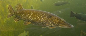
Fish appeared in the reservoirs of the European Arctic after the retreat of the last glacier, i.e. approximately 10 thousand years ago. Ichthyofauna of water bodies of the Kola North, including lake. Imandra is relatively poor in species. The fish part of the Imandra community is represented by four faunal complexes: boreal lowland - pike, perch, ruffe, ide, lake minnow; boreal-piedmont - grayling, brown trout; Ponto-Caspian freshwater - stickleback; Arctic freshwater - whitefish, loaches of the genus Salvelinus, smelt, burbot. Fishing here is especially interesting and productive in May. In terms of the number of species in the lake, fish of the boreal lowland complex dominate, but the main share of ichthyoproducts is made up of fish of the freshwater arctic complex. Fishing is a common activity in these places. In commercial catches their share sometimes reaches 90%.
And finally, the flora and fauna that developed on the borders of the tundra and forest zones. The forests of the Lake Imandra basin are home to many wild animals and birds, such as brown bear, reindeer, elk, wolverine, wolf, hare, marten, etc.