The Sylva River is a clean and high-water river flowing through the territories of two Ural regions - the Sverdlovsk region and the Perm region.
The name of the river comes from the Komi-Permyak words “syl” - melt, “va” - water (there are other rivers with a similar name in the Urals, for example, Sylvitsa - a tributary of the Chusovaya). It fully justifies its name. The water in the river is clean, soft and pleasant to the taste.
Sylva is good for transport accessibility, relatively clean water and the absence of any dangers for beginners and unprepared tourists. The disadvantages include a rather weak current, thickets of algae in the summer and a small number of rocks in the upper and middle reaches.
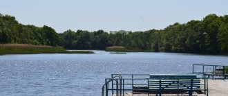
The length of the Sylva River is 493 kilometers. Starting in the Shalinsky district of the Sverdlovsk region (on the southern spurs of the Basque Ridge near the Vyrubki railway station), it ends in the Sylvensky Bay of the Kama Reservoir near Perm. Sylva is the largest tributary of the Chusovaya River.
The total catchment area of the river is 19,700 sq. km. The average slope of the river is 0.3 meters per 1 kilometer. Due to the small slope, the current speed is low (2.5-3 km/h). The bottom is mostly pebble. There are large islands.
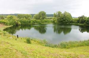
The largest tributaries of the Sylva: Vogulka, Irgina, Iren, Babka (left), Barda and Shakva (right). On some tributaries of the Sylva, near the mouth, old factory ponds have been preserved. There are oxbow lakes.
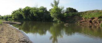
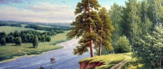
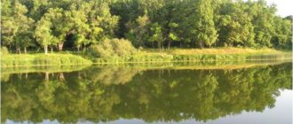
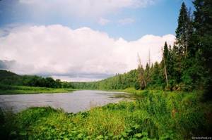
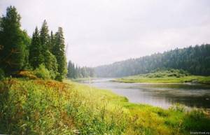
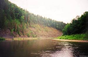
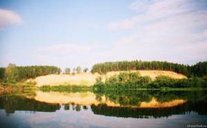
Along the banks of the Sylva there is a forest (mainly pine forests), alternating with glades and meadows. Previously, wood was floated down the river, so in some places (especially in the pools) driftwood can be found.
There are many settlements on Sylva. People have long noticed this river. There are many archaeological sites on the banks of the Sylva - ancient settlements and fortifications. Moreover, one of the archaeological cultures was called Sylven.
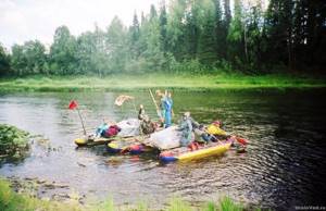
Rafting on Sylva
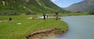
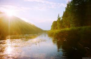
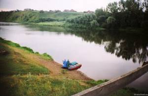
The river is popular among lovers of water tourism, especially in the section from Kisherti to Kungur (although it, of course, cannot compete in popularity with Chusovaya or Usva). Suitable for rafting throughout the entire season - from early May to September. Some tributaries of the Sylva are also suitable for rafting - the rivers Vogulka, Babka, Iren, Barda.
The length of the section of the Sylva River suitable for rafting is more than 300 kilometers.
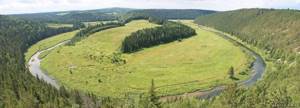
The river bed winds strongly, the intricate loops are clearly visible on the map. Lots of rolls. In the summer, there are often places on the reaches that are abundantly overgrown with algae, which greatly complicate rowing.
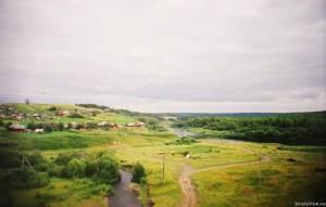
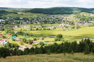
There are many settlements here. In villages and hamlets encountered along the way, you can replenish food supplies. Many villages remained only on old maps and no longer exist these days. You can talk about Sylven villages for a long time, but here I will write only about the most interesting.
In the lower part of the Sylva River (behind Kishertya), karst is highly developed; grottoes and caves are found in the coastal rocks. The most famous cave in the valley of the Sylva River is Kungurskaya. It is definitely worth a visit if you finish rafting in the city of Kungur.
Hydrology
- Water system: Chusovaya → Kama → Volga → Caspian Sea.
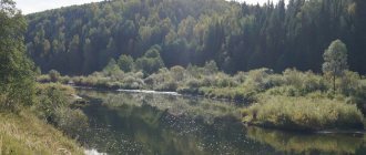
- The nature of the flow: in the upper reaches - foothills, in the middle and lower reaches - flat.
- Reservoirs: Permyakovsky pond, Sylvinsky reservoir, Sylvinsky pond.
- Bottom: mostly rocky and pebbly, there are also sandy and clayey places.
Village Sylva - Shamary (150 km)
The Sylva River is suitable for rafting starting from the village of Sylva near Shali (Sverdlovsk region). All passenger trains passing through Perm and Yekaterinburg stop at Chalet, and buses go to Sylva. In Sylva, an old church and some buildings of the old Sylva ironworks have been preserved.
You can start your journey along the river right behind the Lower Sylvensky Pond. The length of the Sylva – Shamary route is about 150 kilometers. The river here winds a lot.
Along the way you will meet Old Believer villages, which is rare for the modern Urals. Moreover, near the villages of Kedrovka and Simonyata there are several revered graves of Old Believer saints.
This section of the river is perhaps the least visited by tourists. Therefore, there are few good parking places. An obstacle when finding places to set up a camp are high banks. But the river here is the cleanest and crowds of tourists will not interfere with relaxation and enjoyment of nature.
In the village of Koptelo-Shamary there is a dangerous place - a structure made of logs and metal hidden in the water. Be careful not to tear the vessel.
The route can be completed at Shamary station, from where it is easy to travel to Perm or Yekaterinburg.
Geography
- Coastal landscape: the river flows through hilly terrain, among coniferous, mixed and deciduous forests. In some places it winds strongly, forming oxbow lakes. From time to time you come across sandstone and limestone rocky outcrops along the shores. Karst is developed in the lower reaches of the river.
- Settlements on the banks: Permyaki, Sylva, Shigaevo, Koptely, Teplyaki, Kedrovka, Simonyata, Roshcha, Niz, Platonovo, Koptelo-Shamary, Shamary, Nizhnyaya Baska, Kremlevo, Molebka, Krasny Lug, Berezovka, Agafonkovo, Tis, Ust-Irgino , Suksun, Ust-Kishert, Kungur
Source
- Coordinates: 57°14′15″ N. latitude, 59°03′05″ e. d.
- Altitude above sea level: 380 m.
- Topographical landmark: a spring in the vicinity of the village of Vyrubki.
Estuary
- Coordinates: 58°06′50″ N. latitude, 56°37′50″ e. d.
- Altitude above sea level: 108.2 m.
- Location: Chusovaya River - left bank 21 km from its mouth - within the boundaries of the village of Lyady.
Territorial location
- COUNTRY: RF . Region: Perm region . Districts: Kishertsky, Kungursky, Permsky, Suksunsky.
- District: Shalinsky.
Interactive map
Shamary – Spaso-Barda (210 km)
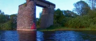
Shamar is easily accessible by train, both from Yekaterinburg and Perm. From the station you need to walk along the tracks for about a kilometer to the railway bridge over Sylva. There is a convenient place for assembling watercraft.
The long, several hundred kilometers stretch of the Sylva River from Shamar to Kungur can be divided into sections depending on the number of free days. You can raft to Suksun, Spaso-Barda, Ust-Kisherti, or to one of the many villages on the river (roads from the Perm-Ekaterinburg highway lead to them).
Rocks from Shamar to Spas-Barda are very rare. And those that come across are small and composed of sandstones and shales. But on the stones you can find fossils, imprints of ancient plants and insects.
Soon after tourists leave the Sverdlovsk region and enter the Perm region, rafters sail to the village of Molebka. Before the arrival of the Russians, this place was a place of worship for the Mansi, a sanctuary. This is where the name comes from. In the 18th century, an ironworks was built here, on the Molebka River. Now the only reminders of it are scattered slag, the remains of an old fire wall and the bed of a small pond.
Among the attractions, it is worth noting the old, abandoned church, monuments to an alien and an alien ship.
Since the late 1980s, this village of Molebka has been widely known in Russia and even in the world. Who hasn't been here? And all thanks to the anomalous zone discovered by the late Emil Bachurin and located south of the village.
When passing by it, it is worth making a stop in the “zone” and visiting its attractions: Central Glade, Vyselki, Glade of Horrors, etc. There are always a lot of people here in the summer, most of whom come here every year. They willingly share their observations of the unknown.
Further, on the southern border of the “zone” (the former village of Skopino is indicated on the maps in this place), the river passes between two hills: on the left bank there is Snake Hill with a rocky outcrop, and on the right bank there is Mount Pyramid. The place here is one of the most beautiful on this section of the river.

Near the village of Berezovka on the right bank there will be a rock approximately 3 kilometers long, which is called Konskaya Mane. It is a landscape natural monument. Below is another natural monument, this time a botanical one - the Tukmanovskaya larch grove. This is the southernmost larch grove in the Urals.
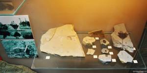
Below the villages of Agafonkovo and Tebyenaki the Chekarda River flows into the left. Here, on the left bank, the Chekarda section, widely known among scientists, is exposed - a geological natural monument.
On the shales in the section there are numerous imprints of ancient plants and insects. They are presented in many Ural and Russian museums. Scientists have discovered more than a hundred species of insects previously unknown to science in Chekarda! The age of these deposits is about 270 million years.
Further, in front of the village of Tis, is the southernmost point of the Sylva River. Here the previous general south-west direction changes to north-west. This place is called Turning Mountain.
It is worth noting that in the village of Tis in 1763, Grigory Demidov built a hammer factory. The factory is long gone, but the old factory pond has survived to this day.
Below, on the left bank, is the large, ancient village of Torgovishche. This settlement was first mentioned in documents from 1671. Here, on the old trade route, a fort with eight towers surrounded by a palisade was built in the 17th century. During the Peasant War, the fort was besieged and burned by one of the Pugachev detachments. Miraculously, only the Spasskaya Passage Tower survived. On the night of July 17, 1899, fire destroyed it too. But in 1905, the residents of Torgovishche built a copy of it on their own in another place, in the center of the village.
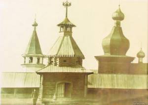
Museum workers noticed it, and in 1971 they transported it to the Khokhlovka architectural and ethnographic museum that was being created, located near Perm. This tower became the first object of the museum.
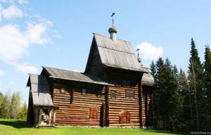
Currently, another interesting object of Russian wooden architecture has been preserved in Torgovishche - the wooden bell tower of the demolished Church of Zosima and Savvaty, built in 1715.
From Torgovishche you can take the road to the even more ancient village of Klyuchi on the Irgina River, located 7 kilometers from Sylva. This is what Academician I.I. wrote about him in 1772. Lepekhin:
“The village of Klyuchi is named after the many springs flowing from the ridge on which it is built. About 3 versts from the village there is a round and wooded ridge (Mount Gorodishche), from under which a rapid spring gushes out, carrying sulfuric matter with it. The sulfur from the rapid water makes a special foam, which sticks to the shores and adheres. It accumulates so much that all the residents of the vast village of Klyuchi and their neighbors use it in abundance.”
At the foot of Mount Gorodishche there is the Klyuchi resort (a health clinic on local waters appeared here back in 1826 thanks to the Suksun doctor A.P. Shcherbakov). Mount Gorodishche itself is also very interesting, standing out for its conical shape. The mountain got its name due to the ancient settlement located at the top. An earthen rampart still remains from it.
Upstream of the Irgina there is a beautiful, tall Vakutin (Grey) stone. Its 90-meter peak offers magnificent panoramas. Rare plants are found on the stone itself.
But let's return to the Sylva River. Immediately after Merchant, the river makes a 5-kilometer loop, and the distance along the isthmus is only 400 meters. At one of the bends of the loop on the left is the mouth of the Irgina River.
Below are several villages, the most interesting of which is the village of Tokhtarevo. Tokhtarevo has been mentioned in documents since 1645. But in the 1660s, misfortune befell him - the attacking Bashkirs burned him to the ground. In 1671, a monastery (New Mother of God Hermitage) was founded on this site, which existed until 1764. According to Orthodox legend, at the end of the 17th century, the Burning Bush icon sailed here along the Sylva River. The clergy took this as a sign from above and in subsequent centuries they revered this icon.
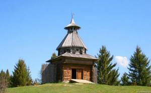
Like Torgovishche, Tokhtarevo was famous for its rare objects of Russian wooden architecture. In 1694, a wooden Church of the Virgin Mary was built here. In 1979, it was dismantled and transported to the Khokhlovka Architectural and Ethnographic Museum, and in the subsequent years 1980-81 it was erected and restored in a new location. The church stands in Khokhlovka on the top of a hill next to a tented bell tower brought from the village of Syra in the same Suksun region (located near the village of Tig).
Near Tokhtarevo is an ancient “Chudskoe” settlement.
In front of the village of Suksun on the Sylva in the 18th-19th centuries there was a Koshelevskaya pier and rafting site, where barges and kolomenkas were built, loaded with products and sent down the Sylva - to Perm and further along the Kama and Volga.
The village of Suksun is worth a visit. This is a large settlement with many interesting attractions.
The Suksun plant was built in 1727 by Akinfiy Demidov. Factory buildings, churches, old houses and parks have been preserved in Suksun from past centuries. The main architectural attraction was the estate of Kamensky, who bought the plant from the Demidovs after the abolition of serfdom. Unfortunately, in 2001 it was destroyed by fire.
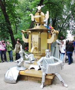
Suksun is considered the birthplace of samovars. A monument to the samovar was erected in the center of the village several years ago. Suksun was also famous for the production of melodious bells.
Other products were also manufactured. It is interesting that the copper quarter, made in 1748 by master Fyodor Kiselev at the Suksun plant, was used by the outstanding Russian scientist M.V. Lomonosov.
In 1841, the iron steamer Nikita Demidov was built at the Suksun plant, which safely transported cargo from the Suksun plant to Perm and back.
According to legend, a treasure is buried at the mouth of the Suksun River - a “golden” boat loaded with Ermak treasures.
Below Suksun (near the villages of Sasykovo and Pepelyshi) is one of the main attractions of the Sylva River - the Plakun waterfall. The sound of water falling from a 7-meter height can be heard from afar. It is worth not only admiring the waterfall, but also, having climbed, inspect the place where groundwater emerges from sandstone cracks. If you wish, you can stand under the stream of the waterfall. But I warn you: the water is icy!
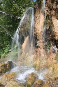
Near the waterfall, the river is crossed by a suspended pedestrian bridge.
Continuing the rafting, you will reach the village of Krasny Yar. Since the 18th century it has been known for its salt springs. For some time, the Krasnoyarsk salt plant of the Osokins, which had four breweries, even operated here. In the 1870s, local water was used for treatment by Suksun doctor A.P. Shcherbakov, already mentioned above.
Here, on the high right bank, is the Krasny Yar sanatorium, founded in 1932. In 2012, it was annexed to the already mentioned Klyuchi resort. The sanatorium uses local bromine chloride-calcium-sodium strong brine mineral waters with a high iodine content for treatment.
Until recently, a ferry service operated here; now a suspension bridge has been built.
Another interesting place is the village of Mazuevka, located near the Sylva River. In the first half of the 18th century, one of the first Ural factories operated here, on the Mazuevka River - first a copper smelter, then an ironworks. But he did not work for long. It is believed that due to the opposition of the powerful Demidov, the founder of the plant, Fyodor the Young, was shackled in 1713 and taken to Tobolsk.
Near the village there is the so-called Mazuevskaya karst depression. In the vicinity of the village of Mazuevka there are many karst sinkholes (in some of them lakes have formed), and there are caves. The most interesting place is the Volchya Yama failure (diameter 120 and depth up to 50 meters) with the Varsanofeva cave.
From the mouth of Mazuevka, along the left bank, the Cherny Yar cliff stretches for 1.5 kilometers, under which passes the highway connecting Mazuevka and Cherny Yar. Imprints of ancient plants are also found here.
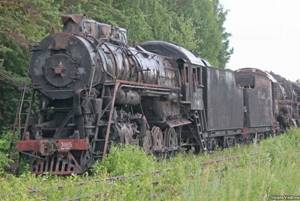
Just before the village of Spaso-Barda, on the right bank, there is the “Steam Locomotive Cemetery,” quite famous among urban trip lovers. Until recently, many rare steam locomotives and carriages from the 1930s-50s stood here for conservation. Some of it has survived to this day.
Next is the village of Spaso-Barda on the left bank of the Sylva. This is an old village founded in 1675. “Barda” is a river, a tributary of the Sylva, and the prefix “Spaso” arose from the Church of the Savior Not Made by Hands, the stone building of which still adorns the village (built in 1859).
At the railway bridge crossing the river it is convenient to finish the rafting and go by train to Perm or Yekaterinburg (via Shalya). It is less than a kilometer from the bridge to the Shkolnaya site.
From Shamar to Spaso-Barda along the river is 210 kilometers.
Tributaries
Main article: "Tributaries of the Sylva".
| Rights | Left | |
| SOURCE | ||
| Aleshin Log | 489 | |
| 484 | Bolshoi Kosogorny | |
| Vaska | 482 | |
| Sukhoi Vaska | 480 | |
| Kultysh | 478 | |
| Trash | 475 | |
| 470 | Sarga | |
| Steep | 465 | |
| 463 | Shawl | |
| Bolshaya Lomovka | 457 | |
| Lomovka | 455 | Varlashevka |
| Sosnovka | 450 | |
| Kopanets | 445 | |
| Mazanka | 437 | |
| Wild duck | 433 | |
| Lugovaya | 421 | |
| Izhbolda | 416 | |
| Big Bee | 387 | |
| Black | 383 | |
| 380 | Sharpening | |
| 379 | Eltsovka | |
| Kedrovka | 378 | |
| Chelpashek | 373 | |
| Talezhanka | 364 | |
| Urma | 362 | |
| Kamenka | ||
| Malaya Urma | 355 | |
| Borodinka | 354 | |
| Kureynaya | 350 | |
| Biz | 337 | |
| Duvanka | 328 | |
| 324 | Platonovka | |
| Big Hook | 314 | |
| 311 | Dmitrievka | |
| 309 | Dirty | |
| 304 | Shamarka | |
| Salty | 300 | |
| 295 | Big Kozyal | |
| old woman | 292 | |
| 290 | Vogulka | |
| Baskaya | 284 | |
| Vyazovochka | 276 | |
| 270 | Settlement | |
| 267 | Kuryl | |
| Black | ||
| Lipok | 263 | |
| Kamenka | 260 | |
| 254 | Kurya | |
| Molebka | 250 | |
| Ishimovka | 241 | |
| Bolshaya Kamenka | 234 | |
| 226 | Vyazovka | |
| 222 | White Mountain | |
| Bogodonovka | 220 | |
| Baybalda | 218 | |
| Red Meadow | 216 | |
| 208 | Studenyi Log | |
| 206 | Berezovka | |
| Syzganka | 191 | |
| 187 | Ut | |
| 184 | Berdykaevsky | |
| 182 | Checkarda | |
| Big River | 178 | |
| 174 | Baybalda | |
| 167 | Tisa | |
| 155 | Irgina | |
| Yurkan | 147 | |
| 140 | Shatlyk | |
| 134 | Sandushka | |
| Istekaeva | 128 | |
| Yusupovka | 120 | |
| Mechinka | 118 | |
| 108 | Mazuevka | |
| 94 | Karabarakin | |
| 91 | Chubykchovsky | |
| Lek | 89 | |
| Barda | 83 | |
| Pelvis | 73 | |
| 61 | Kishert | |
| Shakwa | 26 | Iren |
| 21 | Grandma | |
| Mechka | 122* | |
| 105* | Malaya Yakshovka | |
| 88* | Vaskin | |
| 87* | Levshina | |
| 85* | wild | |
| Serga | 78* | |
| 60* | Cheese | |
| Nozzle | 51* | |
| 30* | Bykovka | |
| 28* | Bolshaya Voronovka | |
| 27* | Pavement | |
| Yurman | 23* | |
| Kutamysh | 22* | |
| Denisovka | 18* | |
| Half | 15* | |
| Bykovka | 11* | |
| 2* | Lyadovka | |
| MOUTH | ||
Scheme 1. Tributaries of the Sylva. The numbers indicate the distance (in kilometers) from the place where the Kama Reservoir begins (Sylva Bay), the numbers with asterisks indicate the geographical mouth of the Sylva.
Spaso-Barda - Kungur (70 km)
Here, in Spaso-Bard, you can start rafting along a picturesque stretch of the river to Kungur (the length of the route is 70 kilometers). Rocks made of limestone, familiar to Ural tourists, begin to appear here.
Below the railway bridge, the Sylva receives a large right tributary - the Barda River, which is also suitable for rafting.
Further on the right bank there is a rocky outcrop of Kamennaya Sluda stretching for one and a half hundred meters, the height of which is up to 8 meters. The village of Morozkovo is located on it.
Below the village of Sukhoi Log, behind a sharp bend in the river bend on the right bank, the Lobach stone, 40 meters high, will appear - one of the most beautiful and interesting Sylven rocks.
At the top of Lobach you can not only admire the view, but also find the rampart of an ancient settlement. Here is what the News of the Society of Archeology, History and Ethnography at Kazan University wrote about him in 1884:
“...One of these settlements is located on the right bank of the Sylva, near the settlement of Kisherti, 30 versts from the city of Kungur up the river, and is located on top of the pointed large stone Lobacha, rising in the form of an isolated rock 20 fathoms above the river level. The flat top of this stone can only be reached from the shore, which is connected to the top of the peak by a narrow isthmus. The stone is completely inaccessible from the river. The upper platform of Lobach is separated from the isthmus by a ditch and a rampart that has crumbled considerably...”
Behind the village of Posad, on the low left bank, is the largest lake in the Sylva River valley - Lopaevo. In shape it looks like a large horseshoe with a length of more than 3 kilometers. The lake is of oxbow origin. At the bottom of the lake there is healing sapropel.
Further on the right bank is Mount Maple, composed of corals.
Downstream will be the village of Ust-Kishert, the regional center. If you wish, you can start rafting to Kungur from here, and not from Spaso-Barda. After Ust-Kisherti, Sylva has the most tourists, especially on weekends. This rafting section is good because it can be easily covered in two days.
The village of Ust-Kishert (or simply Kishert) is known for its karst sinkholes right within the village. In many of which lakes have formed. Some lakes of failed origin completely unexpectedly formed right in the gardens of villagers. For example, Lake Eight, which appeared in 1949.
But the most famous lake-sink of Kisherti is Molebnoe. According to legend, this failure was formed two centuries ago right on the site of a church, which sank to the bottom of the resulting lake. A sort of Kitezh-grad in the Ural style. It is not surprising that for a long time religious ceremonies were held on the shores of this lake. The depth of the lake reaches 19 meters; tree trunks lie at its bottom.
Another - the largest lake - Kisherti - Kisloye is notable for its healing mud, which was used in treatment during the Great Patriotic War. There are many other lakes in the vicinity of the village.
Another interesting natural phenomenon in Kisherti is the so-called heaving mounds (or burial mounds). They have a curious feature - as frost sets in, their height increases and decreases in summer.
Continuing the rafting, tourists soon find themselves in the territory of the Preduralye nature reserve.
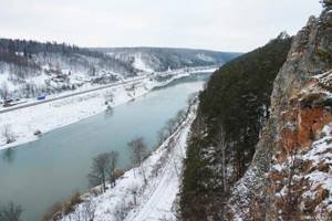
Below, Sylva makes a large 7-kilometer loop, skirting Mount Lopata. From here there are numerous rocks: the Robber (Khorobriy), Vostry (Zub), Glazyr stones on the right bank, Crown, White Stone, Kamaiskie Zubtsy on the left and others. The height of the peaks reaches 90 meters above the river's edge. Due to the steepness of the Sylven banks, climbing the rocks is not easy.
From here all the way to Kungur, the Yekaterinburg-Perm railway runs along the left bank, enclosed in a gorge cut by the Sylva River.
Below (on the right bank) are the most famous and popular rocks of the Sylva River - the Mezhevoy and Ermak stones. Every weekend numerous tourists come here, mountaineering trainings and competitions, and tourist rallies take place.
It’s definitely worth stopping here and climbing to the top. The Ermak stone has three peaks: Ermak, Ermachikha and Ermachenok. According to legend, Ermak’s army reached these places, allegedly confusing Sylva with Chusova. However, there is no scientific evidence for this.
There is a small cave in the Mezhevoy stone. In addition, rare plants grow on these rocks. There are fossils on the rocks.
Further on the left bank there will be the Uncle stone, and on the right, in front of the village of Filippovka, there is a large quarry, which will be interesting for geology lovers to look into.
Rafting on the Sylva River ends either in the village of Filippovka in front of Kungur, or in the city of Kungur itself.
Here it is worth visiting the Kungur Ice Cave (entrance to the cave is paid, it is not cheap), see the karst sinkholes on Ice Mountain and Ermakovo ancient settlement.
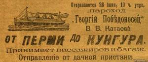
If possible, wander around the oldest merchant city of Kungur, which has a lot of interesting things. In Kungur you can take a train or bus and return home. Interestingly, a passenger ship used to travel between Kungur and Perm. Now you can only remember this by looking through old advertisements.
Some swim further along the river - to the village of Serga. This makes sense, since it is below Kungur on Sylva that there is the maximum number of rocks, numerous caves (Babinogorskaya, Novopodkamenskaya, Bolshaya Mechkinskaya, Kichmenskaya, Oktyabrskaya, Zuyatskaya, Andronovsky Grotto and many others) and several famous archaeological sites...
Fishing on Sylva
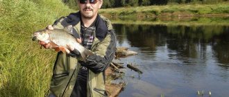
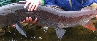
Sylva should also appeal to fishing enthusiasts. Here you can catch roach, chebak, gudgeon, chub, bream, ide, perch, ruffe, pike, burbot. In some places on the Sylva and its tributaries you can find “Ural trout” - grayling, which loves clean water. According to some reports, asp and pike perch are occasionally found. Although you shouldn’t expect much from fishing on Sylva.
© Pavel Raspopov
UraloVed.ru
See also:
- Bioherms of Permian age on the Sylva River
- The village of Sylva and Sylva pond
- State Emergency Committee on Sylva