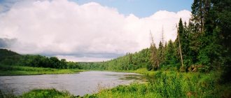
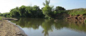
For the first time, the Volkhov River, flowing through the modern Novgorod and Leningrad regions, was mentioned in chronicles of the 11th century. The river is a witness to many historical events. On its picturesque shores lie cities with ancient Russian original architecture. The flow of tourists to these places does not stop: people come here to admire the Volkhov open spaces and become familiar with the history of the great country.
Etymology
There are different versions of the origin of the name of the river.
The most poetic explanation is presented in the 17th century legend “The Tale of Sloven...”. In ancient times, Prince Sloven came to Lake Ilmen and founded the city of Slovensk (Veliky Novgorod). He named the river on which the city was built Volkhov in honor of his eldest son.
According to another version, the river received its name in honor of Volkh, the god of hunting among the ancient Slavs.
Some associate the origin of the name with pagan priests - magi, who performed rituals on its banks.
There is also a more ordinary explanation. Alder once grew in abundance in the floodplain of the reservoir. She gave the name to the river. It is believed that “Volkhov” is a derivative of the name of the tree.
The etymological dictionary of M. Vasmer refers us to the research of the famous linguist, Slavist - I.Yu. Mikkola, who claims that the name comes from the Finnish language.
general characteristics
The rivers of the Novgorod, Pskov, Tver and Leningrad regions carry water to the Volkhov. The territory of its basin is 80,200 km², with more than half of the area (61%) belonging to the Novgorod region. The length of the river is 224 km. When the Volkhov flows from Ilmen, its width is no more than 220 m. Downstream the channel widens to 350 m. The depth of the Volkhov River increases towards Lake Ladoga. Average depths reach 4–5 m, maximum depths – 15 m.
Volkhov is a typically flat river. The height difference between the source and the mouth is 13 m, which corresponds to an average slope of 0.06%. In the section from the source to the Pchevsky rapids, the slope is less - 0.007%, which is why it flows here more slowly, at a speed of 1 m/s.
Volkhov River
The Volkhov River is located in North-West Russia. The Volkhov flows from Lake Ilmen and flows into Lake Ladoga. The length of the river is 224 kilometers. The width of the river near Novgorod is 220 meters, the maximum depth is 12 meters, the average depth is 4 - 5 meters.
The main tributaries of the river are Oskuya, Pchevzha; Kerest, Vishera, Tigoda. On the Volkhov River there are cities - Novgorod, Kirishi, Volkhov, Novaya Ladoga. The river is navigable along its entire length. The Volkhov hydroelectric power station was built on the river. On the river, you can sometimes observe a phenomenon when the direction of the water flow changes its direction and the river flows not towards Lake Ladoga, but towards Lake Ilmen. This is possible due to the small elevation difference between the source and the mouth of the Volkhov. When the water level in the lake is low and due to the backwater of water from the tributaries, the Volkhov current can change direction.
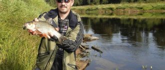
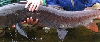
The river is famous for its fishing routes. You can catch fish everywhere, but the most popular places among anglers are the mouths of the Pchevzha, Tigoda, Oskuya and Keresti rivers. Volkhov is inhabited by: pike, pike perch, asp, catfish, burbot, bream, bluefish, whitefish, silver bream, perch, loach, ide, roach, sabrefish, ruffe, bleak.
Volkhov is famous for the legend that a monster lives in the waters of the river - the “korkodel”. The most ancient mentions date back to the 9th century. One of the most recent is a video of a large unknown animal swimming under a pedestrian bridge. The video was shot by Alexey Morozov in 2007. Experts say it could have been a swimming seal with two babies. You shouldn’t exclude catfish either. Catfish can reach enormous sizes, but the Volkhov River is not famous for its record numbers of these fish.
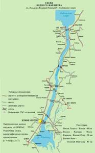
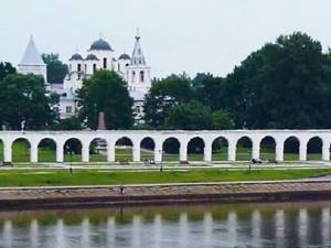
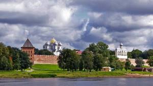
River cruise routes run along the Volkhov River, the end point being Veliky Novgorod. Veliky Novgorod is one of the oldest cities in Russia, located at the source of the Volkhov River and Lake Ilmen. Its history is inextricably linked with all the most important stages in the life of the Russian state. Twice in the middle of the 9th century and at the end of the 15th century it stood at the cradle of Russian and Russian statehood. The Novgorod Kremlin (Detinets) stands on a hill located above the Volkhov level at an altitude of 10 meters. It has the shape of an irregular oval, elongated from south to north and somewhat concave on the coastal side. The outer perimeter of its walls is 1487 meters. Detinets is the citadel of Veliky Novgorod, located on the left bank of the Volkhov River. The walls are built of stone and brick with lime mortar. The stonework consists of limestone and cobblestones. The thickness of the fortress walls varies in different parts - from 3.6 to 6.5 m. The height ranges from 8 to 15 m.
Features of the flow
Ancient chronicles mention that the river sometimes moves “at the head,” that is, backwards. The fact is that in the upper reaches the slope of the river is insignificant, and when the water level in the Ilmen drops, the Volkhov and its upper tributaries rush back to the source. The last time a similar phenomenon was observed was in 2013, when Volkhov stopped.
Interesting fact. The peculiarity of the river flowing backward is connected with the legend about how “Vladyka John flew on a demon.” In the 12th century, Novgorodians suspected Archbishop John of sinfulness and decided to expel him from the city. They tied the clergyman to a raft and sent him down the Volkhov. But the raft, contrary to expectations, floated against the Yuriev Monastery. The amazed townspeople saw this as a sign from above, persuaded the bishop to return, and erected a stone cross on the shore.
Historical information
Folk etymology from the 17th century book legend “The Legend of Sloven and Rus and the city of Slovensk” connects the name of the river with the name of Sloven’s eldest son, Volkhv (Volkhov).
I. Yu. Mikkola derives the name of the river from the Finnish. Olhava, given the Swedish. Ålhava in the 16th century and Finnish letters. Olhavanjoki.
About 2000 years ago, the water level in Volkhov dropped below 10 meters in absolute height. The territory of the future Staraya Ladoga became suitable for settlement after a further decrease in the water level no earlier than the middle of the 1st millennium.
Under the Zemlyanoy settlement of Staraya Ladoga, plowing of the surface was carried out at excavation site 4 no later than or slightly earlier than the 6th century, and at excavation site 3 - starting from the second half of the 7th century - the first half of the 8th century. The agriculture of the first Ladoga residents is confirmed by finds of grains of wheat, rye, barley, millet and hemp. The rudimentary Slavic settlement could have arisen on Zemlyanoy fortification around 700 or even earlier.
On the site of the former mouth of the Volkhov River on the hill of the right bank in the 8th-9th centuries there was a Slavic Lyubshan settlement, opposite which Staraya Ladoga was built by the Varangians on the left bank. The Lyubsha fortress was founded by representatives of the original Slavic culture of Central European origin. On the left bank of the Volkhov River, near the village of Gorodishche Pchevskogo s/s, on a low cape, there was the ancient settlement “Gorodishche” - one of the chronicle “hails” of the Novgorod Slovenes; on the outskirts of the city of Volkhov there is the ancient settlement of New Duboviki. By the 9th-10th centuries, the Slavic population had already densely developed the upper reaches of the Volkhov. Here, in addition to the burial mounds, there was their central pagan temple in the Peryn tract, as well as two settlements: the Rurik settlement and the Kholopiy town.
Volkhov is also known as part of the “Road from the Varangians to the Greeks”.
The chronicle repeatedly pointed out that the Volkhov could flow “to the brim,” that is, in reverse. In particular, this happened in 1176:
In the summer of 6684. Ida Valkhovo was again on duty for 5 days.
The phenomenon is associated with the backing of the Volkhov Current by the waters of tributaries at a low water level in Ilmen. It can happen even today - in April 2013, the river’s movement stopped.
Food, freeze-up, ice drift, flood
The Volkhov is fed by melting snow, and in summer and autumn the water level is maintained by rain.
By mid-November, thin ice forms on the surface of the river. A strong ice cover is established by December, and by the end of February its thickness reaches 70–80 cm. An amazing natural phenomenon is associated with the freeze-up period, which occurs only on northern rivers. For the first time on the Volkhov, scientists discovered and described pyatras - ice formations shaped like mushrooms that attach to the bottom of the riverbed.
The river opens in April and is free of ice in 10-20 days.
The annual flow of Volkhov is 593 m³/s, according to some sources – 586 m³/s. Up to 70% of the runoff occurs during spring floods. During this period, the water level in the riverbed rises to 3 m, and in some years to 6-7 m. The river overflows its banks and floods nearby settlements.
Geographical information
The Volkhov flows through the Ilmen lowland and flows into Lake Ladoga. The length of the river is 224 km. The area of the Volkhov drainage basin is 80,200 km², of which 61% belongs to the Novgorod region, 21% lies within the Pskov region, 10% to the Tver region and 8% to the Leningrad region. The average annual water flow is 593 m³/s (according to some sources, 586 m³/s). Freeze-up from late November to early April. Navigable.
North of the Rurik Settlement, 2 km from Lake Ilmen, the right branch of the Small Volkhovets separates from the main channel of the Volkhov, which again flows into the Volkhov in the area of the Kholopye town, forming a large island on which the Trade side of Veliky Novgorod is located. The modern beginning of Maly Volkhovets was previously the Zhilotug stream, which had a small channel into Volkhovets. Previously, the source of Maly Volkhovets was located somewhat to the south, near the point where the Siversov Canal begins. Main tributaries: on the right - Vishera, Pchevzha, Oskuya; on the left - Kerest, Tigoda.
On the Volkhov are located (downstream): the city of Veliky Novgorod, the Krechevitsy microdistrict, the urban village of Krasnofarforny, the city of Kirishi, the city of Volkhov, the village of Staraya Ladoga, the city of Novaya Ladoga. The Volkhov hydroelectric power station was built on the river (Leningrad region).
Ecological state
The degree of pollution of the waters of the Volkhov, as well as the waters of other reservoirs, is determined using the UICZV - a specific combinatorial level of water pollution, which takes into account the general degree of pollution of the reservoir with various substances.
Volkhov's ICZV is 2.7, which corresponds to the “polluted” characteristic. Organic substances, petroleum products, and heavy metals were found in the water. Wastewater is discharged into the river by enterprises along its banks: the Kirishi Oil Refinery (Kirishnefteorgsintezgaz), CJSC Metakhim, an enterprise of the PhosAgro group and other industrial facilities.
Tributaries
The Volkhov has 30 tributaries.
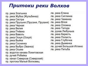
The main right tributaries are the Vishera, Pchevzha, Oskuya; left - Kerest, Tigoda, Olomna.
The length of Vishera is 64 km. The tributary flows into the Maly Volkhovets - the right branch of the Volkhov. The river is fed by peat bogs, so the water is bright brown.
Pchevzha carries water throughout the Novgorod and Leningrad regions. The length of the channel is 157 km. The width is up to 30 m. In the upper reaches the river is winding and narrow, and in the lower reaches it is deep and calm. Popular among rafting enthusiasts.
Oskuja is navigable. The length of the river is 114 km. Thanks to this river, the word “ushkuiniki” appeared, which in the distant past called Novgorod river robbers. They built their ships at the mouth of the Oskuya near Novgorod, and in the Novgorod dialect the name of the river sounded like Ushkuya.
Kerest flows from the swamps and flows into the Volkhov in the Chudovsky district. Its length is 100 km, its catchment area is 933 km².
Tigoda originates from the Tushinsky moss swamp. Length – 143 km, drainage area – 2290 km².
The Olomna flows through the Leningrad region. The length of the river is 52 km, the basin area is 420 km².
Volkhov River 5.0/5 rating 1 vote
Volkhov is the largest river in the Novgorod and Leningrad regions. The only river flowing from Lake Ilmen. The Volkhov River flows through the Ilmenskaya Lowland and flows into Lake Ladoga in the Volkhov Bay area.
Length 224 km, basin area 80.2 thousand km². The river bed has a uniform width - 200-250 m. The river bed is characterized by a lack of tortuosity. The river is navigable. Freeze-up is unstable. It freezes from the end of November, unstable ice remains on the river until the beginning of April. The average duration of ice drift is about 3-7 days.
Geography: The river begins to flow from Lake Ilmen near the village of Yuryevo, Novgorod district, Novgorod region. Further it flows through the Chudovsky district. After the village of Lezno, the Volkhov flows through the Leningrad region of the Kirishi district, divides the city of Volkhov into 1st and 2nd and near the city of Novaya Ladoga, Volkhov district, flows into Lake Ladoga.
Tributaries: The main tributaries of the Volkhov River: from the left - Kerest, Tigoda; on the right - Oskuya, Pchevzha. The largest right tributaries: Vavol, Velya, Vishera, Vybro, Vyyka, Gorodena, Derevyanka, Donets, Zhubka, Zlatynka, Maly Volkhovets, Oskuya, Osma, Prusynya, Pchevzha, Sosninka. The largest left tributaries: Vloya, Gzen, Glubochka, Dymenka, Elena, Kerest, Olomna, Pitba, Polist, Posolka, Prost, Robeyka, Siglinka, Tigoda, Chazhenka.
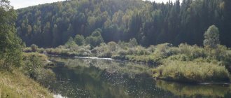
The river is characterized by birch and aspen forests. Pine forests grow at the mouth. Closer to the mouth there are forests in swamps.
Interesting: The river has a unique feature: the Volkhov can flow backwards. In particular, this happened in 1176. This is possible due to the small elevation difference between the source and the mouth of the Volkhov. When the water level in the lake is low and due to the backwater of water from the tributaries, the Volkhov current can change direction.
Fishing on the Volkhov: The river is famous for fishing. Among the fish species found in the river are: loach, white-eye, silver bream, asp, ruffe, crucian carp, bream, rudd, tench, perch, burbot, bluegill, roach, pike perch, bleak, catfish, pike. Fish can be caught everywhere; popular places among anglers include the mouths of the Pchevzha, Tigoda, Oskuya and Keresti rivers.
The most catchy places are the mouths of the Oskuya, Keresti, Tigoda and Pchvzhi rivers flowing into the Volkhov. In Volkhov there are fish common to European rivers: carp, pike, eel, smelt, catfish, pike perch, salmon, roach, bream, perch. The fish are great to catch in the current. Popular winter fishing can be unsafe - warm springs form invisible ice holes. The best places for winter fishing are Krinitsy and Dubno. The best place for summer fishing is considered to be the section of the river near the Volkhov-Most station. You can fish with a bottom fishing rod from a dry bank or boat.
The Volkhov River is also known as part of the “Road from the Varangians to the Greeks.” The Volkhov hydroelectric power station and the famous Staraya Ladoga fortress were built on the river.
Largest settlements
People have settled on the banks of the Volkhov since ancient times, starting in 700. Let's look at the most famous settlements.
Veliky Novgorod (until 1999 – Novgorod)
– the oldest city in Russia with a rich cultural and historical heritage. Here, from 1136 to 1478, the first free republic existed in feudal Rus'.
The village of Krasnofarforny (formerly the village of Botanovka)
located 83 km from Veliky Novgorod. In 1898, Ivan Kuznetsov built the Georgian Porcelain Factory nearby. Thanks to the development of the porcelain business, the village received its name in 1919.
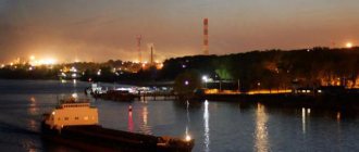
Kirishi city
first mentioned in 1693 as a village. The basis of its economy is the petrochemical industry. In the 1990s. Kirishi became known for the environmental movement against harmful emissions from the biochemical plant. The events were reflected in the documentary film “Us”.
Volkhov city
has an interesting history of origin, and it is connected with the quiet village of Zvanka, located on the banks of the Volkhov. At the beginning of the 20th century, the Obukhovo-Vologda railway passed through the village, Zvanka turned into a railway station and began to develop rapidly. In the 20s last century, a workers’ settlement arose near the station in connection with the construction of the Volkhov hydroelectric power station. In 1933, the construction workers’ settlement was merged with Zvanka and other settlements, and thus the city of Volkhovstroy appeared. Since 1940 it has been named Volkhov.
Village Staraya Ladoga
has an ancient history. The fact that people lived in these places for a very long time is confirmed by archaeological finds. In 2015, a site of an ancient man from the Neolithic era (3rd millennium BC) was discovered near Staraya Ladoga.
The Novgorod Chronicle claims that Ladoga is the first capital of Rus', because the Varangian Rurik (862–864) was called here to reign. They say that here is the grave of Prophetic Oleg.
Ladoga had an advantageous geographical position; it was located on the route “from the Varangians to the Greeks.” During the times of Novgorod Rus, the Staraya Ladoga Fortress was a kind of border point where sea vessels that were unable to overcome the rapids of the Volkhov stopped.
City of Novaya Ladoga
owes its origin to Peter I. In the XIV–XV centuries. On this site stood the Nikolo-Medvedsky Monastery. By order of Peter I, a shipyard was founded next to it, and in 1704 the city of Novaya Ladoga was founded.
Shipping: yesterday and today
Volkhov is a navigable river along which dry cargo ships, boats, and pleasure boats move. The navigation period is 190 days.
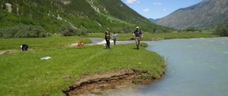
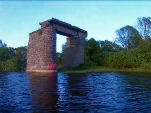
Volkhov was part of the ancient trade route “from the Varangians to the Greeks” that went from the Baltic Sea to the Black Sea. Foreign merchants moved from the Neva to Lake Ladoga and back along the Volkhov. In the lower reaches of the river it was necessary to overcome the Pchevsky rapids near the village of Gorodishche, 8 km long, and the Gostinopolsky (Volkhovsky) rapids near the village of Novye Duboviki. The Volkhovsky ones were more dangerous: their length was 9.5 km, and the water drop was 10 m.
To overcome difficult areas, shipowners had to hire pilots - residents of villages located from Gostinopol to Duboviki. Back in 1269, the treaty of Novgorod with the Hanseatic League of Lübeck and Gotland mentions empty ships - Vorsch-Kerle, who were supposed to accompany the Hanseatic merchants along the river. Pilotage provided local residents with income.
In Ladoga, goods were loaded onto flat-bottomed ships. People landed at the rapids, and ships were pulled on ropes through dangerous areas.
During the time of Peter I, shipyards were founded at the mouths of the Syas and Volkhov rivers and the first ships were built. The Tsar ordered the construction of a canal from Volkhov to the Neva - now the ships, bypassing the troubled Lake Ladoga, reached the capital.
At the beginning of the 19th century, the first steamships appeared on the Volkhov. They served the construction of military settlements in the Novgorod province.
In 1857, the Volkhov Shipping Company was established, which owned passenger and cargo ships.
Until 1924, coastal communication was carried out by 5 steamship lines.
The seventies were the heyday of shipping on the Volkhov. Freight, fishing and passenger transport moved along the river. Residents of Novgorod purchased motor boats and boats.
Transportation volumes declined sharply in the 90s, and they have not yet been restored to their previous volumes.
Volkhov
V o lkhov is a river in the north-west of the European part of Russia, in the Novgorod and Leningrad regions.
The name of the river supposedly comes from the Slavic “Olkhovaya”. According to another version, the river is named after the eldest son of the Scythian prince Sloven.
The original inhabitants of the river basin. The Volkhov were Finno-Ugric tribes. In the VI century. Tribes of the Krivichi Slavs settled here, in the 8th century. - Slovenian tribe. The river was part of the ancient trade water route “from the Varangians to the Greeks,” which went from the Baltic Sea to the Black Sea. Novgorod has been mentioned in chronicles since 859 precisely in connection with the trade route. Since the founding of St. Petersburg, the river's importance as a waterway has only increased. At the beginning of the 18th century. A shipbuilding shipyard was founded at the mouth of the river, which gave rise to the city of Novaya Ladoga. The city of Volkhov appeared on the river after the construction of the Volkhov hydroelectric station in 1926 and its opening in the 1930s. aluminum plant.
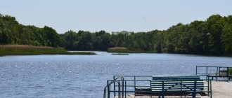
The river connects two lakes: it flows out of the lake. Ilmen flows along the Volkhov-Ilmen lowland and flows into Lake Ladoga. The length of the river is 224 km, the total fall (from source to mouth) is 13 m. The basin area, including the lake’s catchment area. Ilmen, – 80.2 thousand km2. Volkhov is the 2nd longest (after Syasi) and 2nd largest basin area (after Svir) river in the catchment area of Lake Ladoga. About 60% of the basin area is occupied by forests, 10% by swamps and wetlands. Lake Ilmen, from which the river flows, receives a number of large tributaries: the Msta, Lovat, Pola and Shelon rivers. The main tributaries of the river Volkhov: Vishera (right) and Tigoda (left). 3 km from the source near the village. The Sivers Canal, built at the beginning of the 19th century, begins on the right bank of the settlement. and connecting the Volkhov and Msta rivers. For the first 20 km, the river flows in two branches: the river itself. Volkhov and the Maly Volkhovets channel. In the middle reaches of the river. The Volkhov crosses an ancient lake basin of a glacial reservoir, the channel is incised, straight, up to 200–300 m wide and 10–12 m deep. The floodplain is clayey, swampy with channels and lakes in low banks up to 18 km wide. Below the hydroelectric power station Volkhov crosses the ledge of the Silurian plateau, forming several incised bends. 1 km from the mouth, the channel widens to 400 m. Three canals have been dug in the lower reaches of the river: the Staraya Ladoga (early 18th century) and Novoladozhsky (mid-19th century) canals connect the Volkhov and Neva; The Syassky Canal, built at the beginning of the 19th century, connects Volkhov and Syas. The canals were built to bypass Lake Ladoga, which is often subject to storms that complicate navigation conditions. The Novoladozhsky Canal is currently open to small vessels.
The water regime of the river is characterized by high spring floods. During the spring period, half of the annual flow occurs. The decline in flood water continues until October. In November and December, autumn-winter floods are observed. The average long-term water flow at the mouth is 590 m3/s (flow volume 18.621 km3/year). The maximum and minimum expenses for the village. Gostinopole - 2530 and 40 m3/s, respectively.
Due to the low flow speeds, the freezing conditions of the river almost throughout its entire length are close to those of lakes. Freeze-up on the river occurs in mid-November, the ice thickness reaches 0.8 m, and in April the river is cleared of ice. In some areas, ice cover is not established at all. Hydrologist Evfimy Ivanovich Ioganson on the Volkhov (in the area of the Gostinopol rapids) was the first to describe such an ice phenomenon as pyatry.
The river is home to pike, pike perch, bream and perch, and at the mouth there is lake-river whitefish, listed in the Red Book of Russia. River water is used for water supply and hydropower. Volkhov is navigable along its entire length.
Along the banks of the river are the cities of Veliky Novgorod, Kirishi, Volkhov and Novaya Ladoga. In the area of Kirishi, due to the discharge of industrial wastewater, water is regularly classified as polluted.
S.A. Agafonova, E.N. Antokhina, V.A. Bug
Volkhovskaya HPP
The Volkhov hydroelectric power station was built in 1916–1926. last century. The project belongs to the Russian engineer G. O. Graftio and dates back to 1902. It took 13 long years to improve the project to use the Volkhov to generate electricity. In 1916, construction began on a station on the Peter and Paul Rapids to supply power to the St. Petersburg railway junction. In 1921, the construction was included in the GOERLO plan. The initial capacity of the power plant was 58 MW, which later increased to 86 MW.
For the needs of the hydroelectric power station, the Volkhov reservoir with a volume of 24.36 million m³ was built. The area of the mirror is 2.03 km². The artificial reservoir is formed by a dam 450 m long.
The construction of a hydroelectric power station solved the problem of the Volkhov rapids: they disappeared under water after the construction of the dam. However, this led to a decrease in the population of the famous Volkhov whitefish. The fish, which went to spawn from Lake Ladoga to Ilmen, were unable to overcome the dam. The fish passage structure was poorly designed.
Interesting fact. In 1942, a 23 km long cable was laid along the bottom of Lake Ladoga to besieged Leningrad, and on the morning of September 23, electricity was supplied to the city from the Volkhov hydroelectric station. This operation was called “Breakthrough of the energy blockade of Leningrad.”
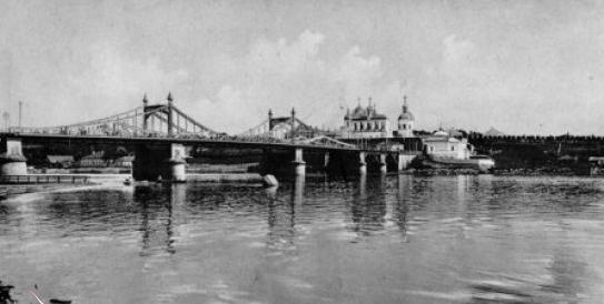
Bridges
The banks of the Volkhov are connected by numerous crossings.
There are 11 road bridges across the river:
- in Veliky Novgorod (named after Alexander Nevsky, Kolmovsky and Derevyanitsky);
- in the village of Kotovitsy;
- near the village of Sitno;
- near the village of Selishchi;
- between the village of Krasnofarforny and the village. Georgian;
- in Kirishi;
- in Volkhov (Ilyinsky and the bridge between the Simankovo and Plekhanovo microdistricts);
- on the M18 road to the village of Issad.
Railway bridges were built:
- near Volkhov Bridge;
- between railway station Volkhov-Pristan and the city of Kirishi;
- between railway station Thresholds and Kukol;
- between railway station Volkhovstroy-1 and Volkhovstroy-2.
In ancient times, the Great Bridge was built across the Volkhov in Novgorod, on which city residents resolved disputes that arose between them, proving their case in a fist fight. This bridge has not survived to this day; a modern pedestrian bridge was built in its place.
In addition, the banks are connected by a four-span pipeline bridge in Kirishi and the Volkhov hydroelectric power station dam.
Crossings across the Volkhov[ | ]
Velikiy Novgorod:
- Great Bridge[14][15] (historical) - does not exist
- During the siege of Novgorod in 1477-1478, the headquarters of Ivan III was located in Gorodishche, the prince ordered the architect Aristotle Fioravanti to build a bridge across the Volkhov from Gorodishche to the Yuriev Monastery on ships[16].
- Pedestrian bridge
- Bridge named after Alexander Nevsky
- Kolmovsky Bridge
- Derevyanitsky Bridge
From Novgorod to Chudov:
- Road bridge on the M10 road in the village of Kotovitsy (bypass of Veliky Novgorod),
- Road bridge on the M11 road in the village of Sitno,
- Road bridge on the P53 road between the villages of Selishchi and Spasskaya Polist,
- Double-track railway bridge on the St. Petersburg-Moscow railway (Volkhov Bridge).
From Chudov to Kirishi:
- Road bridge on the P36 road between the village of Krasnofarforny (towards Chudovo) and Gruzino,
Kirishi:
- Two-lane five-span road bridge,
- Single-track, four-span metal railway bridge between Volkhov Pristan and Kirishi station on the St. Petersburg - Pestovo - Moscow railway line,
- Four-span bridge-pipeline,
From Kirishi to Volkhov
- Railway bridge on the section between the 6 km checkpoint and Kukol station
Volkhov:
- Volkhov hydroelectric power station dam,
- Railway bridge on the section between Volkhovstroy II and Volkhovstroy-1 stations,
- road bridge,
- Road bridge.
Below Volkhov:
- Road bridge between Simankov and Plekhanov,
- Road bridge on the M18 road.
Flora and fauna
Coniferous trees grow in the river basin: spruce, pine, larch. Birch, aspen, and alder appear in cleared areas and fires. In some places there are oak forests, and in the flooded meadows there are willows.
In the floodplain, areas of forest are cleared and the land is occupied for agriculture. The meadows abound with white bentgrass, timothy grass, yarrow, foxtail, and mouse peas.
Horsetails, sedges, and canary grass have taken root in damp areas of the floodplain. About 30% of the river basin is covered with mosses.
The fauna is rich and diverse: there are 30 species of animals and 50 species of birds. The forests are inhabited by wolves and bears, foxes and hares, deer and wild boars, roe deer and moose. Hazel grouse, partridges and black grouse nest in forest areas. Beavers, muskrats, and otters have chosen the shores of reservoirs. Waterfowl also live here: swans, ducks, geese.
The river is home to 30 species of fish. Fishermen catch ruffs, perches, and saberfish. There are catfish and burbot. Pike-perch, bluefish, bream, roach, smelt, and pike are of commercial importance.
The famous Volkhov whitefish is reproduced in artificial conditions; for this purpose, a fish hatchery was built in 1927. The reared juveniles are released into the wild: into Lake Ladoga and into Volkhov.
Fishing
Experienced fishermen love to fish at the mouth of the Volkhov. Beginners will enjoy the dry, comfortable shore near the Volkhov-Most station.
The upper and middle reaches are considered less successful places for fishing. The Volkhov Dam prevents fish from leaving Lake Ladoga, where the leisurely Volkhov River flows.
They fish both in summer and winter. Winter fishing is dangerous because warm springs create polynyas at the mouth of the river.
Those who come fishing at the mouths of Pchevzha, Tigoda, Oskuya and Keresti will boast a rich catch.
Interesting fact. Since the 9th century, people have lived a legend about the monster “korkodel”, which lives in the waters of the Volkhov. Amateur films appear on the Internet from time to time, allegedly confirming this. So, in a video filmed in 2007, an unknown animal is swimming under the pedestrian bridge - perhaps a seal or a huge catfish.
Volkhov supplies water to industrial and agricultural enterprises, energy and housing and communal services. This river is the waterway of the north of Russia, a working river and a guide river. On Volkhov, tourists discover the discreet and attractive beauty of Russian nature.
Volkhov River: connecting the past with the present
The Volkhov River, Veliky Novgorod, Lake Ilmen... These geographical names, familiar to almost all Russians from school, are most closely connected with the emergence of Russian statehood, with the calling of King Rurik and the beginning of Kievan Rus. However, these places are remarkable not only historically, but also aesthetically: it is here that the beauty of Russian nature and the mystery of the Russian soul are best felt.
The Volkhov River owes its existence to Lake Ilmen, from where its rushing waters begin. The final point of its more than two hundred kilometer run is another iconic body of water for this region - Lake Ladoga, the shores of which are shrouded in the heroism of ancient Russian heroes and Soviet soldiers during the Leningrad blockade.
The Volkhov River is an excellent waterway for both transport and passenger ships. Movement along it takes place from early April to mid-October, after which this path is covered with ice. The main tributaries are the rivers Oskuya, Vishera, Tigoda and Kerest. Already from these names we can conclude that both Slavic and Finno-Ugric tribes once lived interspersed on this land.
The Volkhov River has a rich and interesting history. The name itself, as follows from the famous “Tale of Bygone Years,” was given in honor of one of the sons of the legendary Sloven, Volkhov. Sloven himself, according to legend, was one of the Scythian princes, famous for his strength and courage, and it was he who gave the name to one of the local tribes - the so-called Novgorod Slovenes. The term “magician” was quite common in those days. Translated from ancient Slavic, it means “wizard”, “sage”, “astrologer”.
The famous bridge over the Volkhov River in Veliky Novgorod is also known from history. It not only divided the city into almost equal parts, but also served as a kind of lists - a place where people proved their opinions with their fists. By the way, in addition to Novgorod, this river serves as the main waterway for such settlements as Kirishi, Staraya and Novaya Ladoga.
Already in ancient Russian chronicles, an important feature was noted that the Volkhov River has: due to a very slight difference in elevation at its extreme points, it can flow backwards. If, due to some cataclysms, Lake Ilmen becomes significantly shallower, then due to powerful tributaries, the flow in the river bed may take the opposite direction.
If we talk about the main statistical parameters, the maximum width of the Volkhov River is 220 meters (in the Novgorod area), the depth in some places reaches twelve meters. Almost along its entire length – which is 224 kilometers! – this waterway is an excellent place for fishing.
However, the Volkhov River is famous not only for epic legends. In addition to the fact that today it is the most important transport artery of the North-Western region of the country, it is also home to one of the most powerful hydroelectric power stations in this part of the country - Volkhovskaya.