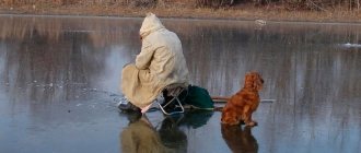
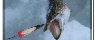
The edge of the ravine attracts the ice fisherman, although the danger that the ice will be clearly fragile near open water is always present. The conditions for safe movement on ice are knowledge of the risks and proper equipment. The information provided here will certainly help ensure your safety.
In autumn, small lakes are the first to become covered with ice, followed by coastal waters and shallow bays of lakes. Freezing of reservoirs occurs from the banks to the reaches. The deepest places may remain unfrozen for another month or two after coastal areas have already become covered with ice, since large bodies of water cool more slowly.
At sea, the covering of archipelagos and open sea areas by ice depends both on the duration of frosty periods and on wind and currents. In the open sea, the ice cover “lives” throughout the winter. Due to the movement and cracking of ice fields, corridors practically devoid of ice may appear between the ice floes, into which the lure angler risks falling.
Factors affecting ice strength
At first, ice forms unevenly, but as the water cools further, it increases in calm weather at a rate of 2.5 mm per day per degree of frost. If, for example, the air temperature is -4 degrees, then we can say that ice a centimeter thick can form within a day.
For clarity, we present a table of ice growth, depending on the ambient temperature.
| Ice thickness | Ice thickness | Ice thickness | |
| Air temperature | < 10 cm | 10-20 cm | 20-40 cm |
| Growth per day, cm | Growth per day, cm | Growth per day, cm | |
| -5 | 4 | 1,5 | 0,5 |
| -10 | 6 | 3 | 1,5 |
| -15 | 8 | 4 | 2 |
| -20 | 9 | 6 | 3 |
Expert opinion
Alexander Petrovich
participant of the Russian Championship in fishing with a float rod
It is worth considering that cloudy or brackish water freezes worse than clean and fresh water, and, accordingly, the increase in ice thickness occurs more slowly.
Other factors also have a big influence:
- depth of the reservoir;
- current strength;
- snow cover thickness;
- wind force, etc.
The thickness of the ice cover usually increases with such a direct dependence on small shallow lakes. In large lakes, not to mention the sea, a large mass of water in deep areas slows down freezing and the rate of increase in ice thickness cannot be determined from the shore.
Snow falling on transparent ice, one to two centimeters thick, is another danger for the lure angler. Even a small layer of snow slows down the growth of ice or even stops it completely.
If snow drifts onto the first ice properly, then a powerful snow cover presses the ice to the surface of the water. Water flows out through cracks onto the surface of the ice. Moving on ice becomes difficult and very dangerous, since the ice can break or even melt in the water under the snow.
Water that flows onto the ice is absorbed into the snow, forming slush. In these slushy areas, ice forms after they freeze. The bearing capacity of porous and brittle ice in areas of aufeis is half that of normal ice.
The temperature difference between the upper and lower surfaces of the ice, especially during a sharp cold snap, causes an uneven increase in the ice cover and the formation of polynyas. The water rises through the ice holes and freezes. With warming, water frozen in polynyas prevents ice floes from expanding to their original size. Internal stresses arise in the ice cover, which push the ice onto the shore, resulting in the creation of ice piles and hummocks.
Recommended reading: Everything for winter fishing
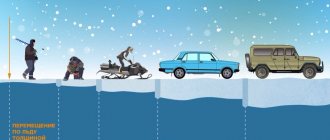
Five-centimeter ice is already holding! Ice strength should be measured on a flat ice field. There must be at least 5 cm under a person walking alone, and for riding a snowmobile, the thickness of the ice on level ground must be 15 cm. When driving on ice, it is safe to move only on marked ice trails.
Expert opinion
Alexander Petrovich
participant of the Russian Championship in fishing with a float rod
Ice formed in windy weather is more fragile than ice formed in calm weather. Sea ice breaks more easily than ice on fresh water bodies.
Cracks reduce the load-bearing capacity of ice, even if they are not through. At the edge of a crack, the strength of the ice is only 40 percent of that of solid ice. The strength of the ice shell at the intersection of cracks is even less, and is only a quarter of the original.
The strength of ice can vary significantly over a short distance depending on the depth, bottom topography and currents. Therefore, a hiker should check the thickness of the ice from time to time.
Traveling on ice using transport
When driving on ice on a snowmobile or some other means of transportation, the load-bearing capacity of the ice, in addition to its thickness, is affected by the movement of water waves under the ice arising from the vehicle. Ice strength is minimal when the speed of the vehicle is higher than the speed of the advancing wave.
When approaching the shore, the speed should be less than 20 km/h, and the shoreline should be literally crawled both when returning and when going onto the ice. You should beware of ice that may simply hang on the coastal rocks. The speed must also be reduced when approaching another snowmobile.
When driving behind each other, the snowmobile behind is exposed to greater danger due to the wave movements of water and ice.
How to determine the thickness of ice by external signs
Before you start estimating the approximate thickness of the ice, first of all, analyze the weather in recent days. Correlate these readings also with the date. It is clear that at the stage of the onset of freeze-up, as well as during the thaw and early spring, the structure of the ice crust will be unreliable.
The blue ice cover is durable. White has half the strength. The gray and yellowish tint and porous structure indicate that the collapse occurs suddenly - even without a preliminary crack.
Then carefully inspect the body of water while standing on the shore. A durable and thick cover is characterized by smoothness and uniformity. Drifts and debris are a serious reason to doubt the quality of the ice cover.
The quality of ice is affected by the speed of water flow and wind. The stronger they are, the worse and more unevenly the water freezes. In addition, the rate of crystallization is much higher in fresh water than in salty sea water. Soft water hardens faster than hard water.
If in the place of proposed fishing or crossing of a reservoir there are freshly discovered trails, then, theoretically, the risks are less. However, when going down to the water, take a closer look: the presence of snowdrifts in the coastal zone may indicate instability of the ice crust - it is stronger in open spaces.
Possible dangers
Spring ice is dangerous! In spring, as temperatures rise, vertical cavities form in the ice. There are no reliable values for the bearing capacity of ice with a damaged structure. Such ice, even with a thickness of 30 cm, can fail a fisherman – an underglacier.
Under the snow, which has packed into the cracks and formed a heat-insulating snowdrift, the ice in the spring is so weak that sometimes it simply melts completely. Therefore, in spring it is better to avoid snowdrifts.
Expert opinion
Alexander Petrovich
participant of the Russian Championship in fishing with a float rod
Dangerous situations often arise on warm spring days, when lure fishermen go to fishing spots at dusk on ice that is strong from the night frost. By the afternoon, the ice can weaken so much that it is often difficult for an angler to even imagine.
It is for this reason that every year a huge number of winter fishing enthusiasts fall through the ice!
Recommended reading: Groundbait
Rivers and straits, as well as the mouths of rivers and streams, are also dangerous places. In the straits, the current intensifies, and if somewhere in a narrow place the bottom is also higher, then the current becomes very significant. Currents in lakes often eat away the ice at the ends of capes.
In the sea, currents support the movement of rising or receding water. In shallow and narrow areas, the ice can thin significantly over just a few meters.
Ice is also fragile at the locations of various sewer outlets. Bridges, piers and large rocks become especially hot in the spring sun and can cause currents that weaken the ice near them.
Dangerous places at the beginning of the season can be poorly frozen deep areas of reservoirs. In spring, danger again lurks near the shore, where reeds, water flowing from land, and large stones increase the fragility of the ice.
Spring waters running on top of the ice corrode old fishing holes so much that even a person can fall into them. Also, most often on small forest lakes, I came across underwater springs, which are especially active in March-April. Here and there tracks on the ice tell of a moose that fell through the ice above such a spring and fought for a long time before getting out onto the ice.
The skis hold up well on thin ice, but if you fall through, there is a real danger to your life. Finnish sleds also cope well with danger, so on unreliable ice it is better to walk and push the sled. Too brisk a step is more likely to lead to a treacherous place.
Sami sleighs (without runners) will protect the traveler if you put a load in them. If you fail, the ice auger and heavy backpack will not interfere with getting out of the water and the risk of destroying your equipment is reduced.
Thermal regime of rivers. Ice phenomena on rivers and lakes
Since the water temperature in the river, as follows from the analysis of the heat balance equation of the river section, responds to meteorological factors (changes in radiation balance, air temperature), the main reason for temporary changes
water temperature in the river – meteorological.
In temperate climates, seasonal changes
water temperatures in rivers. In winter, under the ice cover, the water at the surface of the river has a temperature of about 0 0C. In spring, when air temperature rises, and in autumn, when air temperature decreases, changes in water temperature follow with some lag behind changes in air temperature. The maximum water temperature is less than the maximum air temperature and occurs slightly later than the maximum air temperature. Due to the fact that the water temperature in rivers, as a rule, cannot acquire negative values (supercooling of river waters to negative temperatures without freezing sometimes occurs in the absence of crystallization nuclei), the average annual water temperature in rivers is noticeably higher than the average annual temperature air.
In addition to seasonal fluctuations, the water temperature in rivers also experiences daily changes.
, which also lag behind changes in air temperature. The minimum water temperature is usually observed in the morning, the maximum at 15-17 hours (the maximum air temperature usually occurs 1-2 hours earlier). On large rivers the daily variation in water temperature is usually more than 1 - 2 0C; on small rivers it can be higher. Daily fluctuations in water temperature are well expressed on rivers originating from glaciers.
River water temperature also has spatial variations
. It is well known that the change in water temperature along large rivers flowing in the meridional direction is subject to latitudinal zonality. In such rivers, the greatest difference in water temperature along the river is observed during the heating period. Large rivers flowing from south to north are characterized by large contrasts between water and air temperatures: in the summer, river water heated in the southern latitudes ends up in a colder climate in the northern latitudes. Often the water temperature in rivers changes below the confluence of large tributaries. In the summer, the water temperature in the rivers below the reservoirs decreases significantly, which is explained by the influx of deep water into the tailwaters of the hydraulic systems from reservoirs that have a low temperature. Often, the water temperature in rivers increases noticeably in places where waste water is discharged by industrial enterprises and thermal power plants. In such cases, they talk about “thermal pollution” of river waters.
Along the width and depth of the river, the water temperature changes little due to turbulent mixing. On fast-flowing rivers, differences in temperature in different sections of the flow cross-section usually do not exceed 0.1 0C, on slow-flowing rivers - 1 - 2 0C. However, sometimes you can notice differences in water temperature on the surface and at the bottom, on the core and off the coast. In summer, the temperature at the bottom is slightly lower than on the surface, and near the banks it is higher than in the middle of the river. In autumn, the water temperature near the coast is slightly lower than in the rest of the cross-section of the stream.
Along with flowing waters, rivers also carry heat. The amount of heat transferred by river waters over any period of time is called heat runoff
. It can be calculated using the formula:
where WT is the heat sink, J, over the time interval is the specific heat capacity of water; ρ – its density; T – average water temperature; W – water flow (m3) for the same time interval
All rivers, according to the nature of the ice regime, are divided into three large groups: freezing, with unstable ice cover, and non-freezing. There are three characteristic periods on freezing rivers: 1) freezing; 2) freezing; 3) autopsy.
Freezing of rivers.
The transition of the average daily air temperature in autumn through 0°C serves as a kind of “signal” of approaching ice phenomena. After some time, the water temperature drops to 0°C, and ice phenomena begin.
The initial phase of autumn ice phenomena is lard, i.e. floating pieces of ice film consisting of ice crystals in the form of thin needles. Salo usually floats down the river for 3-8 days. Almost simultaneously, near the coast, where current speeds are lower, banks form - narrow strips of motionless thin ice. As the entire thickness of the water cools, inland ice begins to form in it - an opaque spongy ice mass consisting of chaotically fused ice crystals. Intracoastal ice that forms on uneven river bottoms is called bottom ice. Accumulations of inland ice in the form of lumps on the surface or in the thickness of the flow form slush. The movement of sludge on the surface or in the thickness of the river is called sludge movement. The sludge on the river surface is sometimes supplemented by broken ice coming off the banks and snow - accumulations of snow that has just fallen onto the water.
As the water cools, ice begins to form directly on the water surface of the river far from the banks. The process of ice formation involves accumulations of fat, slush and snow slush. The autumn ice drift begins. On large rivers it lasts 10-12 days, on small rivers - up to 7 days.
During the autumn ice drift, the river bed may be clogged with slush and broken ice. The blockage of the riverbed by this ice mass is called a jam. The formation of a jam is accompanied by a rise in the water level in the upstream section of the river. Sometimes the autumn ice drift is accompanied by a jam, i.e. blockage of the riverbed by floating ice floes.
Freezing over.
As the number of floating ice floes and their size increase, the speed of movement of the ice fields decreases, and first in places where the channel narrows, near islands, in small branches, and then in other sections of the channel, the ice fields stop and freeze together. Congestion can also contribute to this. A continuous ice cover is formed - freeze-up.
Some sections of the river may not freeze for a long time, sometimes throughout the entire winter. Such areas are called polynyas; they often occur in places with high flow velocities, for example, on rapids and rapids, in the tailwaters of hydraulic structures, in places where relatively warm groundwater enters the river and where industrial and municipal wastewater enters. Thus, the origin of the polynya can be both dynamic and thermal.
The thickness of the ice cover on rivers gradually increases during the winter.
One of the simplest ways to assess ice growth on rivers is to establish an empirical relationship between ice thickness and the sum of negative air temperatures. This connection is reflected, for example, in the formulas of F. I. Bydin:
; ,
where is the ice thickness in cm. The first of these formulas uses the average daily air temperature, and the second uses the average monthly air temperature. It is necessary to note the important role of snow cover: the thicker it is, the thinner the thickness of the ice under the snow.
Opening up of rivers.
With the onset of spring, the ice cover on the rivers begins to collapse. This process is influenced by solar radiation, heat input from the air and with warm waters, and the mechanical impact of flowing melt water.
First, the snow begins to melt on the ice. Melted snow water weakens the ice. Along the banks of the river, under the influence of the beginning of heating of the soil and the runoff of melt water from the slopes, as well as rising levels in the river, coastal strips of clean water are formed - edges.
The continuing rise in the water level in the river due to the entry of melt water into the channel causes the ice to move. At first, these are only small (several meters) displacements of the ice fields - movements, and then the weakened ice cover breaks up into individual ice floes and the spring ice drift begins.
Jams during the spring ice break-up often lead to significant increases in water levels and even flooding.
Equipment for moving on ice
The most reliable equipment for moving on ice is a floating rescue suit. Due to its buoyancy, a sufficiently large rescue suit can keep a person on the surface, but at the same time it allows water to pass through.
You can increase buoyancy by packing your items in sealed plastic bags before putting them in your backpack. Remember that the backpack must be tied to your belt, otherwise it may rise above your head in the water.
A stick with a metal tip is a good tool for checking the thickness of the ice. Sticks - “life savers” are needed in order to get out of the hole. The sound of a whistle can be heard further than shouts. To help a friend, a 15-20 meter rope will be useful, and in case of hypothermia, a hypothermic bag will help or even save a life.
Freeze-up
Freeze-up is the presence of a stationary ice cover on the surface of a river (lake).
At all stages of ice formation, from initial stages to freeze-up inclusive, the influence of air temperature is clearly manifested. As we move from the initial forms of ice formation to freeze-up, the role of climatic factors weakens somewhat and the importance of other factors increases - river water content, channel morphology, flow speeds, etc. The greatest influence of non-climatic factors affects the formation of freeze-up. In the pre-freeze-up period, the water mass is cooled so much that the formation of freeze-up is prevented only by increased flow rates and heat brought by ground and lake waters and waters discharged by industrial enterprises. On rivers where the influence of these factors is weakened, freeze-up occurs earlier under the same climatic conditions. Small rivers, as a rule, freeze before large ones, and the ice cover on them is formed by accretion of banks, so it is usually equal and relatively smooth. On large rivers, the formation of freeze-up is associated with the occurrence of ice jams, causing backwater and a decrease in flow speeds. In areas of congestion, ice hummocking occurs, the ice cover becomes uneven, with a chaotic accumulation of ice floes.
Since congestion does not occur everywhere and not at the same time, freeze-up on large rivers in lowland areas does not form simultaneously in different areas: first, freeze-up forms on reaches, then on riffles, and there is a difference in the timing of freeze-up in different sections of the same river. rivers increases with increasing water content and flow speeds.
Research in recent years has shown that the establishment of freeze-up on large rivers over a considerable distance occurs as a result of the sequential movement of the ice edge upstream from the centers of ice bridges. On mountain rivers, freeze-up is a relatively rare phenomenon, especially in the southern regions, such as the Caucasus and Central Asia. Here it is formed in areas where accumulations of large masses of slush are formed.
Most of the rivers in our country are characterized by stable ice cover. Only on the rivers of the Black Sea coast of the Caucasus and on the rivers of the southern coast of Crimea is ice cover not observed at all due to the warm climate. The distribution of the timing of freeze-up on CIS rivers is generally characterized by latitudinal zonality. In the European part, this zonality is somewhat disrupted under the influence of intrusions of warm air masses from the Atlantic. Freeze-up on large rivers of Siberia is delayed by about 10 days compared to small rivers. During the period of freeze-up, areas with an ice-free water surface - polynyas, or lanes - are sometimes preserved on rivers. Polynyas have two origins: dynamic polynyas and thermal ones. Polynyas of the first category occur in areas of concentrated fall - on rapids and rapids. They are common on the rivers of Karelia, in the northern part of the Russian Plain, and on the mountain and semi-mountain rivers of Siberia. These polynyas sometimes persist throughout the winter and are hotbeds for the occurrence of sludge, the accumulations of which under the ice below the polynya form ice jams.
Polynyas of thermal origin arise either under the influence of abundant releases of relatively warm groundwater or the discharge of industrial waters, or, if a river flows out of a lake, due to the inflow of warmer lake waters. Thermal polynyas sometimes reach significant sizes. So, for example, R. The Emtsa, a tributary of the Onega, does not freeze for more than 100 km, despite the harsh winters. Thermal polynyas are common on the rivers of the Yana-Kolyma mountainous country and Chukotka. In most cases, areas with polynyas on these rivers are located in the foothills, which are characterized by thick pebble deposits, replete with groundwater outlets into the river bed.
An example of polynyas at the sources of rivers flowing from lakes are the polynyas at the sources of the Neva, Angara, Volkhov, etc. During the period of freeze-up on some rivers, often in permafrost areas, aufeis form on the surface of the ice cover - ice growths in the form of layers, thickenings , mounds, sometimes bizarre shapes.
In winter, due to an increase in the thickness of the ice cover or blockage of the riverbed by slush, freezing, the living cross-sectional area decreases. In such cases, a pressure is formed under the ice, breaking the ice, and through the cracks the water comes to the surface of the ice.