Story
The idea to build a powerful hydroelectric power station on the Volga River in the Samarskaya Luka area - in order to make up for the shortage of electricity in the Middle Volga region - arose even before the revolution, in the early tenths of the 20th century. However, the design task turned out to be difficult, and research on this issue was carried out until the summer of 1939 - only then was the waterworks project approved. But in the next decade, its construction did not begin - all work on it was suspended - due to the outbreak of World War II and the high cost of constructing some elements of the dam.
After the end of the war, plans to build hydroelectric power stations were returned to. The project was adjusted towards greater efficiency, and a more optimal location for the dam was also chosen. On August 21, 1951, the USSR Government issued a decree “On the construction of the Kuibyshev hydroelectric power station on the Volga River” - it was then that work on the construction of the hydroelectric complex officially began, the bulk of which occurred in 1953-1955. Within 3 years, the dam was built, on October 31, 1955, the river was blocked and the filling of the reservoir began. On December 29 of the same year, the level in the reservoir reached a level sufficient to launch the first hydraulic unit - which was done. By October 1957, the remaining 19 hydraulic units were gradually put into operation, and the hydroelectric power station reached its design capacity. On August 10, 1958, a commission of the USSR Government approved an act on acceptance of the hydroelectric power station for permanent operation.
After the Kuibyshev Reservoir was filled, a considerable area was flooded - more than 5 thousand km². It was necessary to move 290 settlements and resettle 150 thousand people.
“People even went crazy”
Tatarstan took over half of the reservoir's territory. In the early 50s, the Council of Ministers of the USSR established a structure in the TASSR with the vile name “Tatspetsleszag”. It must cut down all the forests in the area of the future reservoir on the territory of Tatarstan so that they do not interfere with navigation. At first, the forest area for felling is 38 thousand hectares, the next year it is changed to 60 hectares, then it is changed again - 120 thousand. A year later there was another change - 170 thousand hectares! Imagine how much forest had to be destroyed. A village has stood near the forest for hundreds of years, and suddenly the forest begins to be destroyed. And the residents look at this and guess that immediately after cutting down they will be evicted. Some even went crazy. There were several such cases. For people it was a real apocalypse.
I was asked whether there was compensation to Tatarstan for these losses? No! The Union Center itself made decisions on construction, down to every comma. Of course, the displaced people were given preferential loans for housing, new houses were built for them, but the quality of these houses was simply terrible.
Hydrology
- Reservoir type: channel.
- River on which it was built: Volga (the dam is located 1472 km from the mouth).
- Other tributaries: Usa, Muranka, Tisherek, Taidakovo, Maza, Beketovsky, Elaurka, Bolshoi Cheremshan, Birlya, Erikla, Sosnovka, Erikla, Melekess, Sengileika, Tushenka, Kalmayur, Arbuga, Attsa, Uren, Maina, Krasnaya, Utka, Mordovskaya, Ishimovskaya, Abyss, Karamalka, Mordovka, Kama, Aktai, Mesha, Bryssa, Shuranka, Kurlyanka, Oshnyak, Betka, Urayka, Shentala, Bolshaya Bakhta, Land, Shumbut, Bersut, Sheshma, Zabornaya, Omarka, Pakshinka, Vyazovka, Uratma, Kazanka , Sviyaga, Sekerka, Sulitsa, Bag, Ilet, Anish, Malaya Kokshaga, Bolshaya Kokshaga.
- Bottom: muddy, sometimes sandy or rocky, there are areas with snags.
Chemical composition
- Water: fresh.
- Salinity: 0.6 g/l.
- Water class according to salt composition: hydrocarbonate-calcium.
Tributaries
(distance from the mouth is indicated)
- 1474 km: unnamed, near the town of Zhigulevsk (pr)
- 1489 km: Usa (pr) Usinsky Bay 45 km: Muranka
- 49 km: Tisherek
- 25 km: Birlya
- 16 km: Main Bay: Krasnaya
- 8.6 km: Aktay (lv)
- Sekerka (BG)
Geography
- Coordinates: 54°42′09″ N. latitude, 48°51′34″ e. d.
- Height above sea level: 53 m.
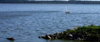
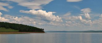
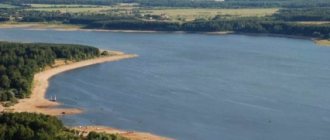
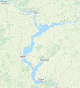
- Coastal landscape: the reservoir is located in the central part of the Middle Volga region - on the border of the forest-steppe province of the Volga Upland and the Lowland Trans-Volga region. The main part of its banks is open space, interspersed here and there with small areas of mixed and deciduous forests. The largest forest area is located on the right bank of the Kama River bay; also quite large overgrown areas are located near and opposite the bay formed by the mouth of the Bolshoy Cheremshan River, and in the vicinity of the dam. Most of the coastline of the reservoir is quite elevated; there are very few swampy areas (they are mainly located at the mouths of some rivers and at the beginning of the bay formed by the Kama).
- Settlements on the banks: the largest are Kamskie Polyany, Chistopol, Alekseevskoye, Laishevo, Novocheboksarsk, Zvenigovo, Zelenodolsk, Vasilyevo, Kazan, Kamskoye Ustye, Bolgar, Tetyushi, Staraya Maina, Isheevka, Cherdakly, Ulyanovsk, Novoulyanovsk, Sengilei, Dimitrovgrad, Yagodnoye , Tolyatti, Zhigulevsk.
Territorial location
- COUNTRY: RF . Region: Republic of Mari El . Districts: Volzhsky, Zvenigovsky.
- Districts: Alekseevsky, Verkhneuslonsky, the city of Kazan, Zelenodolsky, Kamsko-Ustinsky, Laishevsky, Mamadyshsky, Nizhnekamsky, Rybno-Slobodsky, Spassky, Tetyushsky, Chistopolsky.
- Districts: Kozlovsky, Mariinsko-Posadsky, Cheboksary.
- Districts: Stavropolsky, Syzransky, Shigonsky.
- Districts: Ulyanovsk city, Melekessky, Sengileevsky, Staromainsky, Ulyanovsky, Cherdaklinsky.
Interactive map
Geographical information
The reservoir was created in 1955-1957, after the completion of the construction of the Zhigulevskaya hydroelectric power station dam, which blocked the Volga valley in Zhiguli near the city of Stavropol (now Tolyatti). The name is given after the city of Kuibyshev (now Samara), located downstream.
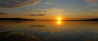
The length of the reservoir is more than 500 km, the greatest width at the mouth of the Kama is 40-44 km, the area of the water surface is 6.45 thousand km² (among rivers - the second largest in the world), the total volume of water is 58 km³, of which 34 km³ is useful. The catchment area is 1210 thousand km². The average depth is 9.3 m, the greatest depth is 41 m (dam of the Volzhskaya Hydroelectric Power Station). The total length of the coastline is 2604 km.
The backwater level at the dam is 29 m, it extends along the Volga to the city of Novocheboksarsk, along the Kama River to the city of Naberezhnye Chelny. The reservoir forms large bays along the valleys of the Kama, Sviyaga, Kazanka and other rivers.
The main purpose of the reservoir is to generate electricity, improve navigation, water supply, and irrigation. In addition, it is used for fishing.
The reservoir greatly changed the flow regime of the Volga both above and below the dam: the flow during high water decreased significantly, and during low water it increased. Fluctuations in water levels now near the city of Kazan are 5-6 m, while before the creation of the reservoir they reached 10-11 m. After its creation, the reservoir began to freeze 3-5 days earlier and later become free of ice. The microclimate in the 3-6 km zone near the reservoir has changed significantly, processes at the bottom and in the coastal strip have been rearranged, abrasion and erosion of the banks have begun, and landslides have intensified. The conditions for the growth of coastal and aquatic vegetation and the habitat of birds and fish have changed greatly.
Ecology
The general environmental situation in the Kuibyshev Reservoir (according to the official version) is considered relatively satisfactory, and the average water pollution throughout the reservoir corresponds to the “moderately dirty” class. However, in areas where large settlements are located (especially those where industry is developed and wastewater is discharged), the water quality is much worse. Here, the maximum permissible concentrations of pollutants (heavy metals, phenols, petroleum products, etc.) are several times exceeded, and even in fish, excesses of these indicators are observed. Also, a deterioration in water quality was noticed in the places where the main tributaries flow into the reservoir - the Kama and Volga, which themselves are quite polluted - due to cities and industrial enterprises located in their basins (the Kama carries the dirtiest water). As for the places where the water contains the least amount of pollutants, this is definitely the water area of the reservoir near the dam.
Shallowing of the Kuibyshev Reservoir in May 2021
In April-May 2021, the water level in the Kuibyshev reservoir dropped to 49.86 m above sea level (according to the rules, the minimum water level in the reservoir at the hydroelectric dam during the flood period should not be lower than 49.0 m). In Tatarstan, the river went 3 km from the shore, in Togliatti the water went 500 meters. A critical situation has developed on Kazanka and Sviyag. According to Rosvodresursov, according to whose instructions the reservoir was decommissioned, this happened due to the low inflow of water into the Volga, as a result of which the annual increased water flow provided for by the rules for watering the Volga-Akhtuba floodplain was carried out at the expense of the water reserves of the Kuibyshev reservoir. The prosecutor's office also pointed to uncontrolled sand mining. On May 12, 2019, the reservoir began to fill; as of June 20, 2019, the reservoir level was at 52.55 m, which is 0.45 m below the normal retaining level[55][56][57][58][ 59].
The Institute of Ecology of the Volga Basin of the Russian Academy of Sciences called the cause of shallowing a possible error in calculations. Because of this, the fish had nowhere to spawn, and other microorganisms that lived in the water and supported the ecosystem (plankton, benthos) died. The institute also named the reasons for the environmental pollution of the Kuibyshev reservoir. The river is mainly polluted by diffuse (uncontrolled) runoff. These are all kinds of washouts from fields, after rain of chemicals and fertilizers, motorists who wash their cars in the river, small landfills along the shore near villages and dachas, garbage and toxic substances from which end up in the water. Cesspool toilets whose contents seep into groundwater. The main reason for the bloom of the reservoir is said to be the proliferation of blue-green algae in it due to the discharge into the Volga of incompletely purified wastewater, mainly from the production of soap powders with phosphorus.[60]
Interesting Facts
Storm winds of the Kuibyshev reservoir
The construction of such a grandiose reservoir could not but affect the local climate. It has already been noted that in the spring it becomes warmer here later, and a temperature difference of 10 °C can be observed; winter is also slightly delayed - with a difference of 2-3 °C. But the main “innovation” in the weather is an increase in wind speed and the appearance of periodic storms - which is quite common for such large-scale water areas.
As fishermen say, wind on the Kuibyshev Reservoir is the rule rather than the exception. Statistics show that its average speed varies from 2 m/s to 5 m/s. It should also be taken into account that in the water area itself the wind is always one and a half times stronger.
In gusty winds, its speed can briefly reach 28 m/s. Approximately once every two years, a storm of 9 points is observed here; once every five years, weather forecasters note a storm of 10 points (the windiest period is mid-autumn). At the same time, the height of the waves - depending on the direction of the wind - can reach from one and a half to two and a half meters.
IMPORTANT: all of the above should be taken into account when visiting a reservoir, especially when using watercraft.
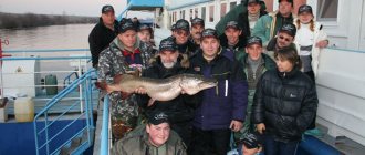
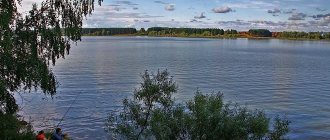
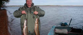
Fishing on the Kuibyshev Reservoir
- Types of fish: ruff
- perch
- bersh
- zander
- round goby
- bighead goby
- sand goby
- goby
- star-shaped button
- rotan
- common sculpin
- mustachioed loach
- common spined loach
- Siberian spined loach
- loach
- Demoiselle minnow
- lake minnow
- common gudgeon
- whitefin gudgeon
- Verkhovka
- bitterling
- bleak
- roach
- rudd
- dace
- chub
- ide
- asp
- saberfish
- Podust Volzhsky
- bream
- silver bream
- blue
- white-eye
- golden crucian carp
- silver crucian carp
- tench
- carp
- White amur
- silver carp
- bighead carp
- buffalo smallmouth
- buffalo largemouth
- buffalo black
- European catfish
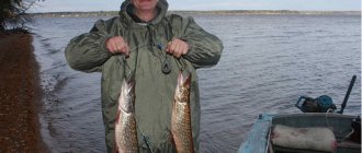
- pike
- European smelt
- whitefish
- peled
- European vendace
- brook trout
- rainbow trout
- lake trout
- burbot
- three-spined stickleback
- nine-spined stickleback
- plump-cheeked pipefish
- river eel
- Russian sturgeon
- beluga
- sterlet
Fishing spots
Among the fishing spots on the Kuibyshev Reservoir, one should first of all highlight areas where the main flooded channel passes (the Kama to the confluence with the Volga and then the Volga) and other significant tributaries. This is where the largest fish are usually caught. Also quite interesting are the bays at the mouths of rivers, especially large tributaries, where there is a wide variety of terrain - from underwater holes to numerous islands - which provides very pronounced differences in depth. As for specific places, we can recommend part of the water area of the lower reach - from the dam and up to Ulyanovsk - many fishermen speak well of these areas. However, given the huge size of the reservoir, all this will be available only if you have a watercraft with a motor (and it is also advisable to have a GPS navigator with you with the ability to take notes). As knowledgeable fishermen say, there is nothing to do here on a rowing boat. IMPORTANT: when using a watercraft, do not forget about the winds, which can be quite strong on the reservoir (which has already been described in detail above - in the chapter “Interesting Facts”).
Fishing Features
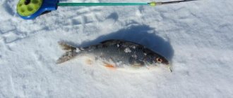
Like many reservoirs of the Volga-Kama cascade, Kuibyshevskoye is especially interesting in terms of catching predatory fish: both for spinners in the summer, and for spinners and girdles in winter. At the same time, the most popular object of fishing is pike perch. It is quite numerous and is usually represented by medium-sized and medium-sized individuals. There are also trophy pike perch. It has been noticed that this fish is best caught on a flooded riverbed, while the most active bite is observed in late autumn and on the first ice.
The second most popular predatory fish is perch. Depending on the location, it can be represented by small sailors, or specimens weighing up to 300 grams, and in some places quite good, half-kilogram individuals. It has been noticed that the largest perch concentrate in deep places.
The third most common species in catches is bersh. Often caught when fishing for pike perch.
All three species of perch are mainly caught using silicone baits, of which twisters of yellow and green colors have shown better results. Thin spinner baits also work well for pike perch. But this is in the summer, and in the winter - as usual - balancers and bottom spoons.
The fourth predator that is regularly caught is pike. Usually it is not particularly large in size; trophy specimens are rare.
As by-catch for the above-mentioned species, sometimes ide and asp are caught on a spinning rod, and sometimes catfish are caught when placing the bait at the very bottom.
In terms of white fish, the reservoir is definitely interesting for bream, including large ones. The most productive way is to “ring”, from a boat on the riverbed. Other bottom gear also works well - the traditional one with a bell and a feeder, but they are usually used from the shore. In addition to bream, carp and catfish are also occasionally caught.
Quite successful fishing is also possible from the shore using float gear, but this is mainly used for fishing for smaller fish - roach, bream, silver bream, rudd. By the way, if there are large fish in the reservoir and regularly caught, such an activity may seem of little interest to someone.
How to get there (get there)
The following is a list of entrances (approaches) to the reservoir - 3 options.
Kama Bay (from Kazan)
- Coordinates: 55°14′00″ N. latitude, 49°48′58″ e. d.
- Distance from Kazan: 118 km.
- Delivery option: any car.
- How to get there: from Kazan you should go in the direction of Chistopol. After the long bridge over the Kuibyshev Reservoir there will be an interchange (not far from the village of Alekseevskoye), at which you should turn right - towards Samara, and then follow this direction - until the sign for Lebedino, where you need to turn. You should drive through this settlement - the road will come out to the shore of the reservoir.
Kama Bay (from Izhevsk)
- Coordinates: 55°14′00″ N. latitude, 49°48′58″ e. d.
- Distance from Izhevsk: 385 km.
- Delivery option: any car.
- How to get there: from Izhevsk you should go in the direction of Naberezhnye Chelny, before which (to the dam of the Nizhnekamsk reservoir) turn right - towards Kazan. At the junction near the village of Bolshoi Mashlyak, turn right - to Rybnaya Sloboda, then move to this settlement, after passing which - continue driving to Malaya Elga, where at the intersection turn left, then move in a forward direction, without turning anywhere - through the Kuibyshev Reservoir across the bridge. Next - as in the previous version.
Kama Bay (from Ufa)
- Coordinates: 55°14′00″ N. latitude, 49°48′58″ e. d.
- Distance from Ufa: 486 km.
- Delivery option: any car.
- How to get there: from Ufa you should go towards Kazan (Zatonskoye Highway). After Chistopol, at the junction near the village of Alekseevskoye, you should turn towards Samara (left), then as in the first option.